Letters, Points of Interest, Week in Review (Announcements, Contracts, Products, Events, Education and Training, Hires) Back Issues, Advertise, Contact, Subscribe/Unsubscribe If, for some reason you cannot read this document, visit: http://www.gismonitor.com/news/newsletter/archive/091103.php
EDITOR'S NOTE The geospatial industry has changed, too. We've all looked again at our technology, data and expertise and tried to tease out new and better ways to prevent incidents, prepare our infrastructure and respond, should that be necessary. That contribution is the best legacy we can leave in remembering those who lost their lives two years ago.

THE PUBLIC SECTOR, THE PRIVATE SECTOR AND THE EDUCATED CONSUMER
Consider that this week the GeoCommunity put out a press release announcing that it "now has worldwide coverage of Orthorectified Landsat Thematic Mapper Mosaics available via the GIS Data Depot pemium [sic] download mechanism and via CD distributon [sic]. The mosaics are in MrSid format and in a UTM projection. The imagery was obained [sic] in 1990." NASA and USGS manage Landsat, which makes it federal data, so I wondered if the same files were available via GeoData.gov. GeoData.gov has 488 references to Landsat data and applications, some from commercial providers and some from the government. The website has four references to "Landsat mosaic" from two commercial companies. One makes the data available for non-commercial use for free, the other points users to the Geography Network for viewing access and offers the data for $2,500.
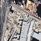
A Google search for "Landsat mosaic 1990" pointed me to a NASA website where I could view and download scenes at no cost. There's also a terrific tutorial [the image at left is from that document] and a notation that Earth Science Corporation collected and processed the data for NASA. This website offers downloads in PNG or MrSid. There's a discussion of data CDs but I found no information on how to purchase them. It's my sense that Google is still the best tool for finding geospatial data for the U.S. on the Internet. That's in part because Geodata.gov is still new, launched just this past June. My experience does raise an interesting challenge for GeoData.gov's curators. Commercial providers will register their offerings at GeoData.gov in the hope of selling data (and perhaps services). On the other hand, how can we be sure websites like the NASA site above are registered at GeoData.gov? Perhaps we need to have a team of interns combing Geodata.gov (and perhaps Geography Network and GeoCommunity and other websites) to tease out the government data download options, and register them on the portal? In the mean time, we all need to be "educated consumers."

ORACLE 10G AND GEOSPATIAL Both versions (Locator and Spatial) get performance boosts: Oracle Locator 10g has up to 1000% performance improvement for location (distance) queries over Oracle9i, according to Oracle. R-tree indexes and spatial aggregating also speed things up. Locator gets support for parallel spatial queries while Oracle Spatial adds a network data model (network analysis and routing), a topology data model (useful for maintaining data integrity during editing and also speeds queries), geocoding (Java-based), native support for raster imagery, and new spatial analysis tools specifically applicable to business intelligence applications. Oracle Application Server 10g comes with MapViewer, a development tool that can be used to build and display maps in either a browser or in a specific application. A discussion of the Oracle 9iAS map viewer by several Oracle folks at Map Asia 2002 is here. I didn't find any information on the enhancements in the new 10g release of MapViewer. Oracle touts several benefits of the new release's spatial offerings: low cost of ownership, low risk, high value and increased usability. Products are expected to ship by year-end according to one report, by early next year according to another and this month by a third. How does this announcement affect the geospatial marketplace? These additions have been in the works for some time. No one should be surprised to hear that more traditional GIS functionality has migrated into the database. Oracle has been talking about topology support for some time. Imagery support in Oracle has also been on the horizon. But, with the addition of network tools, geocoding and other goodies, it sounds like Oracle has many of the basics inside the database that make up what geospatial professionals consider a GIS. Of course, all those new features are really just a set of tools that need to be collected together and accessed by a front-end application (perhaps built with the MapViewer noted above, or a custom app, or something created with open source). Still, the core technology is in there. And, the technology inside the database, says David Sonnen of IDC, means two things. First it means that geospatial technology is truly becoming ubiquitous since Oracle dominates the overall enterprise market. Second, he notes, in an IDC event flash written with Henry Morris, this announcement may "disrupt" existing GIS vendors. "Disruptive" here is actually a positive term, referring to the opening of new markets. The ubiquity point is well taken, in particular because Oracle, in introducing these new tools, can bring geospatial more quickly and easily into potential users' hands than the traditional GIS players ever could. Remember that in order to get in the door with a potential buyer, Oracle plays the database card first and the geospatial card much further down on the list. The geospatial players' only card is geospatial and that can be a tough sell outside of traditional GIS-friendly markets. As for the disruptive element, that's going to be the most interesting to watch. Will GIS vendors see Oracle's writing on the wall and move closer to the other database vendors like IBM and Microsoft (from which Oracle is, at least in part, trying to distinguish itself with these enhanced spatial capabilities)? Will geospatial vendors find new ways to stay on good terms with Oracle and still make money? Will existing GIS users in time change their technology mix to take advantage of these offerings and use their traditional GIS vendor in a new role in the enterprise? Will Oracle roll out the solution with enough support to make 10g a viable geospatial platform? Will traditional business users explore how geospatial technology can help them, simply because some of it comes "in the box?" Which GIS vendor will benefit the most as 10g and its geospatial tools come to market? I'd guess Intergraph, the only major GIS player that didn't move down the middleware path to enterprise database computing. While ESRI, Autodesk and MapInfo were acquiring, tweaking and marketing SDE (now ArcSDE), Vision* (now GIS Design Server) and SpatialWare (still SpatialWare) respectively, Intergraph laid out a plan to connect its GIS (GeoMedia) directly to Oracle and Oracle Spatial, and has not wavered from that stance. I don't mean to suggest the other vendors will drop longtime relationships with Oracle. That'd be cutting off the leg to spite the foot since Oracle owns some forty-odd percent of the enterprise marketplace. Each vendor would like a part of that pie. Therefore it's time traditional vendors take a step back and think hard about how to leverage the technology Oracle has announced.

AUTODESK PUTS PDF IN ITS PLACE DWF, originally Drawing Web Format, was introduced with either AutoCAD 13 or 14. Autodesk tells me the AutoCAD Internet Publishing Kit was a Release 14 add-on. I recall it was introduced in 1996 as an add-on for AutoCAD R13c4. The Kit's contents were later integrated into R14 in 1997. Last year, during the announcement of AutoCAD 2004, version 6 of the format was renamed Design Web Format in part to highlight that designs are 3D. DWF is not at this time 3D compatible, but it sounds like it will be soon. At a non-disclosure briefing on the new AutoCAD I learned that DWF had a new champion in Tony Peach, Director of DWF Corporate Strategy. Peach's presence indicated to me that after seven years Autodesk was getting serious about DWF. The format, from my standpoint, had never seemed to gather much steam in the CAD marketplace. The new campaign attempts to revitalize DWF and illustrate its true place in sharing engineering and design data. In a meeting this week Peach referred to it as "the foundation format for collaboration" and highlighted that all Autodesk products would soon write it (most do already though some require a download, like Revit) and that new viewers are likely down the road. It's worth noting, too, that the campaign follows the release of Acrobat Professional 6,that among other things, provided new functionality for CAD file support. I wrote about it a few months ago. So, what's the big deal about DWF? It was specifically created for design data, unlike PDF, which was designed for "office" documents. DWF files are smaller than PDFs. They are created more quickly, read more quickly in DWF viewers, and rendered faster. And, noted Peach, DWF supports higher resolutions that are key in GIS and other work. Peach went so far as to say that Autodesk's printer manufacturer partners were not threatened by DWF since their clients would be confident to receive all the needed parts of a file (fonts, hatches, etc.) that sometimes don't travel with a DWG. Today, DWF writing comes free in Autodesk's creation software (AutoCAD, AutoCAD LT, Autodesk Map, Envision, etc.). To read DWF you need the free Express Viewer that is currently supported under Windows, but will soon be ported to Mac OS X, along with the developer toolkit. I asked about support for UNIX and Peach noted that UNIX was "close" to Mac OS X and it was possible. With creation coming "free" with Autodesk products and a free viewer, what is Autodesk return on investment in this campaign? That was the question I had in my head from the beginning and was pleased that Peach addressed it before I asked. He explained that a big part of the campaign addresses customer needs. He noted that customers find that PDF doesn't have enough features for their work. Furthermore, Autodesk is leading the way to a standard for sharing design information. Right now, there isn't one. DWF is an open, published format, that has a suite of developer tools, all free, a free Windows system printer driver, DWFwriter, and a free viewer, Express Viewer. Finally, the more advanced viewing and reviewing tools for DWF will likely not be free. Volo View, which supports both DWF and DWG formats, among others, and offers redlining, for example, is not free. As for DWF's role in geospatial, Peach noted several times that MapGuide would be able to access DWF files as source for Web mapping in the future. He also noted that there is space for attribute information in DWF, and that products like Map might soon write out that data into the format. I asked Peach how extensively PDF is used within Autodesk's other groups since my sense was that PDF was used in mapping, but mostly to distribute maps to the public on public websites, not so much for engineering review. (Readers, is that your experience?) Peach noted that Autodesk users in building design, manufacturing, asset management/facilities management were heavy users of PDF. He also noted that at the upcoming Highway Engineers Exchange Program (HEEP) conference there would be a session on using PDF effectively. All are good candidates for DWF use. I did a quick check for mapping using DWF and PDF. I started with Pima County Arizona, a website I visited in 1997 when I did an article for Cadence on the World Wide Web and the AutoCAD User. Back then the county was one of the early users of DWF. Maps are still available in DWF, but the website touts that most are available via MapGuide, too. Indiana University offers maps in DWF and calls the format a "CAD-type format." Sparwood, British Columbia, Canada offers both DWFs and PDFs. Flipping through my old article I noted several other CAD Web formats that I've not heard much about in the last few years: SVG (scalable vector graphics, which is a W3C standard) CGM (Computer Graphics Metafile, used by Intergraph and Bentley, which now has an OASIS community, CGM Open) and SVF (Simple Vector Format) from SoftSource, a CAD company on the West Coast. I think for now, DWF is not a big deal for geospatial users. However, with tools specifically geared to geospatial needs, it will be worth a serious look.

Brent A. Jones, Vice President of Energy & Telecommunications at James W. Sewall Company noted: "I don't know what mapping company has been producing maps the longest, but we have maps made by the Sewall's that predate our 1880 established date." Bill Huber responded to my first guess, Sanborn, founded in 1866. "Surely we can do better than that, especially if we are creative. The question does not concern companies specifically devoted to map-making or even to publishing, so that gives us a broad scope. For instance, the railroads have been around since about the 1830's and have published maps since before 1866: see [this website] for evidence of a Union Pacific map published in 1865. I bet a deeper investigation would produce railroad maps from the 1840's. "Another thread worth pursuing is acquisitions: companies that published maps in the 18th and early 19th centuries in the U.S., through a long train of acquisitions and mergers, may technically still be operating under other names today. For instance, [t]here's a map published in 1850 by a small railroad company that likely exists as a small part of a modern company. On this basis I wouldn't be surprised to find an operating U.S. company that can claim to have published maps in the early 1700's. "Another thought is newspapers: they must have occasionally published maps. Just find a modern newspaper that has been in business a long time: The New York Times was founded in 1851, for example. "The Web sites referenced here can be accessed through [the Library of Congress]." � Steven Ramage of Laser-Scan noted that Turnitin is a good resource on plagiarism, especially in schools. � Several readers including Dennis Nazarenko, Tige Procyshyn corrected a Canadian geography error on my part. My apologies. "The City of Brandon is in the Province of Manitoba, not Alberta." � The Point of Interest regarding Will County, Illinois paying a consultant to explore how it should charge for its GIS data prompted me to ask, "What does this say for NSDI and related matters?" Bruce Westcott provided this thoughtful reply: "It says that: The editor notes: Westcott's e-mail was the first I've received with a digital signature. Jim Bash put the question in a historic perspective. "I was trying to remember how many years it has been since all the

POINTS OF INTEREST No Need to Wait for GIS Day. At the 86th Clay County Fair in Iowa visitors can see an authentic log cabin turned into an environmental education center, play with a GIS, and print out maps.
A New Twist on Find the Nearest. Overture, a pay-per-click search engine, currently being acquired by Yahoo, has a new spatial tool up its sleeve. Businesses that pay to be listed will now be shown when a visitor queries for all the providers of a particular product in the local area. The service is currently in beta. My test using "kite" and "Boston, MA" turned up a message saying no listings were found, but a symbol on the map indicated one hit. It seems to me a price comparison might be incorporated, too. A New Map for Japan. The Land, Infrastructure and Transport Ministry in Japan is planning a digital three-dimensional map of the country for use in a variety of areas including disaster preparedness and businesses development. Ministry sources estimate the cost of the project, which would improve map accuracy, at 7.8 billion yen over three years. The project is expected to start in the next fiscal year. Finding Wireless Interference. AirMagnet, a company that provides management and security of wireless networks at large conference such as Comdex and MacWorld has a new tool in its arsenal. It can track down those on the floor interfering with the wireless local area network. Says a Vice President at showNets, a company that uses the technology, "Our AirMagnet showed us that one user at MacWorld was broadcasting DHCP addresses from his laptop and disrupting wireless connectivity for an entire segment of the exhibit floor. AirMagnet has a 'locator' capability that works like a GPS device. With AirMagnet we were able to track this user down and fix the problem in minutes, even though the user was moving around the show floor." Finding Wireless Freeloaders. Hitachi will bring a WLAN-based positioning system to market in Japan. It is expected next month and will serve two types of markets. The first are traditional locational challenges, like asset management and small area navigation offerings in areas such as theme parks. The second includes finding users of a wireless network, particularly freeloaders, who are outside of a building. Wouldn't it be easier/cheaper to secure the network? The system is expected to cost about $25,000. Odd Geography. A few weeks ago I received a letter from the University of Phoenix, Greater Boston Campus, suggesting I consider an IT degree from that institution. The University actually has three Boston locations. Incentives. To encourage participation in GITA's 2003-2004 Geospatial Technology Report, Bentley is providing the enhanced incentive of a drawing for five free copies of the final report. Participants receive a 50% discount on the full price from GITA, along with a chance of winning other goodies from GITA for participating by September 15th, even if they don't win Bentley's drawing. Quote of the Week. "It's warmer but drizzling [in Wellington, New Zealand]. I get lost trying to return to Copthorne Hotel Plimmer Towers, a hotel with no visible entrance. A passer-by offers to help, but I demur, determined to find my place on the map, a map I later realize is of a different city." Ralph Grabowski, CAD guru, on finding his way on a trip down under.

� Announcements Navigation Technologies and Mobility Technologies, a provider of real-time traffic and transportation information and services, are collaborating on a four-city trial of Navigation Technologies' real-time traffic data solution for North America. The trial is currently underway in Chicago, Los Angeles, New York, and Detroit. The American Congress on Surveying and Mapping's 31st annual map design competition is underway. UK-based Ten Sails, a spatial business builder (Peter Batty's company) announced that it has acquired New Orleans-based TerraPrise, a GIS services company. The acquisition will expand the company to the U.S. Other such acquisitions are planned for the future. TerraPoint LLC unveiled its upgraded Airborne Laser Topographic Mapping System (ALTMS). Details on the five point upgrade are available here. The Department of National Defence's Mapping and Charting Establishment (MCE) was recently presented with an Award of Excellence at ESRI Canada's annual ESRI Regional User Conference in Ottawa. Cambridge-based company Ubisense, provider of real-time indoor tracking systems has announced the start of a strategic partnership with DEGW, the international design consultancy. The pairs' future research will explore the potential of location awareness-based applications in the workplace in a number of European countries. � Contracts and Sales Michael Baker Jr., Inc. has been selected by the Federal Emergency Management Agency (FEMA), which is part of the Department of Homeland Security, as the preferred firm to negotiate a Repsol YPF selected and awarded contracts to Thales GeoSolutions and Sonsub to design and build Remotely Operated Vehicles for the deepwater survey and investigation. Another contract was awarded to Sonsub, in partnership with Thales GeoSolutions, to carry out a deepwater survey, investigation and evaluation study on the wreck of the Prestige oil tanker. Prestige sank in deep water off the coast of Northern Spain in November of 2002, and is still carrying a substantial amount of heavy fuel oil. Snowflake Software of Southampton, England, announced that the Cyngor Cefn Gwlad Cymru, Countryside Council for Wales, has chosen its GO Loader to build and manage its Oracle Spatial database of Ordnance Survey MasterMap data for Wales and surrounds. Z/I Imaging Corporation, an Intergraph Company, announced that Aero-Metric, Inc. (Sheboygan, Wisconsin) has purchased the Z/I Imaging Digital Mapping Camera system. � Products Positive Systems, Inc. recently launched release 3.1 of the Digital Images Made Easy (DIME) software. Currently used in aerial photography and mapping shops worldwide, DIME is the alternative to traditional photogrammetric methods for imagery preparation. The latest version of DIME includes new single seat and network license options. The 3.1 release has also been bundled with a new seamline editor, enhanced user interface and improved reporting. Autodesk Location Services announced Autodesk LocationLogic XML Web Services, a platform that helps developers create new, or location-enable existing, applications on the Autodesk Location Services platform, Autodesk LocationLogic. Tele Atlas released the latest version of its turn-by-turn digital map database - North America 3.2 in MultiNet Shapefile and MultiNet GDF formats. Other formats, such as Oracle Spatial, ESRI SDE Export, Telcontar RMF, and MapInfo TAB will be released shortly. GE Power Systems introduced ZEHPlot for Smallworld application software. This new Smallworld product, offered by GE's Network Reliability Services business, brings Raster Image Processing (RIP) technology to the Smallworld user to allow complex images to be converted into a simple format for printing, without distorting the quality of the image. Remember ArcPress from ESRI and ProPress from MapInfo? Same thing. ARCBridge released ARCBridge FIRESolv Net and ARCBridge FIRESolv Plan, products for fire department support staff for mission-critical GIS projects. ARCBridge FIRESolv Net is an automated ESRI ArcGIS 8.3 network analysis program module that is designed to work with existing street, boundary, and fire station data, and calculate new run orders, service areas, and call box zones for fire departments. ARCBridge FIRESolv Plan is a stand-alone program that requires no other GIS software. It works with incident data in standalone MS Access or client/server MS SQL Server formats and ESRI shapefiles, including outputs from ARCBridge FIRESolv Net, to easily analyze and create new information for fire department planning staff. East View Cartographic announced the publication of the first in a series of books called Terrain Analysis of Afghanistan, which will eventually be followed by similar geographic analysis books for additional countries such as Pakistan, Iran, Iraq, China, and others. The contents of this 390-page volume are derived from detailed ground level survey work of Afghanistan performed during the 1980's by the Soviet military mapping agency VTU (Military-Topographic Directorate). This is the first time the book has been published in English. � Events A Spatial Reference Seminar will be held on Oct. 15-16, 2003 at the UC Riverside Extension Center. Nationally recognized scientists from the NGS, USGS, NAVSTAR, CSRC, ESRI and many others will discuss the current and future trends and technologies in GPS. Bentley is embarking on a tour of North America with its new Geospatial Seminar Series. � Education and Training � Hires and Appointments Louie G. "Lou" Bush was appointed regional sales manager for the Southeast for Sanborn.
ADVERTISE WITH US
CONTACT
SUBSCRIBE/UNSUBSCRIBE |