Letters, Points of Interest, Kudos and Conundrums, Week in Review (Announcements, Contracts, Products, Events, Training, Hires) Back Issues, Advertise, Contact, Subscribe/Unsubscribe If, for some reason you cannot read this document, visit: http://www.gismonitor.com/news/newsletter/archive/102804.php
Equally noteworthy, the companies behind these products are not from "our world" but from, well, "regular industry." Is this part of the trend that's caused the move from the term GIS to geospatial? Or is this trend of "geo" moving into the consumer world something else entirely? Or is it just good business? In particular, these offerings relate to navigation, security, convenience, and entertainment. It's my sense that neither the terms GIS, nor geospatial specifically relate to those categories. Perhaps that's a good thing as those four categories are quite connotative and powerful in the market, far more powerful than GIS and geospatial. Two weeks ago the German show, INTERGEO, was held. I've heard it's the largest professional geo-related conference in the world. I only found one announcement online from the show (???). Interestingly, it borders on "consumer," so I thought it worthy of mention, along with other "holiday" offerings. I've divided these announcements related (even distantly) to geospatial into the four categories noted above in part to illustrate how, perhaps, the outside world sees these offerings. Navigation Thales' professionally-targeted MobileMapper data collector was upgraded to support Magellan MapSend DirectRoute software. With MobileMapper version 6.5 software (a free upgrade for existing users) users can access DirectRoute (about $150), which provides turn-by-turn, audio-prompted routing. I guess if you have a GPS in something, you have to provide navigation tools for it. (INTERGEO)
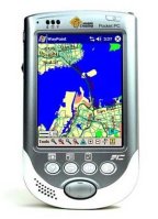
Parrot, from France, introduced its Bluetooth car kit for cell phones. No big news there, but the kit is pretty clever - it includes a GPS receiver for those who don't have or don't want one in their phones. Users then can use whichever navigation software they like (TomTom, etc.) (CTIA). There are PDAs and there are navigation systems, but how about a PDA especially engineered for navigation? (left) Mobile Crossing's WayPoint is just that, or as the marketing on the website puts it, the device "doubles as a fully functional Pocket PC." It's not yet available and I expect won't be a big deal when it is. We live in times when hardware and software are purchased separately. (CTIA) Security
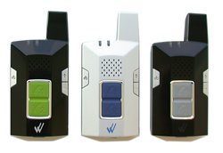
Wherify, which is merging with IQ Biometrix, showed its Wherifone G550 at CTIA. The plan is to begin manufacturing of the low cost phone, and to add additional location-based products for valuable assets, cargo, vehicles, and pets. The phone, which can save a few numbers, get located, and call 911 is expected to retail for less than $150 with monthly service starting at $15. It sounds a lot like the European phone with ears I noted a few months ago and is aimed at, among others, kids and grandparents. (Of course it's Moms and Dads that will buy it for Johnny or Grandma�) The big distinguisher of Wherify products on the locating side is that it claims its "Wherify's Location Service Center" can track the phone "within feet and inside most homes and vehicles -- without line of sight." That's in contrast to the "may" work discussion of such coverage on the company website. A new plan from Verizon allows customers who have vehicles equipped with OnStar's generation six equipment to use their Verizon Wireless phones outside the vehicle and send calls from their handheld phones to OnStar's in-vehicle calling system. Sounds like a good idea. Why not support other carriers too, to encourage the safety of hands free communication for all? (CTIA) Convenience
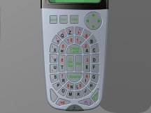
Gabrielor is hoping to change the world of keypads to be not rectangular, but round. The letters on the prototype at CTIA are in a sort of stadium design, in alphabetical order. Said one reviewer: "It did seem to work much better than � practically any other handheld keyboard." Interestingly, the mockups were demonstrated on a phone and a GPS. I hope that means industry is realizing that GPSs do demand input, though they are not necessarily communications devices. (CTIA) Nokia and VeriSign announced a project to allow cell phones to read RFID tag-based information. You might get the lowdown on the history of the oven stuffer roaster at the market or perhaps beam your data over to pay for it and check out. The prototype Nokia phone shown at CTIA has an RFID reader in its case, not in its guts. Why is VeriSign involved? VeriSign has proposed a central repository for RFID data that companies can use to relay information regarding inventories and perhaps other things.
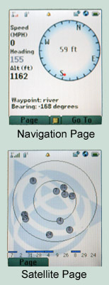
There are toolkits for everything, so why not one to manage the "vibrate" mode on a cell phone? Enter Immersion, the pioneer in haptics (the science of applying tactile sensation to human interaction with computers. - Webopedia) which released "VibeTonz Studio SDK." An article in eWeek suggests one might send a heartbeat-like message to denote love or a "kick in the pants" to denote, well, another emotion. The vibes might also be used in games, or the article suggests, as a type of feedback for navigation. The better you follow the path, the stronger the vibration. (When I was a kid we played a game like that, but used other kids' clapping as the feedback mechanism. More clapping - you are getting warmer, less, you are getting colder.) The kit runs $5,000 and that, says the eWeek columnist, will stifle uptake. I report on this, just as I learn that Billboard will begin a weekly chart of ringtones on November 6. (I am not making this up.) Would you pay 75 cents for a text message of the weather? I wouldn't, but that's yet another potential content killer app, this time from Telenor and the Weather Channel. (announced last week in press release) Entertainment Want to have your GPS-enabled phone be, well, a recreational GPS? Nextel and Trimble want to help you for a fee of $5-$10 per month. (above right) The low end service provides basic navigation and "adventure sharing" while the high end service includes map downloading and photo uploading. Of interest to at least one reader of GIS Monitor, with the software and services, a camera phone can take GPS/time-stamped images and upload them. This product/service was announced at neither show, but is aimed at the holiday gift buying crowd. I found the offering's options a bit bewildering.

Book Review: Measuring Up To be fair, that's not what ESRI set out to produce in Measuring Up: The Business Case for GIS. Authors Chris Thomas and Milton Ospina (both former colleagues of mine at ESRI) collected short profiles that describe "the business case for GIS." The 75 case studies draw on ESRI customers, mostly in the U.S., in 22 business sectors and are arranged by "the savings type:" "save money," "save time," "increase efficiency," "increase productivity,"� These are the traditional returns I've been quoting about GIS for years. While some of the studies document hours and dollars saved, others simply offer qualitative descriptions that read more like the "GIS success stories" in ArcNews (from which many are sourced) and other industry publications. None that I saw detailed how the return was calculated, something I would have found valuable. The value of this compilation, I realized, is not for us, the geosavvy, but those who have not yet seen the light. And, for that crowd, it's quite well done. It's pretty; the offerings are short; and a grid helps identify tales that might be of particular interest to a boss involved in data collection or a public sector funding provider. If Measuring Up has any flaw, it relates to the book's ESRI-centricity. Now, ESRI published the book, so I won't suggest that it should be "clear and balanced." On the other hand, I might have chosen to forego a pull-quote stating, "We've been an ESRI user for many years�so it was natural choice for our process." (p 25) That's a fine sentiment but doesn't really match the goal of the volume.

The package was supposed to go out in September (or perhaps even earlier). I noted back in April that "If funding is available, the Request for Proposal will be issued in June or July 2004 for an anticipated award before October 1, 2004." Since this document still had its edits "on" I saw September replaced with October in several places. Originally in the document, a pre-bidders conference was suggested for early October. It was in fact held yesterday. As for the other dates: the contract recipient will have three months from Jan 3- March 31 2005 to develop/integrate the portal. It'll be shown to the government on April 1, 2005. It'll go live April 4 for 9 months, and then the contractor will optionally be re-upped for up to four 1 year extensions until January 2010. The description of the new portal has lots of Open Geospatial Consortium (OGC) standards and FGDC metadata and content standards references. It's really hard to plow through and evaluate, but sounds like "a better, stronger" portal from my quick look. Proposals are due November 15.
"I have tried looking for more information regarding the academy [USGIF Academy, which was covered last week], but have found none, just press releases." The editor responds: Most new innovations begin with a press release and few details. For now, there are no further details, but stay tuned!

Points of Interest Keeping an Eye on the Flu. With the concerns over flu vaccines, it might be worthwhile to check in on this regularly updated flu map from the Center for Disease Control. You can look at the American Lung Association's Flu Shot Locator, but don't expect to find many clinics offering shots. Layoffs at DigitalGlobe. Sixty employees were laid off last week from sales and marketing positions at DigitalGlobe. A spokesperson noted that direct sales efforts were posting weaker sales than partners. Temperature Impacts Productivity. It costs more to have an employee in a colder climate than a warmer one: about 10% more according to a Cornell researcher. But, here's the even more interesting tidbit: warmer workers make fewer mistakes! "When the office temperature in a month-long study increased from 68 to 77 degrees Fahrenheit, typing errors fell by 44 percent and typing output jumped 150 percent." As someone who is always cold, that makes sense to me. Greenwich Case Continues. The state of Connecticut Supreme court has not yet heard arguments on the case pending that pits Stephen Whitaker against the town on his right to access and use the town's GIS data. But, there's much interest in the topic. Last week, the court granted a motion to allow friend of the court briefs from three groups -- The Reporters Committee for Freedom of the Press, the Society of Environmental Journalists, and Investigative Reporters and Editors Inc. Intel and Sprint/Microsoft Geo Plans. Intel is expected to add support for location-based services to its Pentium M line of mobile processors by 2006. That's the conclusion based on a senior company executive comment made on Monday. Before year's end, Sprint is expected to introduce a tracking service that uses Microsoft's MapPoint Web Service and MapPoint Location Server. It will be inexpensive, says a rep. MySQL with Geo Ships. MySQL, the company which sells services for the MySQL open-source database, released the production version of MySQL 4.1. Among other goodies, it has GIS data support. That's been available in a beta version for a while, but this is production. Views, triggers, and stored procedures are expected in V 5. NextView Award Protested. The Denver Post reports on a protest of the award of the recent NextView contract to Orbimage. New SI LLC, the name of the company that competed with Orbimage for the contract, filed the protest with the U.S. Government Accountability Office last week. An attorney has been assigned to the case and a decision is due by Jan. 28. Orbimage was told by National Geospatial-Intelligence Agency to continue its work on the contract. Orbimage feels the protest is without merit.
Kudos and Conundrums Kudos (concepts we applaud) RFIDing the Past. HP Labs RFID Demo Center opened for a tour earlier this week. While there were many RFID demos, including ones focusing on sensors, one caught my attention: a system that tracks the movement of tagged items. Code-named SmartLocus, the system uses a video camera to keep track of what went where and how fast. Accessing the system, a sort of geohistorical database using WebSign, which combines GPS, a compass and a tilt sensor into a handheld device, a warehouse worker might be able to point and ask, "What was here recently?" Off the top of my head such a system would be useful for "traffic" (the warehouse type of traffic) and for tracking potential contamination. Conundrums (concepts we question/give us pause) Modeling Combat. The U.S. Joint Forces Command with help from The University of Southern California techies has developed a supercomputer-driven simulation of a continent on which to build battlefield simulations. It is aimed to simulate war 11 years in the future and include more than 100,000 different soldiers, civilians, vehicles, etc.
Please note: Material used herein is often supplied by external sources and used as is. � Announcements Frost & Sullivan announced Autodesk, Inc. as the recipient of its 2004 LBS Innovative Product Suite of the Year Award for the company's comprehensive location-based service (LBS) solution. Autodesk, Inc. and Agilent Technologies Inc. announced an agreement to jointly market the first interoperable location-aware solution for the telecommunications industry. Wireless carriers will now be able use the Autodesk LocationLogic middleware platform and Autodesk's suite of location-enabled applications together with Agilent's acceSS7 Location network-monitoring technology. As I understand it, interoperable here refers to the two products working together. In another announcement, wireless service providers in North America can now license NAVTEQ maps directly from Autodesk for integration into its location platform and software. UCLID has launched a campaign to upgrade AutoCAD and Windows IcoMap users to the ArcGIS extension. Terra Image USA, LLC has been named the exclusive distributor of SPOT satellite imaging products and services to the U.S. civilian government market, including federal, state, and local government entities and U.S. universities. Terra Image USA is a joint venture of The Montecito Group and Iunctus Geomatics Corporation. Terra Image USA's Chairman, Joseph T. Gorman, is the former Chairman & CEO of TRW and also Chairman of The Montecito Group. Health and Human Services Secretary Tommy G. Thompson announced 21 grants totaling $230 million over five years to implement the Strategic Prevention Framework State Incentive Grants to advance community-based programs for substance abuse prevention, mental health promotion, and mental illness prevention. At least one involves GIS: Kentucky's Strategic Prevention Framework Incentive Grant project will build a data-driven, comprehensive, interagency prevention service system to reduce substance abuse and its related problems. The state will make extensive use of geographic information system (GIS) technology to focus community goal setting and enable targeted resource allocation. � Contracts and Sales The Harrison County, Ind., Commissioners recently selected Woolpert LLP to provide a digital terrain model (DTM) to support a storm water study as well as the Federal Emergency Management Agency's (FEMA) map modernization project. NAVTEQ has been selected as a map data provider to Pharos Science & Applications, Inc. Definiens Imaging and PCI Geomatics signed a three-year eCognition educational site license with OhioView, a statewide program that focuses on satellite remote sensing data, and technologies in support of applied research, K-16 education, workforce development, and technology transfer in Ohio. Norrk�ping, Sweden has decided to migrate its Sysdeco chart database to Windows. The project has a value of approximately 3 million Norwegian Kroner (over �250,000). � Products MapInfo Corporation launched StreetPro Thailand, a street network database for the Kingdom of Thailand. The Sidwell Company released of Parcel Builder a set of tools for use in ArcMap 9.0 by ESRI. Autodesk announced Autodesk Crisis Command 2 software, enhanced to provide even greater capabilities for emergency managers. It's built on MapGuide. @Road, Inc. a provider of mobile resource management (MRM) services, has introduced @Road Mobile HotSpot, a Wi-Fi device that can transform any vehicle into a mobile hot spot. ObjectFX announced it has created a Micro Edition (ME) of its SpatialFX platform. This new offering will enable developers of rich content for small wireless device applications to quickly develop interactive maps and other location-enabled services directly within these devices. � Events The seventh ESRI Middle East and Africa User Conference is scheduled for December 7-9 in Dubai, United Arab Emirates (UAE). Ecobuild America premieres in 2005 at Disney's Coronado Springs Resort and Convention Center in Orlando, Fla. It runs concurrent with recently announced AEC-ST. Both run June 20-23, 2005; and exhibits are open June 21-23, 2005. Ecobuild keynote speakers will include Jack Dangermond of ESRI. Laser-Scan boasts its user and partner conference had "more than double the number of delegates from last year." ESRI-Boston will hold its annual Open House on November 9 from 9:00 a.m. to 4:00 p.m. at its office in Danvers, Massachusetts. This free event is open to ESRI software users, and business partners as well as those who are interested in geography, maps, and geographic information system (GIS) technology. Last year, more than 200 people attended the Open House, and because of that success, this year's event will be larger in size and scope. Details and RSVP info here. � Training � Hires
FORSight Resources, LLC, a provider of decision support services for natural resource management, announced several new hires: Greg Day, Karl Walters, Ian Prior, and Bill Guiffre. NAVTEQ announced that Christopher B. Galvin, former Chairman and CEO of Motorola, and William L. Kimsey, former Global CEO of Ernst & Young, have been elected to the NAVTEQ Board as Chairman and Director, respectively. DM Solutions Group Inc., a Web mapping solutions company, announced the appointment of Mr. Kim Tofin as vice president of business development.
Advertise With Us
Contact GIS Monitor is published by: GITC America, Inc.
Subscribe/Unsubscribe |