Points of Interest, Week in Review (Announcements, Contracts, Products, Education, Events, Hires) Back Issues, Advertise, Contact, Subscribe/Unsubscribe If, for some reason you cannot read this document, visit: http://www.gismonitor.com/news/newsletter/archive/103003.php
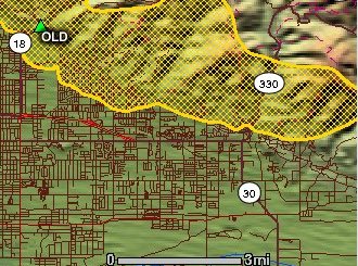
MAPPING THE CALIFORNIA FIRES On Monday I surfed the Web looking for simple maps of the California fire locations. After a far from exhaustive search, I found just two: one in the New York Times (free registration required) and one in the San Francisco Chronicle (sourced to AP/ESRI). CNN, which usually is right on top of maps, had none that I found. I received a note that day (thanks to Diane at TenLinks) pointing me to satellite imagery at the San Diego Union-Tribune. On Tuesday ESRI sent out a link to its webpage of resources. It's a very extensive list of response websites, fire websites, Red Cross information and more. The GeoMAC website was experiencing a high hit rate and had a warning about its slow map drawing on Wednesday, as I wrote this. ("The Geospatial Multi-Agency Coordination Group or GeoMAC, is an internet-based mapping tool originally designed for fire managers to access online maps of current fire locations and perimeters in the conterminous 48 States and Alaska." It's built on ESRI's ArcIMS. The image above was captured on Wednesday.) Over at GeoData.gov there is a "Fire Channel" that alas provides no real time GIS data service of the fires, but does offer basemaps for the areas in question, a link to CNN, and links to video loops of the fire.
I'm hopeful as technology advances and Web services mature that it will be possible to overlay many of these data sources together in real time. For this fire, the closest thing is a simple application from GeoMicro that geocodes an address and shows its location relative to the fires. The fire data is from NASA, but it's not provided as a service, so the GeoMicro team had to concoct a way to grab the new images as they became available. I'm impressed with this solution for a few reasons. First, it uses data that is tough to find and use. Second, it's fast. Third, it provides exactly the information people need (data in context, which causes action).

NEW ENGLAND GITA FALL MEETING: THE USE OF IMAGERY WITH GIS The opening session covered "Aerial Imagery 101." I was looking forward to a refresher since I took exactly one course on remote sensing in grad school. It helped me to be reminded that a pixel is simply the smallest unit in an image that has "one color" and to remember that when using film you need to be concerned with both the film resolution and the scanning resolution. On the other hand, a few comments left me confused. First, when speaking about the clean room where the film is scanned, I heard that "positive pressure is maintained so dust doesn't move around." I thought back to the organic chemistry lab where I once worked where we used positive pressure (a system that forces air out of the room when you open the door) to make sure contaminants didn't come in. I suppose that if pressure is applied and the door isn't opened, it might keep dust from moving as much. The presenter didn't mention digital sensors, and a response to a question about the resolution of such devices noted that "it's hard to get down there." I know of a digital sensor with 6" resolution (and of course in a plane you can fly very low and increase resolution even further). I was most concerned about the response I received to my question about the difference between a Digital Elevation Model (DEM) and a Digital Terrain Model (DTM): "A DEM is less rigorous." Other attendees explained the difference this way: DEMs have no "breaklines," while DTMs do. I found this definition at the Pima County Arizona website: A DTM is a DEM where "breakline" data has been added (breaklines are lines in the topography where grade changes exist, such as tops and toes of slopes) and points have been removed for polygons or other dense features. Next up was a primer on satellite imagery. Again, I took away a few tidbits (which all apply to Space Imaging since the presenter was from that organization). IKONOS crosses the U.S. three times a day, but hits every point on the globe (in the same orbit) every 140 days. That said, it can hit any point within one to three days. How? It's because most shots are not "straight down" (at nadir) but taken at an angle. From that distance that angle covers a lot of area. If you want one-meter accuracy, you may need to wait for up to three days. I learned that Space Imaging "subscribes" to "Open Skies," a treaty set in motion by President Eisenhower. In layman's terms the agreement translates, "If we can fly over it, we can take pictures of it." That said, the U.S. Government does have a say as to whom the company can sell its data. I learned that linear features are more visible in satellite images that non-linear ones. What that means is that parking lot lines may be visible on one-meter imagery (that is, you can see things that are a meter in size) even though they are not a meter wide. I learned that 11-bit data is eight times more sensitive than 8-bit data. Said another way, in 8-bit data, the gray scale is divided into 256 "colors." In 11-bit that jumps to 2048 "colors," allowing you to tease out more information in, for example, areas of shadows. The good news is that most image processing software is now 11-bit so users can get quite a lot out of their data. I asked about when one would use satellite imagery as opposed to aerial imagery. I realize this is a "novice" level question, but it's a pretty important one, especially for Satellite Imagery 101. One part of the reply was quite memorable: "we [satellite vendors] deal with counties, not shopping centers." Another question brought up why the great promise of imagery for agriculture (from aerial or satellite-based sensors) never played out. (Several companies that focused on that market have gone under or changed their focus.) To be useful for agriculture, the presenter noted, the data must be captured daily or weekly, not weekly or monthly which is a far more realistic and economic schedule for both aerial and satellite platforms. Another questioner asked about the lifespan of IKONOS. The satellite's original lifespan was expected to be five years, but three years into its trip, its caretakers have extended that life to seven years. The speaker was quick to point out that Landsat 5 is in the 19th year of a three-year life expectancy. Part of the reason for these extended life spans makes good sense: once the bird is in orbit there are only a limited number of things that can cause it to "break." Alas, one of those seems to have happened to Landsat 7. (Like kites, while they are in the air it's pretty tough to break them, but during launch or landing the probability of damage rises dramatically.) Another attendee inquired as to "how current" customers prefer their satellite imagery to be. It turns out that "anything over a year old is worthless." To be sure, data for change detection is in demand, but in much smaller quantities than new data. The next presentation was by Meteorlogix - the company I know as a provider of a weather data service available via ESRI's Geography Network. What's interesting is that while weather data typically starts life as imagery (satellite, radar, etc.) it is typically delivered as vectors. Meteorlogix doesn't "make" weather data, but collects, processes, and disseminates it. I figured we'd be talking about hurricane prediction and other catastrophic events, but one of the most valuable data sets is lightning strikes. Many electric utility companies pay for notification when strikes happen. Others use Meteorlogix to grab historic data to determine if indeed an outage was caused by a strike. The most interesting application was one used by Union Pacific Railroad. High winds can blow trains off the tracks - particularly empty trains - and cause damage to both cars and tracks. Damage is far worse if the train is moving. So, Union Pacific uses Meteorlogix data to predict where high winds will hit a train. In these situations the crew stops the train. To date Union Pacific has saved a projected $6 million. Dick Cohane, Business Integration Manager at NSTAR, took to the mike after lunch. Cohane is well known in and around Boston as the person behind Boston Edison's imagery work during the 1990s. He reviewed the role of imagery as NSTAR expanded. (NSTAR is the current owner of Boston Edison and a handful of other electric and gas utilities.) Cohane was genuinely disappointed that the company hadn't yet been able to work more closely with the state or other players since he highlighted the value of data sharing and described it as a "win/win." "We are all scattered all over the place, p*ssing money," as he put it. The good news: one GIS player from the City of Boston immediately asked how to work with the company on data sharing. Cohane's final comment was particularly telling. He noted one big error in GIS development over the years: "We focused too much on technology and not enough on culture in the workplace." The highlight of the day was a panel discussion titled, "The Future of Imagery and GIS." I hope to cover the discussion in a future issue.

uLocate: TRACKING AS SERVICE, NOT "BIG BROTHER"
uLocate is the brainchild of three entrepreneurs, all with experience in "applied technology" solutions. The idea of taking advantage of cell phones' soon-to-be supported location awareness seemed to them to be a natural business to explore. Their logic goes this way: if there are 150 million phones in use in the U.S. growing at about 15% per year, and in time, they are all location-aware, if 1% of users tap into location-based services at $5 a pop, the money adds up very quickly. The company began development last November and started going public with its service in the last few weeks. I saw a press release about the company's current offer of free service and noted the address was just outside Boston. I was invited out for a demo a few weeks ago. uLocate's system is GPS-based. That means it supports only five phones: two from Benefon (a Finnish company) and three from Motorola. The newest Motorola phone, introduced in the last two weeks, is a big step forward in that it automatically loads the required Java application. On earlier models it has to be manually loaded by choosing an option on a menu.
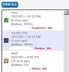
Partner Alan Phillips pointed out that nearly all location queries can be done right on the phone - there's no requirement to find a Web-enabled computer and boot up a browser. Of course you can do that if you wish should it be more convenient. He feels that the phone will ultimately be the way most users - home or business - will be using the service. So, using the phone, he illustrated a group (a number of people who want to keep track of each other, in this case, some of the company staff) and we checked on their locations. The phones send out location information every two minutes via a data packet on the wireless service. The latitude and longitude pairs are reverse-geocoded by MapQuest (uLocate licenses the technology and runs it on a local server) and displayed on the phone as text, or alternatively, on a map. Above, are the locations of several of the uLocate staff members on one particular evening. The map above shows them, too.
We took a look at Phillips' recent geographic history and saw the route he took from his home to work. Twenty-seven dots marked the route and correctly showed the roughly one hour ride to the office. The system can also interpolate the route and show a single linear path ("connecting the dots"). At left, for example, is bike rider Drew's path in Tennessee, part of a trip across the country. The data held on the server goes back 90 days, so it's possible to know where Phillips was on say, Labor Day. History, while perhaps interesting for family use, is more likely to be of use to businesses. For example, did the delivery person show up on time within the hours when the refrigerator was promised? Typically, when I think of "tracking," I picture someone keeping tabs on the whereabouts of a person and/or vehicle. In point of fact, Phillips noted, that's not how the service is used in practice, at least around his house. He has a teenage son. The phone can let Phillips know when his son's soccer team has returned to school after a late game so that he can go and pick him up. He can get alerts when his son gets home from school. uLocate uses the term geofence to identify a buffer around a point. Alerts can be set up to send messages (SMS, or e-mail for example) when a particular phone passes into or out of an area. One burning question I've had of all GPS-based location devices, especially for children, is what happens when they go inside and there is no signal? The answer in the uLocate application is that the system shows the phone's last successfully delivered location, likely just outside a building. And, when the child leaves (goes back outside) the signal picks up again. As Phillips puts it, "I'm not so concerned about my son is when he's in school, but I like knowing when he leaves. It's just a service that makes my life easier." About half of uLocate's 200 current users are families. The rest are small businesses that keep track of traditional fleetss, like tow trucks and delivery vans. Why would a fleet maanger choose a phone location solution over a solution attached to a vehicle? Phillips noted that embedded dedicated GPS boxes for fleet tracking typically run about $1000. The hardware costs for cell phones are roughly zero, since practically everyone carries one. (And, in time, they'll all be locatable, though not necessarily using GPS.) For now uLocate's service can be tested for free, but come next year the pricing plan will run $12.95/month for the first phone and $9.95 for each additional phone, with discounts starting at six phones. Down the road the uLocate team imagines a freely available "where am I" platform with optional services that users can pick and choose from an extensive menu of options (find the nearest ATM, routing, etc.). Frank Schroth, one of the other partners, feels strongly that we need to see the "big brother" aspect of this technology as two-sided. Certainly it can be intrusive and used in questionable ways, but "big brothers can also be called upon to keep children safe. We need to see location-based services as simply that, services that make our lives easier and safer. Or in the case of business, services that help insure customer satisfaction and provide more profit."

BRINGING 3D TO GIS OR GIS TO 3D?
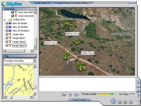
The company, which was recently purchased by PlanetGov Inc., initially focused on computer games and moved into some consumer applications with its 3D visualization tools. When the company developed a strong base in the military (like the tanks on the terrain above), it dropped the gaming side. Even with a focus on military users, the company maintained a loyal following worldwide in local government, architectural, and real estate applications. Skyline is a longtime Oracle partner and was the first company to support the new geospatial tools, specifically imagery tools (Spatial GeoRaster), in Oracle 10g. In fact, Skyline's technology was demonstrated onstage during the rollout of 10g at OracleWorld last month. The application showed a realistic view of San Francisco, real estate data, thematic layers such as the location of wireless hotspot, all brought together to help locate a luxury hotel. The big advancement for Skyline recently was the addition of TerraBuilder DirectConnect, a tool that allows real time use of imagery and models in their native format (from Oracle Spatial for example) to be delivered to different client applications (desktop, PDA, etc.). Before this solution, the data needed to be preprocessed before it was streamed.

BENTLEY EMBRACES PDF
The most recent version of Adobe Acrobat added support for AutoCAD and its layers. The plan now, with Bentley's help, is to optimize it further for AEC workflows. While Adobe claims that PDF is the de facto standard for electronic engineering design sharing, I've heard only anecdotal support for the claim. I don't think that means the claim is in error, but rather that there are few other options. Moreover, as Brown pointed out, so many other types of documents used in the AEC workflow are also converted to PDF (specifications, forms, etc.) it's tough to tease out drawings alone. It seems to me that the big difference between the Bentley/Adobe approach and that of Autodesk, is that the pair is looking at a solution that covers not just drawings, but "the greatest number of document types throughout the project life cycle." (I heard that three times in my 20-minute call, so it must be important.) That aligns with the idea that the PDF solution is for data creators and consumers, and that data required for this "project level sharing" goes beyond just drawings and includes other materials. I did ask the same question I asked of Autodesk DWF advocate, Tony Peach earlier this year: what's in it money-wise for Bentley? I got the same answer: "We are responding to customer demand." Even as Adobe, Bentley, Bentley customers, and others provide input into the future of PDF, Bentley has licensed the Adobe PDF Library and will include support for the format in the next version of Bentley's 8.5 release of MicroStation. The PDF-enabled discipline-specific applications and collaboration servers are due out in 2004. That means that all of Bentley's desktop creation products and its server products (ProjectWise, for example) will be able to create, search, and navigate PDF without additional software. Two things strike me about this announcement. First, back in the early days of CAD and the Internet, Bentley jumped into the fray by licensing some technology to include an Internet browser (MicroStation Link) inside of MicroStation. It was not clear at the time whether browsers would be a part of operating systems, but the company wanted to be on the cutting edge. Dyer reports that the "technology that we originally licensed was SpyGlass' WTK (Web Technology Kit), and what that provided (basically) was Web browser emulation within our products. We have since foregone the WTK and now take advantage of Internet Explorer either as a child process [a process created by another process -Ed.] within MicroStation or linked as an external process. HTML Author uses this, and we support both HTTP and XLink (XML) linking within DGN files." Part of me can't help but wonder if Adobe Acrobat (or something similar) might ultimately become part of perhaps not the operating system, but a separate utility toolset. Second, CAD must surely be mature if vendors (Bentley and others) are looking to invest in this type of challenge that, at least now, appears to deliver no direct profit.

DATA TIP This week's tip: 2002 TIGER/Line Files & Free Translation Tools The TIGER/Line files are extracts of selected geographic and cartographic information from the Census Bureau's TIGER database. These data are freely available from the US Census Bureau in ZIP compressed format. There is one TIGER/Line file (in a compressed format) for each county or county equivalent. The Census Bureau produces the TIGER/Line files in ASCII text format only; therefore, the data are not in a common GIS format. Don't let this discourage you! Translation tools are plentiful. Users not necessarily needing to translate the data might consider using the LandView viewer and the TatukGIS Viewer which both support the TIGER format. Looking for SHP format data? The Bureau is making the detailed UA/UC boundary file available to the public at the national level in ArcView Shapefile (.shp) format. The boundaries in this file are an exact match of the boundary details found in the UA Census 2000 TIGER/Line files. Users searching for free Census data in MIF or SHP format may be hard-pressed to locate these data for free, however, a number of commercial data providers can be easily found on the web. Finally, users wishing to translate the raw data for themselves can attempt to do so with a free tool called TiVec (short for Tiger to Vector Conversion Program).

POINTS OF INTEREST GIS? ZDNet UK has a long and detailed article about the technology progress of the Ordnance Survey. I guess they know more about GIS in the UK as the article title and text mention "GIS," with no explanation. Tracked Plows are not Happy Plows. Here in Massachusetts the Highway Department has decided to put GPS devices in contractor's slow plows starting November 1. The cost is roughly $300,000 for 2,900 GPS-equipped Nextel phones at $90 apiece. Some contractors resent the intrusion, saying they've been doing good work for years. Others say they have nothing to hide, but hope the State will not take advantage of the devices to dock workers for a coffee break in the truck. There was enough dissent, however, to create the Massachusetts Snow and Ice Contractors Association. The group advised its members to hold back on renewing contracts until the State responded to its concerns. Free Wi-Fi Turns Profit. More and more cafes and hotels are offering free wireless access. Some suggest that the free amenity (which some argue parallels the pay toilets once found in many restaurants) helps draw customers and boost profits. While Starbucks still won't talk about its return on Wi-Fi, Schlotzsky's reports an additional 15,000 visits per restaurant per year totaling more than $100,000 per year per outlet in return for an investment of about $8,000 per restaurant. Tasty! GPS Care Package. Families of Canadian military personnel currently in Afghanistan are annoyed that the government is not providing GPS receivers. Instead, families are buying and sending the devices overseas. Defense Minister John McCallum responds, "I would think that, similarly for radios, not every individual needs this." Lights at Night Measure Sprawl. Paul C. Sutton, professor of geography at the University of Denver, has measured urban sprawl in cities with more than 50,000 people and listed the top and bottom sprawlers. Midwest and Southern metro areas are still sprawling while California and the East are more contained. The paper titled, "A Scale-Adjusted Measure of Urban Sprawl Using Nighttime Satellite Imagery" appears in Remote Sensing of Environment. I didn't find it online, but I did find its abstract; the paper will be presented at the Association of American Geographers meeting in March in Philadelphia. Sutton used nighttime imagery and regression to compute the nation's "sprawl line," the average relationship between the geographic extent and the population of urban areas in the United States.
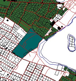
A MapServer for Tonga. The South Pacific Applied Geoscience Commission (SOPAC), with funding from the European Union, is developing several map servers for island counties in the South Pacific (Fiji, Kiribati, Papua New Guinea, Samoa, Solomon Islands, Tonga, Tuvalu and Vanuatu). A pilot in Fiji was underway in August. This week the server for Tongo went up. Tonga, by the way, is the only South Pacific country never to have been colonized by a foreign power and maintains a constitutional monarchy. I explored the server and found some very detailed data. The gray parcel seems to belong to the king. The technology? Open Source Mapserver, Linux and TwikiWiki (an open source environment for coloration). At right, some of the land (blue) owned by the king of Tonga. What's Not Happening. Michael Kanellos, writing at CNET has a very interesting article covering "things that may not happen." In it he explains why some of the things that have been rumored to happen, have not happened, and why many never will. A few are particularly pertinent to the geospatial market and to what I do. He explains that while services (and he means selling people's expertise, not Web services) are supposed to be where the money is, in fact, it's not. The margins for services - as noted by IBM, which is now a big player in services - are lower than hardware, software, and several other aspects of the business. He points out how with services you can bargain down prices since there's no "stuff." He also says that while cost of a software product drops rapidly once it is complete, with services you still have to hire "men and women to run around in blue suits to provide company presentations." He suggests that while the planet likes to think that "Websites [and I'll add publications] tailor their content to suit advertisers" it's not that way. He notes, that if that was the case, those who work on them wouldn't be "living in abject squalor." ESRI and PeopleSoft. ESRI and PeopleSoft have tightened up their relationship to add all of ESRI's products to PeopleSoft's Guardian solution aimed now at first responder recruitment, skills assessment and deployment. According to a story at FCW, users can "model the progress of incidents over time, determine bottlenecks and delays such as transportation roadblocks, provide demographic analyses of situations and better meet asset needs." PeopleSoft's Raymond Vigil, director of business development in the company's education and government division, notes that first responders are still working on getting fire trucks and radios but will soon find the need for location. New Addresses for Bangalore. Structures in and outside the city of Bangalore are getting new addresses as a new GIS is put in place. Now, the addresses are nearly random and can't be used for general information or taxation. The new addresses will be correlated with old ones for some time, but will eventually be the only address. Funding for the project, which includes 31 other areas across the state, comes from the World Bank. A pilot project showed significant tax revenue increases after mapping and new addresses were created. Cool Historical Maps of Taiwan�Unavailable. A new GIS is the result of a two-year research project funded by the National Science Council (NSC) in Taiwan. The online system includes data from different eras and includes hundreds of basemaps, topographic maps, geological maps, census maps, and historical maps. The resource is not yet public, since the developers are still sorting out intellectual property rights. Geolocated Photos. World Wide Media Exchange, a project of Microsoft Research's Interactive Visual Media Group that allows people to post photos and their coordinates announced just last month that it now holds 20,000 photos. One goal of the project is to sort out technical details, like how best to geocode photos; another is to figure out if there's any reason (consumer or business) to do this. The demo is built with MapPoint .NET and provides a map with dots where photos are available. There are about nine images in and around Boston. GeoSnapper.com has a similar idea. The Geography of Dogs. I'm not a dog person, but the New York Times (free registration) has an interesting article highlighting some research into the distribution of dogs in the city. Of particular amusement is a map based on the Zip codes of registered dogs (likely about 20% of all dogs in the city). It shows which breeds are most popular where. Sole Source Imaging. It's looking pretty good for a sole source contract for imaging Leavenworth, Kansas. The city public works director, mayor and others want to take advantage of a past relationship with M.J. Harden to avoid a new firm's "learning curve" on the project. But the Mayor Pro Tem noted he's not comfortable with sole source, asking, ""Why aren't we bidding?" A Picture of Every Building. Vermont-based microData GIS Inc. will begin taking pictures of the fronts of all residences and buildings in Wayne County, Indiana this week. The plan is to use the images, their addresses and coordinates collected, in emergency response situations. The cost: $158,620, some of which may be reimbursed by the Indiana Wireless Enhanced 911 Advisory Board. Makes me wonder which type of imagery - obliques, front of building shots, IPIX 3D shots or something else - is most cost effective and useful to first responders. My sense is that any one of them is better than nothing, certainly, but are there guidelines as to how to spend money? MapQuest Explains Journalism. A Stanford University grad student in journalism makes the argument that modern journalism has been derailed by its objectivity. The analogy he uses points out that an algorithm similar to that of MapQuest's routing underlies current reporting, creating roughly the same story in each paper from the same facts. It Takes (at least) Two. The National Imagery and Mapping Agency's (NIMA) director was frank about the need to support at least two commercial satellite imaging companies in a statement this week. "This is sort of an insurance policy, a back-up to support or buttress our work," said retired Air Force Gen. James Clapper. Web Mapping for PHP. Simon Moss has a new article, "GIS Mapping with PHP." It's a very basic look at how to plot a point on an image map, but it's a fine start for those getting their feet wet with Web programming or PHP. I especially like this part of the intro: "For this article you will need: PHP with GD installed, A pair of scissors, An adult to help you." GIS Day Plans. I will have the privilege of giving the keynote address at Ventura College's celebration of World GIS Day to be held on November 21. I'll be speaking on "What Web Services Will Mean to GIS." I want to send special thanks to GIS Monitor readers at the college and county for inviting me. Quote of the Week. "GIS is the best tool that geographers have created since the map itself." Dr. Joseph Kerski of the U.S. Geological Survey in a news story about students at Bishop Dunne Catholic School's use of GPS and GIS.

� Announcements According to GITA, a total of 579 people attended GITA's 12th Annual GIS for Oil & Gas Conference Sept. 29-Oct. 1, in Houston, Texas. The total attendance fell just short of the previous year's record total of 588, but user registrations for the conference increased by more than 10 percent from 2002. Total paid registrations for the 2003 conference also increased 11 percent from 2002. Got that? Telcontar announced an agreement that enables the company to resell GlobeXplorer imagery services. Under the agreement, Telcontar is now able to offer GlobeXplorer's high-quality aerial and satellite digital images to customers using either its Universal Telematics Server ASP or Drill Down Server spatial platform. Globalis is a tool which highlights the similarities and differences between the countries of this world, and has been developed by the United Nations Association of Norway in cooperation with UNEP/GRID-Arendal, the UNU/Global Virtual University and the University College of Hedmark. Globalis uses the UN Millenium Goals as a starting point, and will follow the development towards the year 2015, when, according to plan, these goals of human development and poverty reduction should have been reached. The tool also includes data from different years, allowing you to see, for instance, how humans have influenced the environment over time. China has committed 200 million euros to the European Union's Galileo satellite project. Brooklyn Economic Development Corporation announced Destination Brooklyn, an interactive Web-based map that offers detailed real estate and demographic information for every property and neighborhood in Brooklyn. The Open Data Consortium, a public-private partnership project funded by the USGS and private companies, has developed a model data distribution policy for guiding local government dissemination of public-record geodata. It's available for download on the organization's website. The International City/County Management Association (ICMA) launched a moderated GIS/IT electronic discussion list available to members. Details here. ObjectFX announced that it has integrated its SpatialFX tool under the name TrackingAdvisor with QUALCOMM's FleetAdvisor fleet management system. Geosoft (Korea) entered into a mobile GIS content supply agreement and received an investment of 200 million from MTI last month. Geosoft expects to make 3 million dollars or more in income for the next five years by supplying the mobile GIS content to MTI. GlobeXplorer LLC, a distributor of online aerial and satellite imagery, announced an agreement to provide Terraserver.com access and distribution rights to their full library of high-resolution earth imagery. Andrew Updegrove, a founding partner of Lucash, Gesmer & Updegrove (LGU) was awarded this year's Mass High Tech All-Stars Award in the legal category. Updegrove was honored for his work with standards organizations. He is also the founder and editor of ConsortiumInfo.org, the source of information on the Internet regarding consortia and standard setting. There's also a new blog there that's pretty interesting. Updegrove isn't a GIS guy per se, but he and his firm do work with the Open GIS Consortium. A press release from LizardTech, Inc. notes that the company "has been named to the Technical Committee of Open GIS Consortium, Inc." So far as I know there's no "naming" of members to OGC. It's like the YMCA: you pay your money and you are a member. Trimble announced results for its third fiscal quarter ended October 3, 2003. The Company reported third quarter revenues of approximately $139.6 million, versus approximately $114.7 million in the third quarter of 2002, exceeding expectations. Garmin's third quarter revenue increased 26 percent to $135.6 million from $107.8 million in the same quarter last year. The company increased its guidance. � Contracts and Sales The Forestry Division of the Wisconsin Department of Natural Resources and the University of Wisconsin have used the TatukGIS Developer Kernel (DK) toolkit to create the Forestry GIS (fGIS), a free, basic GIS data viewer, digitizer and shapefile editing program for Windows. The fGIS software is designed for resource managers who want to make land cover maps for management plans, timber harvests, reforestation or other projects. Trimble announced that T-Com, Deutsche Telekom's fixed-network division, one of the largest fixed network providers in Europe, has awarded a contract to Trimble for the purchase of GPS survey equipment and software. The equipment will be used to collect accurate position data of T-Com's telecommunications network infrastructure assets across Germany. Financial details of the contract were not disclosed. Anne Arundel County, Maryland has purchased four seats for NovaLIS' Parcel Editor for ArcGIS 8.3 to manage the county's parcel fabric. The county will use Parcel Editor and ArcGIS to maintain more than 300,000 property boundaries. MapQuest and U-Haul International, Inc. signed an agreement that integrates MapQuest's location-based maps and locator services on www.uhaul.com. � Products TerraSim announced TerraTours 3D GIS viewer. TerraTours provides access to a variety of Web-based media including audio, video, still images, and Web pages, presented as graphical links in a real-time 3D display. In addition, all geospatial attribution present in the source vector data used to construct the 3D visualization is available for query and display. The Management Association for Private Photogrammetric Surveyors (MAPPS) released the 2003 "MAPPS Non-Cash Benefits and Salary Survey." This survey provides a comprehensive overview of the major salary data and benefit programs for eight pay levels for technical positions from entry level through middle management. It is available for sale to MAPPS member firms for $250, and to nonmembers for $500. GPS-Photo Link software, a program that automatically matches digital photos with their GPS coordinates without any wires, is now compatible with Magellan GPS receivers. GAF AG, has developed the system components of the Agricultural Area Information System LAFIS in response to EU guidelines concerning the mandatory implementation of GIS technology. It's a suite of products that links to data, servers, or ArcSDE. GeoConcept announced GeoConcept G5.5., an updated version of the GIS engine that is central to all applications developed with GeoConcept and GeoConcept Internet Server V3 (GCIS V3), the third version of GeoConcept Internet Server for enterprise networks and the Internet. Enhancements in both products support user-friendliness and productivity. � Education and Training � Events Intergraph Mapping and Geospatial Solutions and the Intergraph GeoSpatial Users Community (IGUC), announced an Intergraph Geospatial Software Symposium to be held in Mississauga, Ontario, Canada, on November 13, 2003. � Hires and Appointments
ADVERTISE WITH US
CONTACT
SUBSCRIBE/UNSUBSCRIBE |


