Letters, Points of Interest, Kudos and Conundrums, Week in Review (Announcements, Contracts, Products, Events, Training, Hires) Back Issues, Advertise, Contact, Subscribe/Unsubscribe If, for some reason you cannot read this document, visit: http://www.gismonitor.com/news/newsletter/archive/110404.php
A Single Grid
The National Geodetic Survey (NGS) explains the value of USNG this way: "The national grid will improve public safety, commerce, and aid the casual GPS user with an easy to use geoaddress system for identifying and determining location with the help of a USNG gridded map and/or a USNG enabled GPS system." NOAA even provides conversion tools. The grid is in use already. An article in Fire Chief Magazine from this summer points to The National Map (above) and HazardMaps.gov as websites that support the grid and notes the "military version," Military Grid Reference System (MGRS), which is interoperable with USNG, is taught to new army recruits. The Fire Service Needs Assessment estimates that about 1% of fire departments currently use the MGRS and reports that several GIS vendors support the grid in their software. The big push from public safety revolves around interoperability. Local grids are not accessible/familiar to responders from other geographies. Latitude/longitude can be expressed in at least three different ways, suggested one article, leading to confusion. The other article I read, by VP and Chief Technology Officer at NAVTEQ, Salahuddin Khan suggests "a comprehensive Europe-wide location-inclusive postal code scheme" called the European Geographic Ordinate (EGO). It would eliminate the need for geocoding, he notes. It's a bit of a different vision, but has some interesting ideas. In particular, adding coordinates for height, which takes care of identifying locations in buildings with multiple floors. Several times Khan notes how such a system will put Europe ahead of other regions in issues relating to location and location-based services. And, I read the regular announcements about the adoption of NAC Geographic Product's Universal Address System, yet another grid square-based scheme. So, why is it that in 2004 we still don't have a single, worldwide solution for delivering mail, providing location-based services, and supporting first responders from other geographies? The problem is not technology, nor ideas, as these three visions suggest. The problem, like so many, revolves around bringing together the different players to agree to a single solution that will work "well enough" for each purpose, in each geography. I guess we are not there yet. Still, I'm heartened to read about these efforts both as a user of GPS and citizen of the planet.

Let's start with a review. Google is just great. I use it daily and frankly could not write this newsletter (and meet my other responsibilities) without it. (If you don't yet have the Google toolbar embedded in Internet Explorer, I strongly suggest downloading the freebie.) Google is also a darling on the stock market. The company went public in August and its shares have doubled in value since. Google is expected to bring in $1 billion in net revenues this year with about $250 million in profit, according to the company's Initial Public Offering filing from April. Since 1992 (the company was founded in 1998), advertising has provided more than 92% of revenues for the company. Of that ad revenue, more and more is coming from ads on other organizations' websites, rather than Google-owned sites. This year about 22% of ad revenues were from outside websites, vs. 0 in 2001. Acquisitions Google acquired Applied Semantics in 2003 for $102 million. The company provided domain name, contextual advertising, and enterprise search solutions. It was a key partner to pay-for-placement search engine Overture. In fact, Applied Semantic created AdSense, now Google AdSense, which puts the ads noted above on those outside websites. Google also took over failing DejaNews, a Web interface to USENET groups, which I couldn't do without a few years ago. These days Google Groups, as the technology is now called, has become less vital to me, in part, because USENET groups related to geotechnology are not as strong as they once were. Google also bought: Outride, a personalized search company. Pyra Labs, the company behind the popular Blogger.com weblog creation tool and Blogspot, a weblog hosting service. Kaltix, a start-up company of three, which also focused on personalized search tools. Sprinks, the former paid listings division of PRIMEDIA's About.com. Picasa Inc., a digital photo management company. Neotonic Software, an email software company. After the IPO, the folks at Motley Fool predicted purchases of such companies as AskJeeves, Monster, Overstock, and Priceline. There was no talk of buying "content websites" which may be where Keyhole falls. On the other hand, Keyhole is a service, like Google's still-in-beta Gmail, and upcoming desktop search offerings. There are those who feel that all Google acquisitions somehow benefit from search and/or provide more places for advertising to be displayed. I supposed Keyhole could enhance both at some level, and of course, provide a platform for location-based advertising. Content Let's go back to the idea of content. Google picked up DejaNews and its archive of past messages. Word is, Google took a few hard drives to the company's headquarters and downloaded the data, putting it back online some weeks after the acquisition. Was that acquisition about content? Perhaps not. The other "content" area of Google is GoogleNews. Now, to be fair, Google owns no content but accesses other people's material (New York Times, Forbes, even some geopublications) via "fair use." The value is the company's ability to search and organize that news. GoogleNews has been in beta for about two years, and many international versions are available. Some of the articles I read researching Google suggest that one reason it might have purchased Blogger was to learn to better index blogs. Others say that's hooey, Google can learn to index anything without a purchase. Note, for example Froogle, a Google tool to search catalogs, that was hatched without buying Eddie Bauer or Lands' End (Sears bought that one). My point here is to at least toss out the idea that Google may have purchased Keyhole to learn about 3D, or imagery, or geodata. Interpretation � On Sunday, James Fallows, of the Atlantic Monthly writing in the venerable New York Times (free registration required), took a look at the acquisition from a business standpoint. He described Keyhole as having "a high gee-whiz factor" and an expensive access price. (Google cut that to $30 per year for personal use last week.) Says Fallows, following the "Google acquires things it can index and search" theory, expects "you will soon be able to enter a street address or ZIP code and see what the place looks like from above." That's right in keeping with Google's own statement of purpose: "Google's mission is to organize the world's information and make it universally useful and accessible." � "Yahoo offers a similar -- albeit far more static -- service with MapQuest, which provides street maps and driving directions to any location. Keyhole's technology is far more robust and, because it is digital, easy to manipulate for specific purposes." I don't believe Ms. Morphy did her homework. Yahoo does not offer MapQuest maps; MapQuest is owned by AOL, a competitor. Moreover, both offerings, Keyhole's and MapQuest's are digital. � Thankfully, Robin Arnfield also writing in CIO Today quoted the Keyhole CEO, who made at least some of the distinction between its offerings and MapQuest-like offerings clear: "'Keyhole is a different type of product from the HTML-based mapping services,' Keyhole chief executive officer John Hanke told NewsFactor. 'We don't compete directly with the HTML-based services. Our users have to download a thick client,' he explained." �
"Depending upon how Google integrates Keyhole into its services, the ability to quickly zoom in on an image of someone's home could raise privacy concerns." I'm not sure exactly why the way Google integrates Keyhole will have an impact on privacy. The data's been available to search for some time. � "'This is probably a pretty thoughtful acquisition on their part,' said Greg Sterling, a local search market analyst at The Kelsey Group. 'It's at least in part a response to SmartView, which has proven very popular.'"
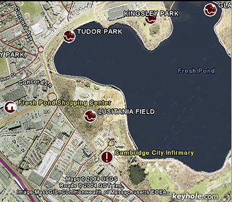
SmartView is Yahoo's "local search" tool which shows hotels, restaurants, etc. in the geographic area being searched. For now, Keyhole has points of interest overlaid on its maps, like the one at left of Fresh Pond, in Cambridge, where I like to go running. � "Entertainment aside, look for Google to rake in even more money as operators of hotels, motels, restaurants, and other travel industry operations pay to have their places included in the search." I have to say Mr. Coates is the only journalist I've read who suggested that method of bringing in revenue. A Final Note Completely unrelated to the acquisition, but related to searching, a new book suggests that today's searches are more about business and shopping than about adult entertainment. In Web Search: Public Searching of the Web Amanda Spink from the University of Pittsburgh and Bernard J. Jansen from Penn State report that back in 1997 adult searches accounted for about 20 percent of all searches, today its more like 5%. The book also notes that people don't want to work too hard at searching and typically use just two words for a search.

In 2001, ERM petitioned for summary judgment on the case, and it was granted. Basically, the court ruled that the way ERM software breaks up the image to do the compression (in lines) is different from LizardTech's (described as tiles). Thus, ERM "won." In 2002, LizardTech appealed the summary judgment, and a judge last March overturned it, stating that basically, a line and a tile are the same thing, and thus, ERM does infringe on the patent. That sent the case back to District Court. In March 2004, ERM again petitioned for summary judgment. The issue had to do with "wavelet coefficients in overlapping areas." Again, ERM stated its method was different than that held in the LizardTech patent. The patent was ruled invalid after a Special Master was appointed and a Markman hearing (which defines terms in a patent claim) held. Now, in 2004, LizardTech is appealing this second summary judgment. LizardTech notes in its press release that "this case has no relation to the emerging JPEG 2000 format." LizardTech has a FAQ online. ERM feels the case does indeed relate to JPEG 2000. Its release, titled "Lizardtech [sic] patent litigation threatens ISO JPEG2000 standard" outlines the logic. Says the release, "If Lizardtech [sic] were to win their appeal and overturn the ruling that Claim 21 of the '835 patent is invalid, then they may require that users of JPEG2000 - or indeed any wavelet based imagery format - pay a license fee to Lizardtech [sic] to use the '835 patent." The release goes on to encourage filing of "friend of the court brief" in support of ERM's position. More information on doing so can be requested via [email protected]. For those who are interested, LizardTech regularly uses "JPEG 2000" in its literature; ERM uses JPEG2000 and JPEG 2000. I'll stick with ISO spelling: JPEG 2000.
GISConnect V2 In order to use GISConnect V1, the user had to have a copy of AutoCAD and a copy of (or access to) a license of ArcGIS. GISConnect V2's "Standard" package supports that situation. A "Professional" package includes the ArcGIS license (ArcView level) via ArcEngine embedded within, meaning an AutoCAD user need not "bother" the GIS department to use one of its licenses. Further, the AutoCAD user need not buy a full box of ArcView that may not be used for anything else, saving several hundred dollars. One final package, the "Enterprise" edition supports connections to ArcSDE and supports ArcInfo functionality. Recall that ArcGIS offerings come in three flavors, with more editing functionality as one progresses up the list from ArcView, through ArcEditor, to ArcInfo. GISConnect V2 continues to support points, lines, and polygons supported by ESRI data files (shape files, personal geodatabases, and ArcSDE data). The new version adds support for mdata, measures used in dynamic segmentation. An updated interface, one that seems to me more AutoCAD-like, includes dockable data forms which make the interface more ordered. The biggest difference for hard core users will be the performance gains. The developers have done a lot of work behind the scenes to speed up query and drawing rates. The list of enhancements, most specifically requested by users, include support for labeling, the use of AutoCAD blocks for symbols that respect rotation information from the database, and the option to use AutoCAD's "real" polygon entities. The latter allows AutoCAD to make sense of complex polygons (with say, islands) but significantly increases the size of the DWG file. (There's no such thing as a free lunch!) New query tools allow users to query data into AutoCAD by a window or via a database query. The updated forms for displaying attribute information behave more like spreadsheets and include the option of sorting by column. Support for aliases allows data to be brought across from the ESRI side onto uniquely named layers. Spatial "bookmarks" can be saved and ESRI projection information is accessible. The number one request from users of V1 was support for versioning. While GISConnect V2 users can access existing ArcSDE versions and create their own, there are no conflict resolution tools.
Letters � Susan L. Zwillinger of Thinformation, Inc. / W.E.C. Engineers, Inc. shared some thoughts on productivity and GIS. "As a dedicated reader (and promoter) of your newsletter, I have to begin by saying 'Thank you!' I really appreciate the insight that you provide to the GIS world . . . or should I now say 'geospatial?' :) "In response to your review of Measuring Up, your readers might enjoy a recent Baseline article by Larry Dignan, The 500 Companies That Manage Information Best (You may have to search for the 'Next' hyperlink to get to subsequent pages, but it's there.) "The article discusses the research conducted by Baseline called the 'Baseline 500.' What is interesting is the formula used to rank the 500 companies: Information Productivity = Information Value-Added divided by Transaction Costs. Perhaps this approach could be used as a measure of GIS productivity?" She goes on to suggest: "A GIS ROI should reflect our information productivity. "As the GIS industry matures, I think that the software companies face some of the same problems that Microsoft has with its Office products. Check out this recent article by David Coursey in eWeek: Microsoft's Software Assurance Mistake "

Points of Interest Mobile Search a Step to LBS? After Yahoo! Offered mobile search tools recently, Google jumped into the fray with a similar offering. Google's offering is SMS-based (key in a code, send it, get response) whereas Yahoo's involves shortcuts directly to information. These efforts, says IDC analyst Dave Linsalata, suggest that "Yahoo and Google are taking an incremental step toward a time in the future when wireless users have access to location-awareness technologies." MapInfo Results. MapInfo reported net income of $5.1 million, or 28 cents a share, for the fiscal year ended Sept. 30, on revenue of $124.7 million. That's a record. The company also reported profits of $1.8 million, or 9 cents a share, up from $1.1 million, or 7 cents a share, a year ago making the last quarter the sixth consecutive with year-over-year improvements in operating margins and income. Next year the company expects revenue up 20 percent to 24 percent, to $149 million to $154 million yielding profits of 42 to 46 cents. Intergraph Results. Intergraph had a good quarter, too, with revenue for the quarter at $134.7 million, compared to $133.6 million reported in the third quarter of 2003. For the nine months ended September 30, 2004, revenue was $404.9 million, an increase of 6.1% from $381.5 million reported in the same period of 2003. Intergraph Mapping and Geospatial Solutions (IMGS) revenue for the quarter was $49.6 million, a decrease of 10.0% from the third quarter of the prior year and a sequential decrease of 3.8% from the second quarter of 2004. Those decreases, said the company, are the result of contracts ending. But, the really interesting thing for me is the description of the company in a press release noting a change in the time of the conference call. Intergraph Corporation is now a "leading global provider of Spatial Information Management software." And, that's the whole company, not just IMGS. Spatial Information Management (SIM) is a term I associate with David Sonnen and IDC, but which is used by Microsoft and some global organizations among others. In the press release announcing results of the previous quarter Intergraph was "a leading global provider of software and services for the management and visual representation of complex information." NAVTEQ Results. NAVTEQ Corporation reported record revenue for the third quarter ended September 26, 2004. Revenue increased 37% over the third quarter of 2003 to $97.8 million. Operating income grew 13% over the prior year to $22.1 million. Net income was $13.6 million, compared to $18.7 million in the prior year's quarter. Recall that this was the company's first quarter in its transition from a private to a public company. Highpoints productwise in the quarter included "the debut of our first-ever dynamic content offering with the introduction of NAVTEQ Traffic in 20 U.S. cities" and "the first steps with our joint venture partner toward the broad commercialization of a navigable map of China." Find Health Care Provider. Over in Switzerland you can SMS the type of health care you need and receive back, based on your location, the nearest such provider. Unfortunately, "However, no guarantee can be given, either for the accuracy or completeness of the information provided or for the correct operation of the service." The cost? About 75 cents. That sounds like a better investment than the recently announced U.S. offering for weather at that price! New Domains Possible. Last week the Internet Corporation for Assigned Names and Numbers (ICAAN) gave preliminary approval for two new top level domains: ".post" and ".travel." They could "go live" as early as next year. It's interesting to me that both are geographic. While other domains are up for consideration, these two got the early ok because of "the level of technical and commercial details" provided by sponsors. The Universal Postal Union in Bern, Switzerland sponsored ".post" and envisions its use for national postal services, local post offices, business partners, and stamp collectors. Private companies could use it, too. (www.fedex.post?) There are also suggestions such a domain would help like post offices around the world, and simplify delivery. The Travel Partnership Corp., a trade group, sponsored ".travel" for travel agents, airlines, bed and breakfast operators, tourism bureaus, and others in the travel industry. (www.marriot.travel?) Move Over Geocaching. That's right, its time for "geostashing." Teams hide and seek stashes of art supplies. When one is found, the group must create art at the location of the stash. So far, it's an urban experience, but who knows? Some details of early stashes are available on this blog. Gotcha! A 14-year old student in Tennessee was riding the school bus home the other day. He had his cell phone. He started making prank 911 calls reporting robberies, beatings, and other emergencies. But, his GPS-enabled phone gave him away. So did the sounds of children in the background. Authorities figured from the path the caller was on a school bus and with help from the school transportation department identified the bus and charged the youngster. I guess kids don't know that much about technology after all!
Kudos and Conundrums Kudos (concepts we applaud) A Child is Missing. Did you know there's a nonprofit group in Florida by this name that provides a free service to law enforcement that places phone calls to those in the area of a child/elder or disabled person reported as missing? Of particular benefit: there are no jurisdictional boundaries for the announcements. I ran across the organization after reading that a boy in Oklahoma was found safely in short order the very first time the system was used by local law enforcement. Conundrums (concepts we question/give us pause)
Health Risk Maps. BRFSS Maps is an Internet-based Behavioral Risk Factor Surveillance System (BRFSS) mapping application that allows users to map BRFSS data interactively for state and metropolitan/micropolitan statistical areas (MMSAs). Beginning with 2002 BRFSS data, visitors to the BRFSS website can create, save, and print state- and MMSA-level maps for health-related risk factors. The maps are courtesy of the Center for Disease Control, and while the FAQ references ColorBrewer, for selecting the colors, I found many of the maps difficult to decipher.
Please note: Material used herein is often supplied by external sources and used as is. � Announcements Dr. Bradford W. Parkinson, a resident of San Luis Obispo, Calif., an Edward C. Wells professor of aeronautics and astronautics (emeritus) at Stanford University, California, will be honored by the American Society of Mechanical Engineers. He is being recognized for outstanding leadership in the development of the NAVSTAR Global Positioning System (GPS), which is used for national defense, air traffic control, search and rescue, public transportation, and other applications. He will receive the Society's ASME Medal. (An actual mechanical engineer sent this in. Thanks!) GlobeXplorer added to its archive EarthSat's NaturalVue 2000 collection of 15-meter satellite orthophotos covering the entire globe. Avenza Systems Inc., producer of MAPublisher cartographic software, has begun a quarterly newsletter. Researchers, funded by Autodesk, report that the average AutoCAD 2002 user can realize almost 14 hours every work week in added productivity by switching to AutoCAD 2005. Researchers started with experienced AutoCAD 2002 users, and then observed them perform a series of standard tasks in AutoCAD 2005 that simulate the day-to-day production drafting environment. They compared their times to complete those tasks with the typical time it took in the older version of AutoCAD, as reported in a survey of users. For each individual task, the typical user experienced a productivity improvement of 30 to 60 percent -- all with a modest one-day investment in training. Hitachi Software has modified its HouseDiff change detection solution to use Pictometry imagery, and Pictometry has integrated the resulting change files into its Change Analysis software. Additionally, Pictometry will be able to market the HouseDiff solution to its customers. ISO has approved an International Standard developed by the Open Geospatial Consortium (OGC) with input from the ISO technical committee responsible for the ISO geographic information: ISO/TC211 Geographic Information/Geomatics. The OpenGIS Web Map Service (WMS) Interface Specification was approved by a ballot of the national bodies that are members of ISO. Intergraph Mapping and Geospatial Solutions honored six organizations for exemplary geospatial technology implementations at its second consecutive Canadian Intergraph GeoSpatial Users Community (IGUC) Conference. CSI Wireless Inc. had profit of $1.1-million in its latest quarter, reversing a loss last year. � Contracts and Sales Redo: The Swedish Maritime Administration (SMA) in Norrk�ping, Sweden has decided to migrate its Sysdeco chart database to Windows. DTE Energy Company (DTE) has selected ESRI software and support services for an open, standards-based enterprise geographic information system (GIS). Specialized data company MacDonald, Dettwiler and Associates Ltd. has signed satellite information agreements worth about $5.6 million with the United States and Norway. RADARSAT International announced that Norway (through the Norwegian Space Centre) has pre-purchased $2.8 million US worth of RADARSAT-1 data and products for the 2004 - 2006 period. This is an extension of a RADARSAT-2 agreement worth $10 million US which was signed in January of 2003. NAVTEQ has been selected to supply its products to both the Eurely and iNavSat Consortia which are bidding to become the Galileo concessionaire. The Consortia delivered their offers to the Galileo Joint Undertaking (GJU) on September 1, 2004 and the successful bidder will be given the task of deploying the Galileo satellite constellation and operating all subsequent services. � Products DeLorme now offers an ultra-compact, Bluetooth-enabled GPS receiver with data logging memory on board. The new Earthmate Blue Logger GPS offers a wide range of data logging and wireless data transfer for engineering, transportation, and field force professionals equipped with Bluetooth-enabled PDAs or laptop computers. NearSpace, a provider of location-based services for hospitals, events, hotels, convention centers, and universities, announced that it will deliver NearSpace to J2ME-enabled cell phones, expanding the company's reach to 250 million Java-enabled mobile devices. � Events Directions Magazine announced the agenda and a "call for papers" for the 2005 Location Technology & Business Intelligence Conference. The event will be held May 2-4, 2005 in Philadelphia at the Wyndham Hotel at Franklin Plaza on 17th and Race Streets. GeoVantage, Inc. will hold an open house on GIS Day - Wednesday, November 17, 2004, at the offices of General Aviation Services at the Beverly Municipal Airport, Beverly, MA. The event will showcase the vital role aerial photography plays in geographic information system (GIS) programs. In addition, attendees will have the opportunity to view GeoVantage's digital camera sensor system up close - actually installed on an aircraft in the airport hanger. � Training The new instructor-led course from ESRI, Cartography with ArcGIS, is designed for those who want to produce high-quality map products using ArcGIS Desktop. The three-day course teaches both the principles of good map design and how to apply them while using the cartographic tools in ArcGIS Desktop. � Hires @Last Software, Inc. (the folks behind SketchUp) informed its users that Mark Sawyer, formerly of Autodesk and Graphisoft, will be their new CEO. Rich Coons is coming into the team as VP of Sales and Marketing. He was with Access Graphics - I don't really know much about that company, but once at a show they gave me a cool purple polo shirt.
Advertise With Us
Contact GIS Monitor is published by: GITC America, Inc.
Subscribe/Unsubscribe |