Letters, Points of Interest, Kudos and Conundrums, Week in Review (Announcements, Contracts, Products, Events, Training, People) Back Issues, Advertise, Contact, Subscribe/Unsubscribe If, for some reason you cannot read this document, visit: http://www.gismonitor.com/news/newsletter/archive/012705.php
Another Endorsement for GISCI
[1] "OGIC [Oregon Geographic Information Council] adopted the GISCI certification as a means of recognizing the professional credentials of GIS practitioners in Oregon, but also as part an ongoing process of defining the boundaries between the GIS, surveying, and photogrammetry professions." [2] "Our next step will be to fully incorporate the GISP as an important component of GIS-related position descriptions in state and local government within Oregon." At least right now, there is no requirement that state or other government employees hold a GISP. But, the state does have a plan that "requires any agency or organization in Oregon that share geospatial data with other organizations or the public to have a certified individual who is responsible for sharing that data." Being a GISP may, one day, be part or all of defining that "certified individual." North Carolina, the first state to endorse the program, prompted GISCI to put out a PR back in December. North Carolina's endorsement doesn't seem to be tied to any particular requirements and was noted as being "unsolicited." The note above suggests that now GISCI is actively going to solicit endorsements. These first endorsements are worth watching; they may foretell how other states will use GISCI certification. I suggest that readers who feel strongly about the certification, one way or the other, be sure their state GIS leaders know of their feelings. One final certification note: While I do not post the names of recently certified individuals in GIS Monitor, local papers do. This is from The Detroit News: "Three members of Canton's Planning Services Division have recently become certified as Geographic Information Systems Professionals. [three people from Canton Township], have received certification from the GIS Certification Institute. Certification in the GIS field demonstrates initiative and provides a structured method of professional growth that can significantly enhance personal and career goals, township officials said."

Government Technology outlines TaxMatch, an online service (there's a map and non-map option), stand-alone program and soon data file, to answer that question. The hope is that down the road, more taxes will be collected by all the players. (The system is too new to yield comparison data yet.) The system was built on the state DOT's centerline road database, enhanced with address ranges. And, instead of using ZIP Codes, uses actual addresses to assign tax percentages. The system was developed in part to address standards defined in the federal Mobile Telecommunications Sourcing Act, passed by Congress in 2000. That act was supposed to simplify how cellular service is taxed at the state and local level. The system will also have bearing should states at some point be able to collect taxes from vendors outside the state.

The Numbers Game
Investors and analysts really get into those numbers. Every Autodesk press event I've attended included one or more editors asking about specific numbers of users, subscription holders, and the like. Autodesk is reticent to share them, especially for new products. And, if the numbers are shared, there always seems to be inherent suspicion from the press. I've been thinking about it from the user perspective. In many ways, it really doesn't matter how many people use the same software as you, except one person. The person sitting next to you!

Internet Buzz I personally found the statistic surprising because of all the buzz in recent years about "pay for placement" and the big "to do" when Google added sponsored links. These days many CAD and GIS portals have sponsored links. It made me wonder if website readers know the difference between press releases and original articles? This week Google and Yahoo! introduced tools to search TV shows. It's done by searching the closed captioning, not the actual dialog. The two index different networks and while Google provides still images and a few words, Yahoo! provides a one-minute clip. Google will also search local stations if a ZIP Code is provided. Yahoo! noted that some show owners are paying for the privilege of being indexed. Google would not say. Other services to this type of thing are already available. While this is a nice addition, these types of offerings irk me when I realize that solutions for searching geospatial data seem to be so far behind! That said, Google seems to know where the money is. And, we don't yet know how it intends to use recently acquired Keyhole.

Teens Endorse GIS Course; DOL Gives out More GIS Training Money At an event on January 10, Assistant Secretary, Employment & Training Administration Emily Stover DeRocco gave the fifth DOL grant. The Institute for GIS Studies Geospatial Business Hub Project will implement training at Central Piedmont Community College in Charlotte, North Carolina, and at a second site in Nashville, Tennessee. Said DeRocco, "Work done through this grant will train 425 individuals -- 100 associate degree students and 325 persons in continuing education. Curriculum for 23 courses and 3 courses for certificates will be developed." She noted that internships in Nashville and Charlotte will enhance the program and called out the contribution of Smart Data Strategies, the only GIS company involved in the regional effort. Other partners include Bank of America, Duke Energy, and local colleges and agencies. The Institute for GIS Studies Geospatial Business Hub Project received $2 million. The details of the other recipients, their partners, and how they plan to spend their money is detailed in a series of PDFs. It's pretty interesting reading. The projects run from developing "kids' contests" and teacher tools, to community college training, to enhancing the industry's public image.

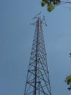
Can You Hear Me Now? Those who back the town include the National League of Cities and the California cities of Los Angeles and San Francisco. They fear that allowing damages could cause hardship to smaller, and some larger cities, and effectively force cooperation with among others, cell phone companies looking to build towers. The cell phone companies feel that the goal of a nationwide cell network could be easily prevented should towns and cities use zoning or other means to prevent cell tower construction. In the last 10 years 140,000 cell towers have been built in the U.S. The cell industry has two key pieces of legislation on its side. A 2004 decision in U.S. 9th Circuit Court of Appeals ruled that people are free to sue for damages if the government violates their rights. Combine that with the Telecommunications Act of 1996 which gives providers of wireless phone service a right to build their networks and things look a bit bleak.
Tsunami Update One More Tsunami Web Map Server. Cornell has put up a Web map server with data on Sri Lanka. This website includes data collected immediately after the event by scientists at the International Water Resources Institute, located in Colombo, Sri Lanka. The site is specifically geared to GIS pros and data downloads are available. The site includes damage photographs. Ordnance Survey Contributes. Ordnance Survey is helping to support the reconstruction efforts in Sri Lanka after the recent tsunami disaster. Britain's national mapping agency has shipped eight highly specialized GPS receivers to map out the worst hit areas and collect information useful for rebuilding and construction work. Intergraph Offers Support. Those involved in relief efforts can request software and support from Intergraph. GIS in Use. The Red Cross reports that GIS is, in fact, in use in relief efforts. An article in the Bangkok Post notes: "Aid agencies are also using geographic information system (GIS) software, utilizing computer-generated maps as an interface for integrating and accessing massive amounts of location-based information. GIS allows relief agency staff to get critical information about how humanitarian support efforts are progressing to ensure appropriate response agencies are acting in a coordinated and efficient manner. Once in the field, the co-ordination can continue as new data can be added and disseminated via wireless applications and Internet/Intranet connectivity." Mercy Corps in Action. A special fund has been designated to provide financial assistance to the Mercy Corps Geospatial Relief & Development Team. Mercy Corps is appealing to GIS and remote sensing communities, and those who appreciate what this technology can bring to the efforts in South Asia, to contribute. Mercy Corps currently has more than 60 staff deployed in the hardest hit areas of Southeast Asia engaged in the relief effort. A volunteer base of more than 50 GIS and remote sensing professionals in the Pacific Northwest has mobilized to apply geospatial technologies to expedite the flow of aid and accelerate recovery. Mercy Corps is requesting financial contributions to assist the ongoing emergency response of the Mercy Corps Geospatial Relief & Development Team and enable the establishment of a Non Governmental Organization (NGO) geospatial coordination team to reduce redundant efforts in emergency mapping, increase efficiency, detect change, transfer knowledge, and provide a geospatial data repository for all NGOs in collaboration with the United Nations Geospatial Initiative throughout all phases of recovery. In other Geospatial Relief & Development Team news, the group recently established a partnership agreement with the University of Washington Evans School of Public Affairs and its affiliate, Marc Lindenberg Center for Humanitarian Action, International Development & Global Citizenship to host the Mercy Corps-Seattle Remote Sensing/GIS Data Center. "This is a significant step forward in the process of introducing geospatial technology to NGO emergency relief and development programs" comments Glenn Brooks, who's been leading the efforts.
� A reader tested Garmin's software and reports: "I was glad to see MapSource and European Metroguide handle the route as expected."
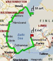
� A Finnish reader shared an analogous MSN map from that country from Vaasa, L�nsi, Finland to Rauma, L�nsi, Finland. The reader commented: "This is route is very difficult for Finns, we try to avoid [going] � to Sweden... But it seems that Microsoft is forcing us to build better relationship between these nations." The editor notes: This just in from Microsoft: A fix is coming in February. � After reading up on the legal issues on police tracking vehicles, a reader asked a very practical question, to which I don't have an answer. Readers? "I am perplexed by the article about GPS tracking. How do you hide a GPS device on a passenger car and still allow GPS satellite reception?"
Points of Interest Highest Ever Revenue for MapInfo. MapInfo Corp. reported its highest ever quarterly revenue this morning. Net income for the first fiscal quarter nearly doubled, while revenue climbed 21 percent. Net income for the three months ended Dec. 31 was $1.16 million, or 6 cents a diluted share. This includes 5 cents a share in charges related to the company's previously announced write-off of the remaining value of its investment in Alps Mapping Co., which were partially offset by benefits from changes in federal tax law. In the year-ago quarter the company showed net income of $637,000, or 4 cents a diluted share. Revenue was $34.7 million, the highest quarterly revenue ever, up from $28.6 million a year earlier. Full year revenue is expected between $149 million and $154 million. Motley Fool on MapInfo. I can't say I've ever read about a GIS company on the Motley Fool site, but there's a first time for everything. After chiding the company for noting a high percentage increase in net income and operating income from the last quarter (where it was about 0), David Meier goes on to praise what the company does and suggest it's a potentially good value investment. He also makes it clear the market was not fooled by the headlines of the growth; shares settled back nicely after the hype of the announcement, made early in the day. The Smoking Map. Walt Disney's idea of providing only limited smoking areas for its parks is spreading to other campuses. Humboldt State University in California has a new smoking policy that designates but 18 locations on campus where smoking is permitted. Six are near dorms and others were chosen to minimize the impact of second hand smoke on the population. The map's here and an article on the logic is here. I hope that unlike at Disney, which I wrote about a few years ago, the locations are clearly marked with signs. Ricoh Camera Really New? I had trouble with Ricoh's latest press release. (The release is not yet on the company website, so far as I can tell, but is available here.) The release says the GPS-enabled digital camera images, when "transferred to a PC� are automatically converted to shape files," when, in fact the GPS location points are actually converted to shape files. But, there's more to pick a fight with than that, in the release, says a blogger on Engadget. The camera is not the first of its kind (Kodak's predated it) and it's not a new camera according to his post. The camera is identical to one released a year ago, he offers, and that was confirmed by a call to a reseller, he states. NYC Data Sharing Hearing. New York City council's Committee on Technology in Government will hold a hearing entitled "Oversight: Releasing Geographic Information Systems Data -- Ensuring Security and Safety and Making Public Information Accessible" on Friday, January 28, 2005 at 10 A.M. in the City Hall Committee Room. The idea is to look at, among other things, "possible policies to adopt that would make the data available while protecting public safety; and whether or not current licensing of the service is too restrictive." If an NYC reader is attending, I'd love to share what went on with readers.
Kudos and Conundrums Kudos (concepts we applaud) HP Settles with Intergraph. Hewlett-Packard Co has agreed to pay $141 million to settle patent disputes with Intergraph. HP said the payment will reduce earnings for the first quarter of fiscal 2005 by about 3 cents per share. The two companies will immediately dismiss, withdraw, or terminate all pending lawsuits but with the right to reinstate them, according to one report. They also struck an agreement under which Hewlett-Packard is granted license to all Intergraph patents while Intergraph has license to all HP patents in fields covered by its current products. Two points on that last part: first the "patent sharing" sounds a bit like the deal between Autodesk and Microsoft noted recently and second, that seems to nullify the "gap closing" patent issue I described this fall, at least for Intergraph, and at least for right now. Montana Takes on Black Box. A hearing set for yesterday in Montana was to have a look at HB 322 which concerns "event data recorders" (EDR) or "black boxes" in cars. The Federal Highway Administration (FHWA) has mandated that all new cars must come equipped with EDRs by 2006. The "black box" stores information about how fast a car has been traveling, braking, turns, times of these, and a great deal more. The bill attempts to limit the invasion of privacy, "stating that a car (non-commercial vehicle) may not be sold in Montana with an EDR unless it has an owner-usable on/off switch, so the EDR may be disabled by the owner. It also says that any information stored on an EDR is the private property of the of the vehicle owner, may not be released to anyone else without the owner's written permission or a court order, and if the information is released without consent or court order, the owner may sue anyone involved for violation of privacy." The bill would take the wind out the FHWA's sails, no? Conundrums (concepts we question/give us pause) Miscoded. A new animated video parody of President Bush's inauguration had an error. It had Iowa coded as a blue state, when in fact, it should be red. Bush won the state by 10,000 votes, the first republican to do so since 1984. The video, called Second Term, was produced by JibJap Media. Instead of admitting it was a mistake, the company offered that the error may have been prompted by the fact that the state's vote count was so close. Yeah, right! GPS in Search of Problem. A review of the new Accura RL "poo-poos" the new iDrive joystick interface for such things as the radio and climate control. It also highlights two geospatial tools in the car. The car purchase includes a subscription to XM radio with "real-time" traffic information for 20 metro areas, including New York. XM signed with NAVTEQ for the traffic data, which it in turn gets from local police, transportation departments, and other sources. The reviewer could not get the traffic service to work, even after reading the instructions. Perhaps more interesting is this use of GPS: the climate system is "GPS-linked" which means the car knows the position of the sun relative to the car's driver and passenger, and uses that information to regulate cabin temperature. Is that really necessary? I recall driving in my best friend's Dad's Lincoln on long trips about 30 years ago. It simply maintained a constant temperature in the car. That was just great!
Please note: Material used herein is often supplied by external sources and used as is. � Announcements The Enterprise for Innovative Geospatial Solutions announced that member companies NVision Solutions, Inc., and Forest One, Inc., were selected as the winners in the Small Innovation and Small Industry categories, respectively, for the 2005 Salute to Business and Industry Awards program. This statewide recognition program is sponsored by the Mississippi Business Journal. Companies are judged by an independent panel of business experts on their contributions to the region and leadership in their segment. NVision won for REACT (Real-time Emergency Action Coordination Tool), which provides officials with digital maps, database reports, and automated environmental warnings during a crisis along with a list of available emergency resources. ForestOne specializes in GIS and remote sensing for forestry applications. GeoDecisions recently obtained the coveted ISO 9001:2000 certification for its operations nationwide. Bentley will deliver MicroStation functionality that publishes 3D models in Adobe PDF in the next Bentley SELECT update of MicroStation V8 2004 Edition, scheduled for release in mid-February. Users will need Adobe Reader v7 to see the models. � Contracts and Sales After a competitive selection process, the City of Auburn, Alabama has awarded Geographic Technologies Group, Inc., (GTG) a contract to plan, design, and create a total system-wide water, waste water, and storm water infrastructure model. ManTech International a provider of innovative technologies and solutions focused on mission-critical national security programs for the Department of Defense, Intelligence Community, the Department of State, the Department of Justice, Department of Homeland Security, and other federal government customers announced that the Intelligence Enterprise Joint Venture (IEJV) team has received a $209 million contract from the United States Army Intelligence and Security Command (INSCOM) to provide multi-disciplined intelligence and security support. Other team members include BAE Systems, EWA-IIT, and Northrop Grumman. Blister Entertainment Inc. (a division of KnowledgeWhere Corp.) has signed a licensing agreement with NAVTEQ to use NAVTEQ maps within Blister's location-based entertainment products. The agreement makes possible the use of NAVTEQ maps of North America in all of Blister's location-based entertainment products developed in the next three years. Blister is the company behind the location-based game, Swordfish. Gizmondo Europe Ltd., subsidiary of Jacksonville, Florida-based Tiger Telematics Inc. (once Floor D�cor!) selected MapInfo Envinsa location services platform "to provide core functionality for a range of location services for Gizmondo, the much anticipated and award-winning mobile, multi-entertainment device for 2005." Gizmondo is currently available in the UK and due in the U.S. and Europe in the spring. The company also announced that the San Francisco Bay Area Rapid Transit District (BART) will be providing its police officers with mobile access to critical information about emergency situations, wherever they may be, through the use of MapInfo location-based technology. � Products GfK MACON's digital maps of Puerto Rico have been updated. 124 5-digit postcode areas are now available. IONIC has released RedSpider LOBOS, an open solution for rapidly deploying location based services for mobile devices, Web applications, and enterprise processes. RedSpider LOBOS is Open Location Services compliant. Webraska Mobile Technologies' SmartZone Navigation solution is now available for all four major wireless operating platforms: Symbian Series 60, Symbian UIQ, Microsoft Windows Mobile for Smartphones, and Microsoft Windows Mobile for Pocket PC Phone Edition. The U.S. Army Engineer Research and Development Center's (ERDC) Topographic Engineering Center (TEC) released Corpscon Version 6.x, a software product that extends the usability of existing survey data and saves users the time and costs associated with more labor intensive data conversion or resampling. Though Corpscon is a Corps of Engineers product, it is available to the public at no cost and may be downloaded from the TEC website. Air-Trak, Inc., developer of the Cloudberry GPS tracking and communications system, announced that it is offering a Web service application programming interface (API) to allow customers and partners at no additional cost to easily integrate location, routing, or telemetry data with enterprise, office, or third-party software. Hitachi Software Engineering will launch the piXterra ASP service on February 1. The service will provide financial institutions with efficient real estate evaluation by using high-resolution images of properties collected by DigitalGlobe's QuickBird satellite. The images are updated biannually for major Japanese cities. The service is available for 20,000 yen ($200) per PC. � Events The 15th Annual Texas GIS Forum will be held April 25-29, 2005 at the J.J. Pickle Center in Austin. Monday and Tuesday will be devoted to workshops and meetings and as usual we will have two and one-half days of presentations on Wednesday through Friday noon. Presentations will be grouped by a particular theme or focus. Each presenter will have twenty minutes for the presentation and five minutes for questions. A moderator will facilitate the session and ensure that each speaker has an equal allotment of time. All presenters will receive free admission to the Forum. Details via mberbrick(at)grandecom.net Exor, a provider of highways management software, announced a series of UK seminars to address the individual needs of Authorities and Utilities in response to the Traffic Management Act (TMA). GIS for Transportation Symposium will be held April 3-6, 2005 at the Cornhusker Hotel in Lincoln, Nebraska. Oracle Corporation will host a one-day seminar on the use of Spatial Data for IT Management in Asset Intensive Industries. Graham Sticker Product Director of Exor, a leading provider of spatial and linear referencing services for network and asset management, will present at the event on March 3rd 2005 Oracle, Blyth Valley Park, Birmingham, UK. European Geosciences Union will be held at the General Assembly Vienna, Austria, 24-29 April 2005. As EGU 2005 will be the first international science conference after the December 2004 Asian tsunami disaster, a special Union Symposium will be held presenting the latest reports from scientists who have been working in the area before and after the event. More than 200 mobile information professionals from the largest automobile manufacturers, wireless carriers, mobile electronics vendors, homeland defense, and computer companies will meet February 24-25 for GPS-Wireless 2005 at the Marriott Hotel-San Francisco Airport. Those offering the conference maintain that other similar events cost two to three times and much and deliver less. The cost is $800. � Training � People GeoVantage appointed Les Strauss to its Board of Directors. He was Chief Financial Officer (CFO) and Secretary at PictureTel Corporation, a video-conferencing equipment company. EarthData announced the appointment of Joel Campbell as Senior Vice President of Corporate Sales. In this newly created position, Mr. Campbell will expand and lead the organization's worldwide sales teams, develop new vertical and geographic markets, and maintain strong relationships with EarthData's existing customer base. Mr. Campbell also will support the organization in acquisitions, legislative action, strategic planning, and industry affiliations. Campbell was most recently ESRI's Director of U.S. Sales and Manager of the Washington, D.C. regional office. Congrats, Joel! AERO-METRIC, INC., Sheboygan, Wisconsin, announced it has named Roger E. Crystal as contracts manager for federal programs. Crystal has more than 35 years of experience in the geospatial professional. He is a Past President of ASPRS and a current member of the MAPPS Board. Prior to joining AERO-METRIC, Roger worked for the USDA-Forest Service as the Director of Information Resource Management. In 1996, he joined Titan Corporation as the Director for GIS, Portland, Oregon. Intermap Technologies announced that Robert Eadie has been named director Northeastern United States.
Advertise With Us
Contact GIS Monitor is published by: GITC America, Inc.
Subscribe/Unsubscribe |