Letters, Points of Interest, Week in Review (Announcements, Contracts, Products, Events, Hires) Back Issues, Advertise, Contact, Subscribe/Unsubscribe If, for some reason you cannot read this document, visit: http://www.gismonitor.com/news/newsletter/archive/021904.php
Editor's Note Also, to keep GIS Monitor mailings to a reasonable size, my take on AutoCAD 2005, announced this week, is available on the GIS Monitor website. Adena

Mapping Sciences: New Standard, New Company, Short Life The Lawsuit The lawsuit, described in the press release as "ongoing" revolved around "misappropriation of trade secrets." That's a rather broad term which can mean, according to one law firm's website, "using the software of another party without proper authorization or providing it to third parties for modification without consent of the owner." It also can involve copyright, trademark, and other related issues. Mapping Science's core business was supporting the ISO standard JPEG2000 for mapping applications. I wrote about JPEG2000 at length last January. Mapping Science's core technology was not built by the company; it was licensed from Kakadu. A Frequently Asked Questions (FAQ) document posted on the Mapping Science website explains that "LizardTech was suing Mapping Science and six former LizardTech employees, who founded Mapping Science, for misappropriation of trade secrets and breach of their nondisclosure agreements with LizardTech." With the transfer of assets, the suit has been dismissed. Non-disclosure agreements (NDAs) are very common in journalism. Journalists are told many things that can't be shared until a certain date. Employees and consultants involved in technology (and other fields, too) are often asked to sign NDAs when they begin working for a company and often these last beyond the length of service, sometimes indefinitely. While not specifically mentioned, there's another feature of contracts that may be in play here as well: a non-compete. Such a clause prevents someone working in a field from working in the same field, after leaving the employer. Shutting Down and Passing on Intellectual Property Mapping Science cites not only the lawsuit, but also current market conditions and competition, as reasons the company will cease to operate. It's also worth noting that a two-year-old company like Mapping Science likely did not have the resources of a LizardTech, now owned by Celartem, to cover litigation costs. To my knowledge the marketplace for geospatial use of JPEG2000 included Mapping Science's GeoJP2 format based on GeoTiff tag style storage (that is, Mapping Science took the GeoTIFF geospatial tags and used them for map projection information, inside the normal JPEG2000 file format and JPEG2000 wavelet format), Luratech's ISO compliant solutions, and the "old fashioned" world files ESRI's made a de facto standard for image registration. MSI made its GeoJP2 format, and code, available via a royalty-free license. PCI Geomatics used MSI code to support GeoJP2 and ESRI and Leica signed on to include support for GeoJP2 in ArcGIS and ERDAS IMAGE. Both companies put a positive face on what was likely to have been a painful process, noting that not going to trial was a plus. Mapping Science president Walt Wiley is quoted in the press release saying that he had confidence LizardTech would take good care of his company's customers. By late last week a letter from LizardTech CEO Carlos Domingo appeared on the Mapping Science website, noting the changeover. LizardTech will in time incorporate GeoJP2 into its GeoExpress product designed for creating, viewing, and publishing geospatial imagery. LizardTech is also working on a development kit that will enable support for MrSID and JPEG 2000, within a single software development kit. Mapping Science had never released an SDK for JPEG2000, noting, in an FAQ, "Mapping Science believes that SDKs are not appropriate products for a technology that is as complex and feature rich as JPEG2000." LizardTech has been noting its new Technical Committee membership in the Open GIS Consortium (for which I consult), for the last several months, in nearly all of its marketing materials. One thing the company hopes to do within that body is develop an open, group-developed standard to store geospatial metadata in JPG2000. From a standards perspective, some could argue that Mapping Science's solution, the structure it put forward for GeoJP2, was not developed in an inclusive way. While it does indeed "work," it does not fall into the "open standard" category because MSI held the license to the specification (though it was freely distributed) and only one company was involved in developing that specification. One company that's ready to get into the fray is Earth Resource Mapping (ERM) which early this week confirmed its commitment to JPEG2000. The company announced the imminent release of its ECW JPEG2000 SDK that offers compression and decompression into both the ECW (Enhanced Compressed Wavelet, ERM's image format) and the JPEG2000 image format. The kit includes source code and two free licenses. A commercial license has a fee. ERM is following Mapping Science's lead, choosing not to implement a per megabyte charge for compression (which LizardTech maintains). And, until the end of March, ERM is offering 50% discounts, to Mapping Science clients, on ER Mapper 6.4 and the ECW JPEG2000 SDK. The future of JPEG2000 seems to be assured. All of the experts I've spoken to in recent months have identified it as the eventual standard. It's on par, they suggest, with ECW and MrSID, and has the bonus of being open. Some offer that there will be a time when many flavors are available (just like existed with TIFF) but that will in time settle down. Speculations While this is all quite complex, recall that LizardTech has a history of lawsuits. It's actually still involved in one with competitor Earth Resource Mapping. That suit has been going on for five years. Perhaps this is simply a litigious company? What did LizardTech get in the transaction? It seems that while several of the employees will be hired as short term consultants, there are no plans to hire any full-time staff. That might make one wonder about the long term commitment to the MSI products, or JPEG2000. Further, the GeoJP2 format and the code to implement it were already freely licensable, so there's no big intellectual property bonanza there. MSI's client list is valuable but likely not very long after just a few years in business. One interested party wrote a piece suggesting that LizardTech's actions are very Microsoft-like. Says Howard Butler of Nevada: "They [LizardTech] are following the lead of companies like Microsoft in that they are trying to own the standard. Microsoft has owned the standard operating system for years, have profited from it greatly and bullied anyone who tried to get into their space with lawsuits, threats, and extortion." He also draws an analogy to ESRI trying to own the standard for GIS data. Celartem, LizardTech's owner, is in an interesting position. The company has its own technology and several subsidiaries. Last year one of these subsidiaries purchased DiamondSoft, the company behind Font Reserve, a font management solution. Unfortunately, similar technology is now part of Mac OS X (Font Book), shrinking the size of the potential market. That may have had to do with the company revising its first half year fiscal net expectations (ending June 2004) downward, by just about 150% at the end of January. The company expects annual net revenue of an $11 million dollar loss on $31 million in sales.

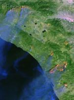
Resource21 Aims High, Falls Hard What went wrong? Perhaps, needless to say, not a lot of people involved have spoken publicly about the situation. Though I'd heard from imagery people in the know immediately after the rejection that Resource21 would not be in business long, I didn't see anything official about termination until just this week. I'm not sure it's related, but I also was surprised at how little media coverage both the decision to "not fix" the ailing Landsat 7 and the bid rejection received in the geospatial press. The Beginning Resource21, by all accounts I've heard, was launched in 1995 specifically to bid on the Landsat continuity contract expected a few years later. Backed by Boeing, a company adept at building satellites, the company was well seated to deliver on a contract which was basically a satellite manufacture and operations deal. Early promotion of the company, noting backing from BAE SYSTEMS, Farmland Industries, and the Institute for Technology Development, in addition to Boeing, touted the company as serving the agriculture market and looked forward to the Landsat continuity mission. The Landsat 7 imagery below right was from October 26, 2003 near San Bernardino and reveals several fires.
The company signed on to resell SPOT imagery and partnered with Pixxures for an online agricultural imagery service. I've noted in the past how few agriculture-related efforts in imagery seemed to pay off. Pixxures recently sold off its Canadian subsidiary and part of Emerge, once owned by ConAgra, a company tied into agriculture, is now owned by Applanix. The 2003 Commercial Space Transportation Forecasts reports that Resource21's proposed satellite, manufactured by Boeing, would go ahead no matter the outcome of the Landsat Continuity Mission decision. The satellite, with a 10-meter sensor was set to be in orbit by 2006. Boeing had pulled a license for the satellite in 1996, when the company was formed. Preparing for the Bid Back in March 2002 Resource21 and DigitalGlobe were given small awards to refine their respective plans for the final bid. DigitalGlobe eventually pulled out of the bidding process citing high risks. That decision could have been taken two ways by Resource21: "Oh good, we are the only bidder!" or "Hmm, I wonder why they are dropping out?" DigitalGlobe has a business savvy reputation that might have been taken as a sign to look carefully at the bid. On the other hand, a smaller outfit like Resource21 might have thought that a quick, young company could outdo an older, larger rival, like DigitalGlobe. The End In the end NASA felt the cost of Resource21's bid was too high and according to a report in Space News, "amounted to the government shouldering the entire cost of building and operating a privately owned satellite." Just as a side note, recall that on the military side of things, NGA hands out $500 million contracts to companies such as Space Imaging and DigitalGlobe with some regularity. Resource21 felt it was offering a good deal. Its satellite would cost $711 million to build, launch, and run for five years. The company felt it was offering the government a discount of up to $145 million. (I'm not sure how they got that number.) Landsat 7, in comparison, cost about $700 million to get into orbit and $20 million per year to operate. Resource21 hoped to sell $1.37 billion in commercial sales during the first five years of operation. NASA didn't feel the company was investing enough in the effort, but was instead reducing its risk to near zero by receiving regular payments from the government. NASA didn't find this a fair partnership. Speculations When I look over this story it sounds like one of those "putting all your eggs in one basket" situations. Moreover, it can be argued it wasn't the right basket. While Space Imaging, DigitalGlobe, and ORBIMAGE have taken big risks putting commercial satellites in orbit, I for one always understood they had a "pretty sure thing" in support from the U.S. defense industry. That support has only increased since the White House issued statements about support of commercial imagery and the U.S. has gotten increasingly involved in world affairs since 9/11. On the other hand, despite scientific interest in worldwide and regional environmental issues, there's been perhaps too little "buzz" at the government level about satellite technology to serve related disciplines.

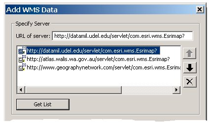
The download and install are straightforward. The extensions come with a 16-page User Guide that details how to use the added toolbar. (Images are from the User Guide, used with ESRI's permission.) There is one button each for WMS and WFS and two for GML, one to read it in and another to write it out. ESRI presents the toolbar and succinct guide to users who are already familiar with the idea behind the specifications and have specific servers they'd like to access. It's important to realize that the OGC specifications are regularly updated. ESRI's tools support WMS 1.0.0, 1.1.0, and 1.1.1, WFS 1.0.0, and GML 2.1.2. The currently available specifications are WMS 1.1.1, WFS 1.0, and GML 3.0. WMS The WMS button opens a dialog box where the URLs of WMS can be entered. ESRI does not provide a list of suggested URLs in the extension, but does point to one WMS from the Geography Network and another hosted by NASA in the User Guide. A list of some twenty-five WMSs is available in an appendix of the User Guide. Once a server has been provided, the "Get List" button will query it for available layers. The user can then check off the layers of interest that are returned and add them to an ArcMap document. We added data from the Delaware DataMil with no trouble. It was correctly projected and located on a StreetMap (that's a U.S. data set from ESRI) layer. We found the DataMil URL by searching the Geography Network for registered WMSs. There were 49 when we looked. Each WMS added is saved to a list available in future sessions.
WMS features are typically used just as background since they are what ESRI calls "images services," that is, just a bitmap is returned. Still, the features can be identified in ArcMap if the server supports this functionality. The "regular" ArcMap identify tool can perform identifies on WMS features, and returns attributes for any features that intersect the point "clicked." Within the WMS client tools there are no options to select which bitmap format was used (PNG, GIF, or JPEG), nor support for transparency, nor the option to use a Styled Layer Descriptor file (SLD) to drive symbology of the WMS. I saw no place to query for legend information. An ESRI representative explained that "currently the first image format returned in the Capabilities response is automatically requested by the Interoperability Add-on. In the next release we will be looking to provide an option that allows the user to specify what image format they'd like to retrieve. Regarding legends, she added, "currently there is no mechanism to retrieve a legend. Our next release will look to support this, as well as dynamic rendering (via SLD)." Transparency could be adjusted using the tools in ArcMap. The documentation explains that since the data is coming via the Internet, there are times when servers go down, or traffic is slow, something that may cause frustration to users new to Web services. WFS The WFS button works essentially the same way. We weren't able to look at WFS in part because of the difficulty in finding public servers that support the specification. I suggested we access some listed on IONIC Software's Ask the Spider listing of OGC servers. To my knowledge, it's the largest list available, worldwide. (I'll share again my frustration that there's no central catalog for these services. It's a key part of educating the world on what interoperability is about.) The few WFSs we did find, all hosted by IONIC Software, yielded errors. The FAQ suggests that error might be due to the file including unsupported elements. We were unable, by looking at the IONIC website, to determine the type of GML delivered. Posters to ESRI's forum on the add-ons report that a service from ESRI's Canadian Geography Network (http://dev.geographynetwork.ca/ogcwfs/servlet/com.esri.ogc.wfs.WFSServlet?) does work. There is a curious statement on page 1 of the User Guide which I suspected was a typo, but which ESRI states is not: "The OGC Interoperability Add-on enables you to add �feature services from ESRI Web Feature Services�" An ESRI representative reports, "ESRI WFS is based on the profile for GML that ESRI is currently using. The Add-on will also support any WFS that uses the same profile of GML as ESRI's WFS. ESRI has taken the initiative by defining a GML profile and implementing this profile in the OGC Interoperability Add-on for ArcGIS and other software extensions. ESRI is working closely with other OGC members to define an OGC profile that will be standardized. This will be called the Level 0 profile. ESRI's goal is to work with OGC members and help create an OGC specification rather than an ESRI one, therefore ESRI has chosen to not widely publicized our GML profile." More information on ESRI's profile work is available in this ArcUser article. GML The two GML buttons have two fields in their respective dialog boxes: one for the GML file and one for its schema (.xsd) file. The former holds all the data (geographic and attribute) and the latter how the data is structured. Data imported from GML is converted to ArcMap features of four types: point, polyline, simple polygon, and complex polygon (a polygon with holes). Once converted to shape files or another type, the data can be acted upon just like any vector data - it can be edited, deleted, resymbolized, etc. While not noted in the User Guide, I suspect the GML tools are also built on the profile noted above. Bottom Line This is the first appearance of OGC client support in ESRI's desktop products and it is to be applauded. Posts to the forums from ESRI staff note that feedback from this release will be used to craft updated versions for ArcGIS 9.0. (The current add-ons are not supported under the 9.0 beta now available to some users.) Several other posts request that ESRI put client support for OGC specs into the ArcIMS Connectors. Those add-ons allow ArcIMS to serve data following the OGC specs. Adding client support to the connectors would mean that WMS and WFS services hosted outside an ArcIMS implementation could be harnessed, then republished via ArcIMS. That's referred to as a "cascading map service" and has some interesting possibilities.
I wrote: "There was one other impressive labeling feat: masking linework so that the value of, say contours, can be clearly seen." Mr. Herberich responds: "Well, we think that this is not that impressive at all, and it was one of the top ten annoyances of ArcMap. Look at something like Surfer from Golden Software. The real problem, and this is the ESRI way in all that they do, is that there was a model chosen for labeling (labels and features draw entirely separately) that made contour labeling like you describe 'hard to do.' So ESRI blew it off, until now. Of course, back in the day, ArcPlot would try to do it with the BLANK option of the ARCTEXT command, but only sorcerers had any luck." � Geert Lammerts van Bueren of ARCADIS in The Netherlands shared his observation on location-based services in that country. "I'm reading your newsletters now for several years, but this is the first time I see reason to react. "I was attracted by your column on MapPoint Web Services 3.5. "You state in your column: 'MapPoint Web service is maturing. I for one think the big bump in usage will come if, in fact, Microsoft delivers a killer LBS platform later this year. That said, I haven't seen a platform make LBS explode, since there are so many other issues yet to be solved, such as how to locate mobile devices!' "However, in The Netherlands I see several people around me buying a GPS-enable[d] PDA. They are even for sale at Aldi at � 499,--. These devices come together with a digital map and location databases with Restaurants, Hospitals, Gas stations and so on. "I realize that these devices have yet no connection to the Internet, but I assume that to be cheaper than adding GPS to a telephone. One's that's done, the step for connecting to a MapPoint server is very tiny. "I'm very curious how these developments are in the States." My reply: GPS receivers are inexpensive here, too, running about $500 with data similar to that you mention at discount stores. The big deal here is that cell phones, by law, by 2005 must be locatable. So, if you want a cell phone, you must pay the premium. There are still carriers looking at non-GPS solutions, actually, in part due to cost. The other thing I think vendors and users are realizing here is the "real-time" requirement of LBS. They are realizing the value of real-time traffic information, or real-time weather which is not available on the devices you describe. I'm still pretty skeptical about LBS myself, but have to admit Microsoft has the power to bring things to business and consumers that say, Autodesk does not. � Larry C. Stout, P.E., GIS Manager in Hamilton County Indiana added one final note to the recent imagery discussion. "Nobody mentioned that straight bridges become curved in the ortho rectification process. It looks really strange to see a straight road on either side of a curved bridge. Kind of like a horizontal speed bump. When you manually edit the orthophoto to take the curve out of the bridge, it creates this sliver containing no data. When we get an orthophoto with a curved bridge (that is not really a curved bridge), we ask our vendor to straighten it. It doesn't happen often; most of them have been corrected before we get them. "Buildings don't curve, they just lean, which is what you are used to seeing from an airplane anyway. A leaning building doesn't pose as serious a threat to the orthophoto's credibility as a curved bridge."
Points of Interest Intel Wins on Appeal. Ready for this? Recall that Intergraph sued Intel for patent infringement and won $150 million. Part of the deal was that if Intel should appeal, and lose, Intel would fork over another $100 million. The $150 million was to stay put. Well, Intel did appeal. And, the court threw out the case! It also sent the case back to district court to look again at if infringement did occur. That means no extra $100 million payment. But the court isn't so sure the $150 million that Intel paid should stay in Intergraph's bank. Certainly Intel hopes the funds will be home soon. This is one of the weirdest lawsuits I've ever tried to follow! Intergraph stock dropped about 8% on the news. Intel stock was up 1.5%. MapInfo Annual Investor Meeting. Nothing really new here: President and CEO Mark Cattini basically outlined how the company would not let itself get into the same hole as a few years ago by focusing too heavily on one market. He noted that the company would now be paying particular attention to specialized solutions, which he offered, bring in more money. Unlike Autodesk and ESRI who attempt to diversify with the help of partners, MapInfo has been rather quiet about the role of that part of its sales and development force. Also of note, Cattini received a $50,000 and a $388,000 bonus last year, irking some shareholders. The company argues he deserves it based on the recent turnaround. OS Work Goes to India, Via Denmark. In what some consider the largest mapping deal in the world, ever, Cowi of Denmark will provide Ordnance Survey with flying and photogrammetric services. Cowi will do the flying during the five-year project, but the production work will be done by 51%-Cowi owned Kampsax's Indian subsidiary, Kampsax India. The Indian company's 200 mapping specialists have become a key part of the Cowi operation causing the shutdown of most of the other company sites doing such work in places like Poland. What to Do With Homeland Security Grant? Ottawa County Ohio has received several installments of money from the federal government aimed at homeland security. The first $118,000 went to "equipment" and the next pot of money, says the head of the county emergency management agency should be spent on things that will benefit everyone in the county. According to an article in the New Herald, the county Homeland Security Advisory Team members expect funds to be used for a "Geological Information System" that would support first responders. The first four grants could only be used on buying equipment, while later ones can be used for planning and exercises. That shiny new fire truck is worthless if you can't maneuver it to the site of a disaster because your maps are out of date.... GPS OK'd for Peterson Trial. "The generic methodology is generally accepted and fundamentally valid," said the judge in his ruling. The judge also required the prosecution to tell the defense the location of the device on the vehicle, something thus far known only to the police. Said Peterson's lawyer, "If the FAA will not approve GPS for the landing of an aircraft, how can a court of law approve its forensic use in a capital case?" I'm not sure I see the connection. Thanks to Woody who sent me a link, just as it was posted on the Web.
� Announcements Intergraph Mapping and Geospatial Solutions, in collaboration with the Association of Geographic Information Laboratories for Europe (AGILE), announced the second Intergraph research grant opportunity for AGILE members. One hundred United States 4-H clubs will receive grants containing GIS software, data, books, and other support materials as part of a new initiative from ESRI created in cooperation with National 4-H Headquarters; Cooperative State Research, Education, and Extension Service (CSREES); and the U.S. Department of Agriculture (USDA). Thousand Oaks-based SciAutonics LLC and Israeli company Elbit Systems Ltd. have formed a collaboration to enter the DARPA Grand Challenge. ESRI is on board as a sponsor as is Airborne- 1, an aerial LiDAR mapping company based in El Segundo, CA. The U.S. Geological Survey (USGS) recently signed separate Memoranda of Understanding (MOU) with the National States Geographic Information Council (NSGIC) and the National Association of Counties (NACo) to further enhance development of The National Map and to improve collaboration among all levels of government. I wish I could get excited, but MOUs are the organizational equivalent of "strategic partnerships" in business. When I see the fruits of the partnership, I'll get excited. Trimble will buy privately-held TracerNet Corporation of Chantilly, Virginia, a provider of wireless fleet management solutions, in an all cash transaction. Certified PCI Geomatics training professionals can now teach eCognition from Definiens Imaging. Geographical & Environmental Data Services, Inc. and Resource Strategies, Inc. are now resellers of GeoExpress with MrSid. � Contracts and Sales The Municipality of Madrid, Spain, has chosen GeoMedia technology as the geospatial infrastructure management solution for its irrigation system. Intergraph Mapping and Geospatial Solutions announced Hydro Ottawa Limited has signed a contract for additional Intergraph Geospatial Resource Management (GRM) solutions. Ness Technologies, a global provider of information technology solutions and services, announced a three-year contract with the Czech Office for Surveying, Mapping, and Cadastre (CUZK). Under the terms of the contract, Ness CEE (Central and Eastern Europe) will provide development and maintenance services for ISKN - the Czech land register information system. Ness won the contract following a public tender. IONIC Enterprise and MCH have been awarded a contract by the National Geospatial-Intelligence Agency (NGA, formerly NIMA) to supply geospatially-enabled data on critical facilities and captive population nodes, including hospitals, ambulance services, schools, nursing homes, and other types of institutions. These data will become part of NGA's Homeland Security Infrastructure Program (HSIP) Database for use by Federal Agencies in their emergency planning process. � Products Maponics announced the release of its Nationwide ZIP Code Map CD. The CD-ROM contains maps of all 50 states, as well as the District of Columbia, in Adobe PDF format. ESRI announced that ArcWeb for Developers now includes Geographic Data Technology (GDT) North American street data. That means developers can creates in and between the U.S. and Canada. Service Pack 2 (SP2) for Manifold 5.50 has been published and is available for immediate download at no charge. SP2 delivers more than 200 new features, including many bug fixes. The company is also offering two extensions: Business Tools and Surface Tools. The main user forums for Manifold are Manifold-L are online. The next edition of Manifold System, Release 6.00, will soon enter beta testing and is expected to be released in late spring or early summer of 2004. Want to learn more? The company will be at GITA in Seattle. eSpatial, a spatial information management company, announced that its iSMART product suite is compatible with Oracle Database 10g. Apparently 10g is now available. � Events The Hawaii Geographic Information Coordinating Council (HIGICC) presents GIS Mapping in Asia and the Pacific (GISMAP) 2004 Conference: "Protecting and Strengthening Communities in the Pacific" June 7 - 9, 2004 to be held at Waikiki Beach Marriott Resort Honolulu, Hawaii 96815. � Hires Eric Waldman, was appointed Senior Director of Sales and Channel Development at GlobeXplorer and will head up GlobeXplorer's growth plans in the mapping/AEC market, the federal government and visualization/simulation sectors. BAE Systems has opened a new sales office in Tampa, Florida, to support expanding sales in the commercial and government mapping and geospatial intelligence markets in the Southeastern United States. This office is staffed by Travis Ritter, formerly of Intergraph - Z/I Imaging, and David Reed, formerly of USSOCOM. GCS Research LLC, a geospatial information technology company, announced the addition of Neil Lofgren to the company as Director of Engineering. Laser-Scan appointed Arash Karimi as Radius Topology Sales Manager. He comes from Ericsson Technology Licensing, where he was responsible for supply chain management and sales.
Advertise With Us
Contact GIS Monitor is published by: GITC America, Inc.
Subscribe/Unsubscribe |