
|
|
News Briefs, Back Issues, Advertise, Contact, Subscribe/Unsubscribe If, for some reason you cannot read this document, visit: http://www.gismonitor.com/news/newsletter/archive/092205.php
Editor's Introduction 
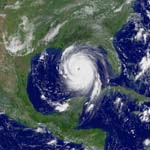 Hurricane Katrina: Geospatial Responses The geospatial community is mobilized to assist in recovery from the devastation inflicted by Hurricane Katrina. Following is a second batch of (slightly copyedited) excerpts from some of the descriptions I received from various companies as to what they are doing to help. (You can read the first batch here.) Tele Atlas "For years, Tele Atlas has worked closely with state and local officials across the United States to create the most up-to-date and comprehensive digital map database of the U.S. road network. More recently we've been honored to help them as they manage rescue and recovery efforts along the Gulf coast.
Intermap "Existing, or pre-hurricane, Intermap NEXTMap USA data has been delivered to USGS EROS and will be made available to qualified government agencies in support of disaster relief efforts. NEXTMap data includes 5 meter posting Digital Terrain Model and Digital Surface Model data with 1 meter vertical accuracy and 1.25 meter Orthorectified Radar Image data with 2 meter RMSE horizontal accuracy. Data was collected in 2004 and 2005. The data covers all of the disaster area and is provided with special license terms without fee for use during the remainder of 2005. The government agencies that qualify will include any federal agencies supporting relief efforts, state agencies within the three-state disaster area, and counties declared as Federal Disaster Areas. Data will be supplied through USGS EROS contact Ms. Brenda Jones, Disaster Response Coordinator, 47914 252nd St., Sioux Falls, SD 57198. Phone (605) 594-6503. Direct requests for data from organizations outside of this group to Intermap contact Mr. Ian Isaacs at 720-974-3287 or [email protected]." Autodesk "As soon as it was clear how bad Katrina was, Autodesk started assembling our best experts and got them ready to go to the Gulf Coast. We have civil engineers, former members of the Army Corps of Engineers, architects, emergency response experts, you name it. We knew these were the kind of experts who would be desperately needed in the aftermath of the storm, and we're fortunate to have them all in one place where we can easily deploy them. And they were eager to do it. Autodesk
AirPhotoUSA "AirPhotoUSA received post-Katrina one-foot resolution imagery from the National Oceanic and Atmospheric Administration (NOAA). The company processed it and released it as seamless, highly accurate orthophotography within 24 hours. The new imagery made a critical difference to response efforts including those being carried out by organizations such as Wal-Mart Corp. Using PhotoMapper, they were able to quickly and easily create the best routes for their trucks to safely deliver crucial supplies to relief sites. Expanded pre-hurricane coverage will be available in the near future and we will continue to release post hurricane updates as they become available. AirPhotoUSA's goal is to provide customers with a current and historical comparative view of the disaster area with an aerial imagery solution that is accessible, easy-to-use, and versatile to the widest array of application and personal need. AirPhotoUSA provides imagery, free of charge, to qualified emergency and first response teams, nonprofit relief organizations, broadcast news corporations, and others actively involved in the relief and recovery effort, as well as individuals affected by the disaster." 
Hurricane Katrina: The Role of GIS Volunteers Of the many public and private organizations assisting with the response to and recovery from Hurricane Katrina, none make the geospatial community prouder than the Urban and Regional Information Systems Association's GISCorps, which coordinates short-term, volunteer-based GIS services to underprivileged communities. Launched in October 2003, it operates entirely on a volunteer basis under URISA and is run, for now, by six "core committee" members. These six people, who are themselves GISCorps volunteers, are scattered across the United States and use a twiki site to work collaboratively, mostly at nights and on weekends. On Monday, I discussed the GISCorps' hurricane relief work with Talbot J. Brooks, director of the Center for Interdisciplinary Geospatial Information Technologies at Delta State University in Cleveland, Mississippi, and Shoreh Elhami, GISP, co-founder and chair of URISA's GISCorps. Elhami is also GIS Director for the Auditor of Delaware County, Ohio; an Adjunct Instructor in the City & Regional Planning Department of Ohio State University; and a member of URISA's board of directors. Together, Brooks and Elhami recruited, mobilized, deployed, and coordinated scores of GISCorps volunteers to assist in mapping the devastation along the Gulf Coast. 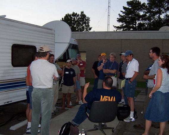 Volunteers preparing for shift change Brooks, who is also a volunteer firefighter in Bolivar County, Mississippi, was familiar with emergency operations and in regular communication with Kent W. Buckley, the director of the county's Emergency Management Agency. Brooks met with Buckley on the morning of Saturday, August 27 to share a crude map he had made showing Mississippi counties overlayed with the predicted track of Katrina and satellite imagery. The Mississippi Emergency Management Agency (MEMA) had asked Buckley to provide a team to go to the state Emergency Operations Center (EOC) in Jackson, to write mission statements and generally pitch in where needed. Buckley asked Brooks whether he could fulfill this request. Brooks quickly recruited Leonard Locke, his center's outreach coordinator, and Ken McCool, from McCool Management Services, a public works consulting firm. Brooks then loaded up his computer and the three men drove two hours to Jackson, arriving on Saturday evening, two days before Katrina's landfall. Dr. Christopher Mullen, a structural engineer from the University of Mississippi, joined them early the next morning. In Jackson, Mullen and Brooks used HAZUS, a software program for estimating damage and potential losses from hurricanes that runs within ArcGIS, and began working on estimating potential wind and flood damage. There were issues with getting the flood portion of HAZUS to work correctly. So, in order to start working flood scenarios, Brooks used his laptop, onto which he had downloaded everything he could find in the Mississippi Automated Resource Information System (MARIS), including digital elevation models (DEMs). 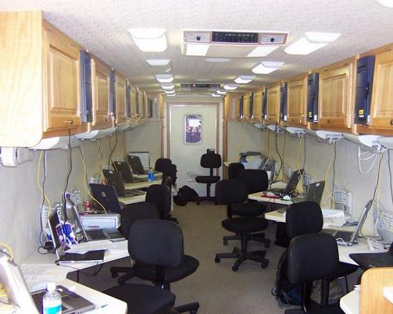 Inside the "Brain Bus" Brooks created a polygon that covered roughly the southern six counties in Mississippi and elevated it to the storm surge heights being conveyed to his team by the National Weather Service through regular conference calls. He would trace the intersection of the elevated polygon and the DEM to create a map of areas likely to be flooded. He then combined these data with the wind damage estimates being created by Mullen within HAZUS. They shared the resulting maps with the MEMA leadership and this helped to shape their response, particularly when trying to pre-position incoming rescue units. By late Sunday, Brooks had noticed that, except for using HAZUS, GIS was not really a part of the operation. "So I began to create maps that would be needed by two basic groups: individuals responding 'on the ground' and decision-makers," he told me. This included, for first responders, basic search and rescue maps that overlayed a 1 mile by 1 mile search grid on top of streets, and, for decision-makers the locations of shelters, relief kitchens, open roads, etc. He also put out a call for help, "to GITA [the Geospatial Information & Technology Association] and to every contact I knew in GIS, especially in Mississippi." Brooks, with the assistance of Delta State University students Pierre Roy and Kimani Waweru, continued preparing street and search and rescue maps for incoming rescue teams. When Katrina hit on Monday, he began working with the USCG, who would come running into the EOC with street addresses for immediate helicopter rescue missions. As street signs cannot be read from the air, the team used GIS for translation to latitude and longitude. It had to do several hundred such conversions in just a few days. At the height of the storm, calls coming into the EOC would roll over from the communications center to phones in the operations room. Brooks never knew when he answered the phone if it would be a volunteer, a request for information, or sometimes even a person in dire need of assistance on a roof that had somehow managed a call out on their cell phone. In all cases, MEMA personnel and volunteers took immediate action to resolve the caller's problem. 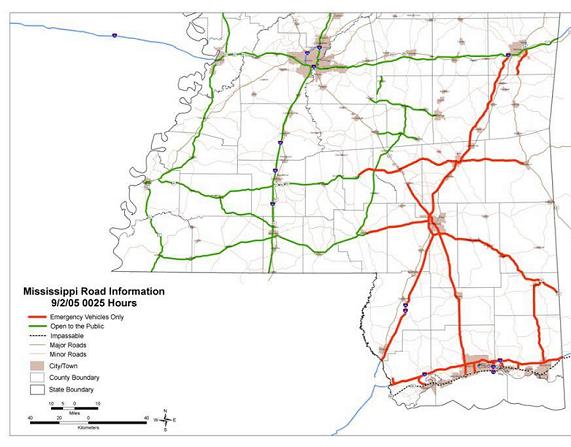 On Tuesday, August 30th, Brooks was able to get a hold of Dr. David Shaw, from Mississippi State University, who sent a mobile classroom. When it arrived in Jackson on Tuesday, Jim Steil, from MARIS, James Brown, from the Mississippi Department of Transportation, Craigin Knox, from the Mississippi Department of Environmental Quality, and volunteers from Mississippi State University worked on setting up laptops "liberated" from a recent ESRI training course at MARIS, making Internet connections, and getting generators up and running. This mobile classroom, later nicknamed the "Brain Bus", would serve as the GIS production center for weeks to come. Working with volunteers, Brooks organized a production schedule to update the maps every 6 to 12 hours with information such as the location and population of shelters, power outages, cell phone coverage status, environmental hazards, road network status, aerial imagery, and more. By late Tuesday, Brooks had connected with disaster assistance at ESRI through Mike Phoenix, Brenda Martinez, and Kieth Kite. He sent them a copy of the personal geodatabase that he had used to construct some of the early maps, with all the data that he had used, and asked them to put it into ArcSDE, ESRI's enterprise backbone for multiuser GIS. He also asked ESRI to set up ArcIMS to deliver maps over the Internet to non-GIS people. "They started working on that right away," Brooks told me. Martinez also passed the request for help along to Elhami. GIS Corps would help select and field more than 40 volunteers from across the nation through MEMA. 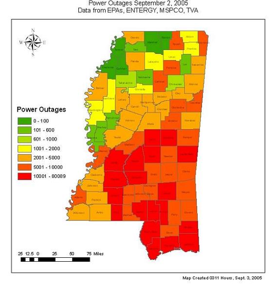 Brooks asked Elhami to provide him with two teams of people: one experienced in GIS, especially ArcMap using SDE connections, and the other experienced in using GPS receivers, especially in conjunction with ArcMap. The first team would be responsible for data development, map production, and helping to manage the whole process. This team set up shop in the Brain Bus. The second team worked on geocoding a missing persons database to create a map of last known locations and prepared to deploy south to assist the Civil Air Patrol with on-the-ground searches. In the meantime, Bob Samborski, the executive director of GITA, and others on his staff, worked to arrange for donations of GPS receivers and funnel additional volunteers to GISCorps. Through GITA, Brooks asked vendors for equipment and support. Leica, he told me, "sent several experts to Jackson with 15-20 sub-meter accuracy GPS receivers" and Garmin "donated 50 GPS receivers." ESRI, TeleAtlas and Streetmap supplied data. The arrival of the first GISCorps volunteers marked a turn in GIS operations. They began to arrive one by one Wednesday through Thursday nights, and the bulk of them arrived on late Friday and into Saturday and Sunday, September 3 and 4. Some were from ESRI and other vendors; many were from municipalities as far away as Connecticut and San Diego. They had all answered Elhami's call for help. Brooks assigned each volunteer to one of two 12-hour shifts and put them to work. "People slept where they could," he told me - and often very little. Brooks himself slept only about 23 hours in 10 days. "It was guerrilla GIS. What we ended up with was a very good state-wide coverage, but mostly focused on the southern six counties." Brooks organized the volunteers into five operational groups: 1) logistics: helping to funnel the incoming volunteers, procuring gas for vehicles and generators, keeping printers supplied and working, etc.; 2) technical support and management (operating from the bus); 3) data development and helping to scrounge up the information and load it into ArcSDE; 4) map production, including consistent symbology; and 5) GPS and related tasks — such as geocoding the missing persons database and overlaying it with a gridded search map. Brooks' "clients" included the USCG, canine Search & Rescue teams, the civil air patrol, county EOCs, the governor's office, and state agencies. The state's Department of Transportation needed maps of road closures, the Salvation Army needed to know the locations of institutional kitchens it could use, local authorities needed maps of power outages, and state and federal leadership needed maps of the area when they got there. Using three plotters, Brooks' team printed a total of more than 5,000 feet of plotter paper, acquired by volunteers from local blueprint shops. Some of these maps were displayed behind President Bush during his first press conference from the area. Two moments stand out for Brooks. One was when he fielded a telephone call from a man distraught that his mother-in-law would die if she was not rescued very quickly. He told Brooks that the woman was at the Waveland water treatment facility. The caller, however, was unable to provide a street address and one could not be found in the phone books on hand, so Brooks needed a much more precise location to give to the USCG. "We were able to use aerial photography in combination with GIS," he told me, "to extract the correct latitude and longitude." The other moment was when he felt a hand on his shoulder and, looking up after many hours of working on maps, he found himself face-to-face with Governor Haley Barbour. "It was surrealistic and it took me a minute to realize who he was," he told me. For Brooks, perhaps the most important lesson regarding GIS from this experience is that "it must be a part of the plan before the disaster happens, because it became a pretty key element and has grown since." The Federal Emergency Management Agency (FEMA), he says, was not able to produce maps "for a couple of weeks" following the disaster. For this reason, it is vital that local and state agencies be ready to go on their own. "As a federal agency, FEMA also has a different early-action role: it must get the federal machine rolling on declaring disaster areas, mapping them, and then securing assets, resources, and funds for the bigger picture," Brooks says. Designation as a disaster area unlocks state and federal emergency funds. That's necessary, he acknowledges, "but you also need more regional and local information in map format for both responders and immediate decision makers." It is much more efficient and effective, he points out, to show the governor a map of power outages than to read him a spreadsheet. When she first learned of the magnitude of the disaster, Elhami thought "I am sitting in such a comfortable place. There must be something I can do to help." She told me the story of how Brooks' call for volunteers reached her. On August 29, Brenda Martinez of ESRI, asked Elhami whether it would be OK to renew a listing for the GISCorps on ESRI's website. The next day Brooks' posted a request for volunteers on the site. Martinez spoke with him and then forwarded his request to Elhami, along with a summary of their conversation. Elhami then called Brooks. As soon as Elhami talked to Brooks, she asked him to provide her as many details as possible regarding the volunteers he needed: their technical qualifications, where they would be deployed, what the logistical arrangements would be for them, etc. When she received his answers, she asked him three follow-up questions and, in just a couple of hours, she had all the information she needed. She wrote an appeal for 20 volunteers and sent it out via URISA, late on the evening of August 31. The response was overwhelming: in the next four days Elhami received 3,100 e-mail messages. Many, she told me, were from the same people, "so nervous and anxious to go that they sent it to every address they could find." ("Actually," she explains, "they did not have to send it to either one of my e-mail accounts: when you sign up the database automatically sends me an e-mail message.") In three days, about 500 volunteers signed up officially (that is, filled out the sign-up form), while others "thought that sending a resume would be enough. We had 270 volunteers on August 28; now we have more than 900. I was reading resume after resume. I wanted people from adjoining states, with experience using ArcGIS and GPS receivers, who were stable, who had done disaster management before... I had about 30 questions for them. The database made my job so much easier; it helped me a great deal." She recruited four volunteers (including URISA board members) to screen about 40-50 resumes and rate them for her. She personally reviewed about 240 resumes and placed some onto a waiting list. She used many of the names on the waiting list for the second deployment of ten volunteers after the first group of volunteers was deployed. According to Brooks, Elhami's work of reviewing the hundreds of applications she received and selecting volunteers to send to the areas ravaged by Katrina was enormously helpful. "There was no way I could have done it," he told me. Additionally, it gave him a simple and effective way to respond to offers of help: he referred any potential volunteer to Elhami. "To me it was very calming," Brooks told me. "I knew that help was on the way." Elhami's phone number "got out," she told me, and her phone began to ring incessantly. "I talked to 60-70 people in the first three days. I told them 'It's tough out there. And hot.' I told them to bring their sleeping bags. I could feel in their voices whether they would be comfortable or not. We ended up sending a very competent group of people." Elhami credits URISA's headquarters staff for providing a lot of help: "They were absolutely marvelous, working with me throughout the first four-five days and beyond," she told me. I asked Brooks whether he received other help from remote operations. He told me that there were many — including groups in San Antonio, Texas, Redlands, California, and a Leica team working in Atlanta "to get GPS receivers dialed up correctly for use in Mississippi." Additionally, MARIS and the University of Mississippi were doing a lot of georeferencing work; Florida's Community Emergency Response Team (CERT) had deployed to NASA's Stennis Space Center and was coordinating with home agencies in Florida using Groove Virtual Office. According to Brooks, Florida authorities often had better geospatial data about Mississippi than Mississippi did and they were able to provide cadastre data from an ESRI business partner. Finally, Brooks and Elhami urged me to extend "a huge thank you!" to all the volunteers for their efforts. This is the text of the alert that Elhami sent out to the GISCorps list: GISCorps Alert This is an urgent request. If you are qualified for any of these two positions, email me as soon as you can (also attach your resume). In response to hurricane Katrina�s disaster, GISCorps has been asked to provide 20 volunteers to Mississippi Emergency Operation Center (EOC) in Jackson, Mississippi. They need two groups of ten volunteers: Group 1: Must have at least 5 years of experience and well versed in using ArcGIS 9.0 in an SDE environment, comfortable in making maps and conducting quick analysis. Experience in disaster management is a plus. Group 2: Must have at least 5 years of experience and well versed in using ArcGIS 9.0 and GPS software and equipment. **Must bring their own laptop loaded with 9.0 and also must bring a GPS unit compatible with ArcGIS**. This group will be working with search and rescue teams and K9 units mainly collecting data and navigating. The following provides some general information provided by EOC office:
GEOSPATIAL RESPONSES TO HURRICANE KATRINA Intermap has provided the Federal Emergency Management Agency (FEMA), the National Oceanic and Atmospheric Administration (NOAA), and the United States Geological Survey (USGS) with terrain elevation and imagery data of the Gulf Coast region for the Katrina rebuilding effort. The data will be made available to state, local, and federal officials at no charge through 2005. Collected in late 2004 and early 2005 the data is part of Intermap's NEXTMap USA program which is the remapping of the entire continental United States and Hawaii. NEXTMap USA will result in the most accurate map of America ever created. In addition to the pre-hurricane data, Intermap has also completed the collection of post-hurricane data over the hardest hit regions of the Gulf Coast. This new collection will provide a post-Katrina comparison of beach erosion, sand deposition, and changes to drainage patterns. The pre-Katrina and post-Katrina data sets will be extremely helpful in planning the reconstruction efforts. One of the critical factors in the planning is modeling of future storm surge events. Intermap's data will be an important asset for those modeling efforts. URISA's GISCorps has had a busy and important year. Following the Indonesian Tsunami Disaster, a group of GISCorps volunteers was deployed to assist in recovery efforts. Assistance was deployed to Kabul, Afghanistan and most recently, following the devastation of Hurricane Katrina, GISCorps mobilized volunteers to facilitate map production, data management, and other critical functions . The volunteers had an immediate impact. In light of these important contributions, URISA's conference in Kansas City, Missouri (October 9-12) will feature several GISCorps events:
GISCorps continues to accept volunteer applications in preparation for the next request for assistance from the affected region. CONTRACTS & COLLABORATIONS Tampa Electric, the principal subsidiary of TECO Energy Inc., has selected Intergraph G/Technology as the enabling engine for its geospatial resource management (GRM) environment. G/Technology provides an open database architecture that will support the integration of 15 key applications and improve data access for Tampa Electric employees, such as project planners, inspectors, drafting staff, and field maintenance teams. Tampa Electric is upgrading its existing FRAME-based AM/FM/GIS to the G/Technology system. Intergraph's services team will also provide the systems integration. The new system replaces manual processes and streamlines design, cost estimating, and scheduling activities by integrating with a company's existing design, work, and outage management systems. Intermap Federal Services Inc., a subsidiary of Intermap Technologies, has received a contract from the National Geospatial-Intelligence Agency (NGA) for Intermap's NEXTMap USA data. Intermap will provide NGA with imagery and elevation map data for regions in Southern California and Alabama. All data is available for immediate delivery. This initial purchase is valued at US$280,000. The company has completed the data acquisition of the entire state of California. With a size of more than 400,000 square kilometers, the state is the largest one it has acquired thus far. The company has also completed acquisition of the entire states of Florida and Mississippi, as well as portions of other states, including Texas, Alabama, West Virginia, Louisiana, Arizona, and Michigan. This brings its total coverage to date to more than 1,000,000 square kilometers, or more than 15 percent of the United States. Intermap's product offerings under the NEXTMap USA program include terrain elevation data as well as orthorectified radar imagery. Datasets for many areas of California are now available for purchase through Intermap's online data store, with entire datasets scheduled to be available for purchase later this year. In addition to its standard data products, Intermap provides orthorectified color imagery products upon request. GeoDecisions has recently completed the first phase of the Decision Support Environment project for the Iowa Department of Transportation (DOT). Working jointly with Bentley, the company has developed a GeoData Library (GDL) that houses the DOT's enterprise transportation data. The GDL leverages the processing services provided by the DOT's Linear Referencing System (LRS), a method to integrate various types of roadway features and roadway characteristics previously collected from different referencing systems. Additionally, GeoDecisions designed, developed, and implemented two applications — the Coordinated Transportation Analysis and Management System (CTAMS) Web and CTAMS Analyst. The systems allow users to access the data in the GDL for viewing, reporting, decision support, and in-depth analysis. CTAMS Web is available via the Iowa DOT intranet and provides the entire department with browser-based access to analyses and reports to support decision making. CTAMS Analyst offers high-end analysis functions for experienced GIS users. The second phase of the project provides Iowa DOT with maintenance and enhancement support for the system's major components — the GDL, CTAMS Web, and CTAMS Analyst. PCI Geomatics has donated its geospatial software suite Geomatica to the scientists at the Woods Hole Research Center, who will use it to assist in the production of a high-resolution National Biomass and Carbon Dataset for the year 2000 (NBCD2000), the first-ever inventory of its kind. Through a combination of 2000 Shuttle Radar Topography Mission (SRTM), topographic survey, land-use, land-cover, and extensive forest inventory data sets collected by the U.S. Forest Service, this dataset will serve as an invaluable baseline for carbon stock assessment and flux modeling in the United States. The NBCD2000 project, funded by NASA's Terrestrial Ecology Program, combines vegetation canopy heights derived from digital elevation data collected during the 2000 SRTM. The mission mapped 80 percent of the Earth's land mass with a radar instrument, producing the most complete digital surface map of Earth. In combination with the National Land Cover Database (NLCD) and National Elevation Datasets (NED), a high-resolution database of circa-2000 vegetation canopy heights, aboveground biomass, and carbon stocks for the continental United States is generated, providing an unprecedented baseline against which to compare data products from the next generation of advanced Earth observing, remote sensing platforms. Geomatica will be used for the integration and visualization of raster data sets in various formats through PCI Geomatics' Generic Database (GDB) technology in Geomatica Focus. Geomatica OrthoEngine will streamline the processes of data mosaicking and reprojection. The advanced Geomatica image analysis and modeling tools are at the core of building the raster data processing models to generate the final data sets. PCI technology can handle batch processing requirements through the EASI programming environment. The World Wildlife Fund (WWF) is using ESRI ArcWeb Services to operate WildFinder, its new information site on the Web. The site gives students, nature enthusiasts, and scientists a search tool to find and map WWF information on more than 30,000 species of wildlife worldwide. ESRI business partner Blue Raster managed the project to create WildFinder and built the customized interface that accesses the WWF database. WWF already uses ESRI ArcGIS Desktop software for thematic mapping and assessments such as its Global 200 list of biologically diverse habitats, so it looked to ESRI for a Web site solution. WWF worked with other organizations for five years to compile its Oracle database of worldwide information on more than 30,000 species. Combined with 825 identified habitat areas, the entire database contains more than 500,000 records. WildFinder visitors can type in a ZIP Code, city, country, or other location information to produce a list of animals found in a specific place. They can also search for a specific bird, mammal, reptile, or amphibian and produce global maps of its habitat range, identify its endangered status, and see links to images on the Web. The Town of Hilton Head Island, South Carolina is utilizing Pictometry International Corp.'s aerial imaging database and software. The town has a permanent population of only about 35,000 residents but is visited by more than 2.2 million people annually. Pictometry's software enables users to access up to 12 different views of any property, building, highway, or other feature in a county in a 3D-like format. The software also allows users to obtain measurements such as distance, height, elevation, and area directly from the oblique imagery as well as to insert GIS data and other data. Town government agencies, including the GIS Department, will be using the Pictometry images and software for several applications, including review of zoning amendments and variance requests by the Planning Department; analysis of wetlands, vegetation, and land use by the Natural Resources Division; viewing and documentation of violation sites by Code Enforcement officers; integration with the hurricane damage assessment process by the Building Codes Department; impact analysis of the Town's Capital Improvement Projects by the Engineering Department; development of Highway Improvement Plans and traffic accident site analysis by the town's traffic engineer; and training and incident preplanning by the Fire and Rescue Department, which plans to become a beta test site for integration of Pictometry with its Computer Aided Dispatch system. PRODUCTS Leica Geosystems has introduced GradeStar V5.0, a fifth-generation 3D grader and dozer automation system for the construction industry. The system incorporates advances in hardware and software, providing a versatile machine automation system on a ruggedized hardware platform. The new software is based on the industry standard Controller Area Network (CAN) interface and utilizes the WinXP operating system. It features a new consolidated sensor module, the GSM5, which is designed to be a central communications point between positioning sensors and the GradeStar interface. The GSM5 can be configured with an internal GPS module for space savings and ease of installation. The component design facilitates removal for exchange between machines. GradeStar V5.0 can work with Leica�s total stations and GPS positioning sensors. The system has full forward and backward compatibility with Leica�s existing 2D and 3D machine automation products, including the GS496, ProControl, SonicMaster, and MC1200, offering an easy upgrade path to the new state-of-the-art technology. GradeStar is designed as a simple tool for machine operators and site managers. Leica�s Site Manager software, together with GradeStar�s system simulator streamlines projects by allowing the user to view, check, and analyze the jobsite before starting the grading operation. System indicators can be activated and sensors switched with one touch of a button, while a live moving map guides cutting and filling operations. A universal control panel reduces operator training when moving from machine to machine. ESRI has released StreetMap Pro, a new dataset that displays commercial-level street data and is optimized for ArcGIS Desktop, ArcEditor, and ArcInfo. StreetMap Pro was created as part of the ESRI Data & Maps product family to support customer requests for enhanced street datasets to use with the ArcGIS StreetMap routing toolbar. StreetMap Pro includes the Tele Atlas Dynamap/Transportation United States and Canada street dataset Version 5.2, July 2003, as well as updated cartographic layers from Tele Atlas Dynamap / Transportation Version 7.0, January 2005. StreetMap Pro will be updated every two years, beginning in 2007. It contains more complete and current address information than StreetMap USA and is also positionally more accurate. One-way and turn restriction information ensures nationwide routing and driving directions are generated more accurately. StreetMap Pro is delivered on a single DVD. It includes complete metadata files and is configured to work with the ArcGIS StreetMap toolbar included with ArcGIS Desktop and the optional ArcGIS Network Analyst extension. CONFERENCES The Mid-Atlantic Chapter of the Urban and Regional Information Systems Association (MAC URISA) will be holding three meetings in the next few months. The first one will be on September 29, at the Rutgers Eco-Complex in Bordentown, New Jersey, on a topic to be chosen based on the responses to the Member Survey. The second one will be at the Fifth Annual NBC10 Technology and Lifestyles Expo at the Fort Washington Expo Center in Fort Washington, Pennsylvania on November 12 and 13, from 10:00 to 5:00. This event, which is free and open to the public, will mark GIS Day 2005 and highlight the efforts of the regional GIS community. The third one is the organization's 12th Regional GIS Conference, on March 15-16. On the first day the conference will feature a series of workshops around Rutgers University for GIS users at every level. On the second day the conference will be held at the Bush Campus Student Center. To volunteer for the conference contact Angela Witcher at (609) 633-2169 or at [email protected]. EDUCATION & TRAINING ESRI Press and the International City/County Management Association (ICMA) have published The GIS Guide for Local Government Officials (ISBN: 1-58948-141-0, $24.95). In the book, municipal GIS experts suggest practical approaches for incorporating GIS into city and county government. Case studies drawn from throughout North America illustrate how officials have successfully applied GIS to their specific needs — from monitoring storm drains in Hawaii to fixing potholes in Canada. In non-technical language, the book describes how to plan, fund, and implement a local government GIS for in-house functions and community outreach. It also dispels myths about GIS and peeks ahead at the technology's future. Editor Cory Fleming, a senior project manager with the ICMA in Washington, D.C., has compiled the observations of six contributing authors, all with extensive experience in local government management and GIS operations. Other government officials describe in their own words how GIS has become an indispensable tool that enhances communication and promotes efficient management. OTHER The Canadian Plains Research Center (CPRC) was recently presented with an Award of Excellence at ESRI Canada's Regional User Conference in Regina, Saskatchewan. Alex Miller, President of ESRI Canada, presented the award to Dr. David Gauthier, the representative of the University of Regina and the CPRC, for their pioneering work in the Saskatchewan GIS industry. Dr. Gauthier started the university's GIS research program in July 1985 and has since been an active researcher utilizing ESRI products. The CPRC has contributed to innovative and socially relevant projects both in Saskatchewan and internationally by providing expertise and resources in GIS. Their work on GIS projects has contributed greatly to a better public understanding of the state of the environment and how steps can be made to support environmental sustainability. The CPRC undertakes research and land resource information analysis projects for federal and provincial resource agencies, funding agencies, and private-sector firms. Clients benefit from the GIS Division's state-of-the-art technology, including the most sophisticated computer hardware and software for geographical applications. These projects have a vast differentiation of focus, yet all are critical to enhancing the understanding of the Canadian plains ecology. The CPRC's GIS services have been applied to nearly every industry, but primarily in agriculture, urban and rural land use, utilities, transportation, forestry, hydrology, parks, wildlife management, and exploration for minerals, oil and gas. Leica Geosystems' MobileMatriX has met the criteria for becoming a National Association of GIS-Centric Software (NAGCS) certified application. NAGCS certification distinguishes the product as an authorized GIS-Centric solution for mobile field data collection. Leica MobileMatriX is a field solution that extends the ArcGIS environment for the interactive processing, visualization, and maintenance of survey data collected with GPS sensors and total stations. It collects and manages spatial information within the ESRI geodatabase and dynamically links feature classes to field measurements for creating and updating maps, plans, and enterprise databases. It also provides the means for simple point navigation and engineering design construction, as well as geo-rectification of imagery from field measurements. Leica MobileMatriX is available as an add-on to ArcGIS 9 and in two stand-alone editions — Standard and Professional. The Standard Edition, based on ArcView, is ideal for common data collection tasks, which are performed through ESRI's ArcMap interface using tools designed by Leica Geosystems. The Professional Edition, based on ArcEditor, expands the capability of the Standard Edition to support disconnected editing for customers maintaining an Enterprise GIS. Leica MobileMatriX is Internet-enabled with a direct connection to the Geography Network and can be configured to connect to any IMS or FTP server for retrieving GIS data. The system can also be customized using any COM language such as C++ or Visual Basic.
Matteo Luccio, Editor GIS Monitor Ultimate Map/GIS Directory — Your search is over! GIS Monitor is published by: GITC America, Inc.
|

|
part, without prior authorization from GITC America, Inc. GIS Monitor is a GITC publication. |