Letters, Points of Interest, Kudos and Conundrums, Week in Review (Announcements, Contracts, Products, Events, Training, Hires) Back Issues, Advertise, Contact, Subscribe/Unsubscribe If, for some reason you cannot read this document, visit: http://www.gismonitor.com/news/newsletter/archive/092304.php
MapInfo announced the availability of Exponare last week. (I confess I'm finding the new product names a bit tough to remember. I know I will have trouble keeping Exponare straight with Envinsa.) On a newsgroup a MapInfo partner explained that the product was built by MapInfo Australia to replace its MapXtreme Java-based solution called The Encounter. He describes Exponare as a "RAD (Rapid Application Development) tool that sits on top of MapXtreme 2004." According to MapInfo's marketing material Exponare is a component-based suite with parts that fit together seamlessly. The clients, as I understand it, all access data from a central Exponare Server. One module, Exponare Public, offers basic visualization of data via the Internet. Exponare Enquiry offers higher-end GIS functionality aimed at users within an organization. The administrator can control access, user interface, functionality, data sets, queries, and print templates. The solution is built on .NET and requires a Windows server and client, and if using a browser, Internet Explorer. Exponare is already out in Asia Pacific, Europe, and the Middle East. Products built on top of it are already on the market in some locations. Some of the marketing material on the Web uses the Australian/UK term for local governments, "councils" and support enquiries go to an "ozsupport" e-mail address, clearly harkening back to its Aussie heritage.

Googling DWGs
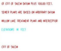
The results are pretty interesting. First off, Google tries to determine the DWG version number. Nearly everything I turned up was 1.2, 1.3, or 1.4. Others were "unrecognized." If you click on the link, you can view the file, if you have an application that supports DWG. (I don't at this time.) Or, you can download the file or alternatively, view it as HTML, which basically means, just view the text in the file. (I was only able to view files that had version numbers; those that were "unrecognized" yielded no text at all.) But, when I did see text, it seemed to retain its color. (The image at right is from a DWG map from the City of Salem, Oregon.) Ralph Grabowski did a bit more research and determined that the Google programmers simply wrote 1.2 when they meant version 12, 1.3 for 13, and 1.4 for 14. Version 1.2 was back in the stone age of AutoCAD. Google's help notes that 13 file formats are supported. DWG is not one of them. Still, Google notes that it's looking for other file types and "You may see them pop up in your results from time to time." How does Google do it? My best guess it that Google has tapped into one of the DWG libraries and now knows how to read inside the proprietary DWG format. So, what does this mean? It certainly enhances Google's ability to be used within an organization to query its library of DWGs. I vaguely recall tools like this that were offered to the AutoCAD community by third-parties. More interesting for us GIS folk, might it someday be possible to have Google look inside our map files?

Department of Corrections

"I'm so glad you asked this important question because it was just a few years ago that I was asked to help define the types of functionality GIS that would help the engineers to do their jobs more efficiently and accurately. "While working as a GIS Manager for a civil engineering consulting firm I was responsible for selling our GIS services externally as well as internally. The company I worked for was a full service engineering firm offering services in transportation engineering, land development, environmental engineering, structural engineering, transportation systems, surveying, and of course GIS. "The projects I pursued externally would be considered 'traditional GIS applications' in today's marketplace and the clients were mainly Municipalities and Regional Planning Commissions. The area that I was making great strides in marketing GIS services was to the other groups within the company where I was working. The opportunities here were growing every day as the line between civil engineering and GIS services blurred. "One service that I provided to our transportation engineering department was resource impact analysis. The success of this service went far in proving the power of GIS. In a very short time I could provide a tabulated list of all resource impacts (e.g., wetlands, property takings) for very large projects such as a corridor study. This saved the projects many billable hours and reduced lots of tedious work. "By attaching engineering data to roadway networks (a process known in GIS as dynamic segmentation) our transportation engineers could apply engineering restrictions to very large geographical roadway network areas to generate a prioritized list of projects. Data such as speed, lane and shoulder widths, sight stopping distances, accidents, access points, and pavement condition were added to the network. By using GIS the engineers could quickly answer very complex questions, that otherwise would be impossible to answer, by assigning weights to each type of restriction and performing GIS analysis. "Using aerial photography proved to be a very effective tool to identify Corridor study issues. I used GIS to geo-reference the images into state plane coordinates. After laying out the alignment and proposed corridor using [Land Desktop] LDT I would merge the two together. The story this told was very powerful. Even in GIS/civil engineering the adage 'a picture says a thousand words' is true. These plans were used to quickly identify project restrictions such as water bodies, buildings, access points, etc. and made the public hearings easier on everyone. The plans told the whole story and everyone who was impacted by the corridor upgrade would quickly understand the project by looking at the imagery as opposed to engineering documents. "Having the entire state of NH soils mapping in GIS electronic form made it easy to assist the land development group to quickly assess how the soils would impact their projects. This was a service that was provided on every large land development project during the due diligence phase and would help to quickly identify restrictions the soils would have on the projects. Another area in which I assisted the land development group was cell tower permitting. The combination of view shed analysis and civil engineering made these projects run very efficiently, reducing the permitting time. "This is a sample of 'GIS Engineering' projects that I worked on closely with civil engineers to answer complex questions quickly and accurately. As I mentioned above the line between civil engineering and GIS services continues to blur and the opportunities are boundless." � A few readers commented on my "backlinks" numbers found using Google. I wanted to use them as some sort of rough measure of "popularity." One reader found the value of 91 attributed to Starting the Hunt a bit low. He found that "if you use the link search on AltaVista you get 740 sites that link to the page!" And, he searched "Google for the 'exact phrase' www.cast.uark.edu/local/hunt and got 240 pages." Another reader shared anecdotal evidence that while it was challenging to register metadata on geodata.gov, it could be done on the Geography Network "with relative ease."
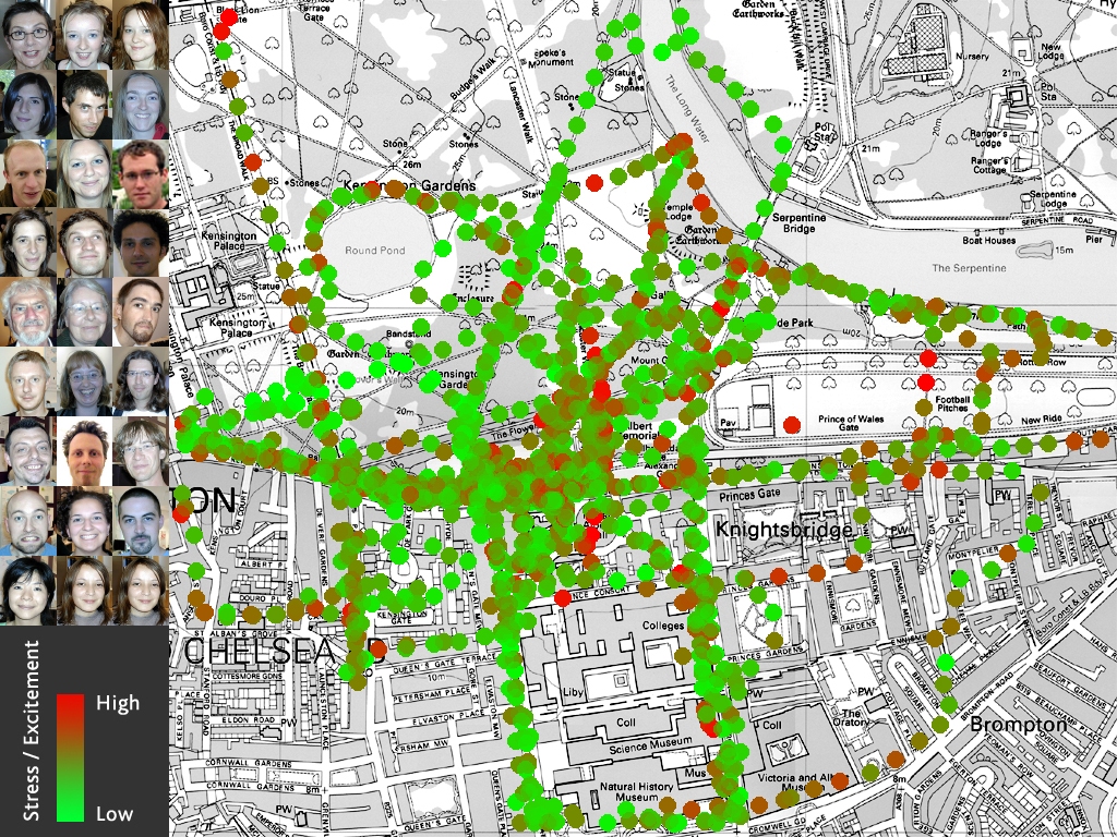
Points of Interest Electronic Compasses for the Masses. TheFeature has an interesting article on the latest technology for electronic compasses. The functionality can now be placed on a chip and that can in turn, for a few or tens of dollars, appear in your mobile phone. So what? Well, just like a cheap GPS, most phones don't know which way you are headed, unless you are moving at a decent clip. So, if you are standing still, it's tough to know "which way to go." An electronic compass on board would solve that problem. Perhaps more importantly, it would allow navigation where GPS fails (like in the cities) by keeping careful track of your distance and direction (like an IMU does in an aircraft). If you need just a distance measurement, a thermal accelerometer will do. e-Gov Update. Those behind the 25 Quicksilver Initiatives aimed at "electronicizing" federal government processes last month hired Edelman Public Relations of New York to develop marketing plans for three of them: E-Authentication, International Trade Process Streamlining, and Recreation One-Stop. Seven more are on tap for plans that will be done by December. Geospatial One-Stop was not mentioned as a candidate. In other Quicksilver news, the Office of Management and Budget is planning to hire a contractor by the end of this month to make sure all 25 e-government projects comply with all federal laws and regulations. Geospatial One-Stop is one of four initiatives preparing interagency fee-for-service agreements. An article in Government Computer News compares them to cable bills (basic and premium will be available). The final Federal Enterprise Architecture model is expected to be unveiled in the next two weeks. Map Your Mood. BioMapping is a project aimed at mapping galvanic response, a measure of stress gleaned from sensors on one's fingertips. What does it look like if you layer many people's readings? For a part of London, it looks like this (sample at right). This ties in nicely with the mobile sensors I've been reading about of late. Walkout Over Tracking. More than 250 Xerox employees have gone on strike in Australia to protest a plan to track their movements via GPS. The repairmen typically use their cars as a mobile office and maintain that they are already tracked quite enough by the company. The article from the Australian Broadcasting System did not detail how they are tracked now. Greenwich Case Moves to State Supreme Court. The Connecticut Supreme Court announced this week that the case of Stephen Whitaker of some three years ago will leap-frog the state Appellate Court and fall into its lap. Whitaker requested access to the entire GIS library (images and database) of the town of Greenwich. State Superior Court Judge Howard Owens Jr. rejected the town's argument in a Dec. 30, 2003, decision that providing the data would endanger residents. The appeal by the town will be heard in the Supreme Court, perhaps as early as next month.
Kudos and Conundrums Kudos (concepts we applaud) Help Locate Friends in a Crowd. Bluetooth has been criticized at times for its short range. But MeetingPoint uses that short range limitation to good advantage. The free software allows two people with Bluetooth devices, who have set up a defined channel, to set an alarm should they be within Bluetooth range of one another. The idea is to help people find others they may not yet know by sight in crowded bars or at crowded events. That's kind of cool - I had to work pretty hard at one point to track someone down in the Map Gallery at the ESRI conference. The best thing about this app, noted on the website, "accessibility support for blind and vision-impaired people is planned." Conundrums (concepts we question/give us pause) Donating RFID Readers. The folks at Digital Angel are donating RFID readers to animal shelters in Florida to help track pets lost or injured during the recent hurricanes. That is one of the challenges about the tags: no one can read them without a scanner. Moreover, how do you know the animal has such a tag? Do they wear tags about the tags on their collars?
Please note: Material used herein is often supplied by external sources and used as is. � Announcements MicroStrategy Incorporated, a provider of business intelligence software, announced a new strategic alliance with MapInfo. The solution integrates MapInfo's sophisticated geographic querying and visualization capabilities with MicroStrategy's business intelligence (BI) platform, and allows organizations to efficiently monitor, report, and analyze their enterprise data. Aerial photography company, BlueSky, can now supply the latest satellite imagery following an agreement signed with European Space Imaging. Governor Bill Owens has proclaimed October 4-8, 2004, as Geographic Information Systems (GIS) Week in the State of Colorado. Letters of Interest are being accepted until December 2004 for first use of RADARSAT-2 data. Documentation for the proposal submission process is available online. TDC Group developers of Freeance and the Web GIS hosting firm BinaryBus announced a strategic partnership in the geographic information systems industry. The companies will leverage BinaryBus's ArcIMS Web GIS hosting services and experience with TDC Group's Freeance, an ArcIMS management software, to provide Web mapping to organizations interested in the security and low cost of offsite ASP-hosted GIS solutions. ESRI announced its support of the Mesoamerican and Caribbean Geospatial Alliance (MACGA), a program implemented by the United States Geological Survey (USGS)/EROS Data Center in cooperation with several partner organizations. ESRI is providing geographic information system (GIS) training, documentation, and software grants to assist the alliance. Traftools offers traffic responsive driving directions for greater San Diego County. Traffic responsive driving direction is a shortest time driving direction from origin to destinations that avoids major accidents, incidents, and congestion at major bottlenecks. From the website: "These maps are presented as GIS." "These maps are presented using ESRI ArcIMS, a wonderful software for distributing GIS based map via the Internet. The maps courtesy GDT- Geographic Data technology." Bentley will be adding JPEG 2000 support to its products by using ERM's ECW JPEG 2000 Software Development Kit (SDK). Laser-Scan announced that IME UK Ltd is now a reseller for Radius Topology in Scotland. RMSI, a global IT services company, announced that for the second year in the running, RMSI has been ranked amont Indian IT's 'Top 20 Best Employers', in the DATAQUEST-IDC "Best Employer Survey 2004." RMSI which entered the ranking last year at number 19 moved up three positions this year to feature at number 16 in the 2004 survey. � Contracts and Sales Intermap Technologies, in conjunction with Aero-Metric announced that they have received a subscription contract from the National Oceanic and Atmospheric Administration (NOAA) for Intermap's NEXTMap USA coastal data. The NOAA Coastal Services Center (NOAA CSC) is managing the program. Under the contract, Intermap will provide NOAA with NEXTMap USA imagery and elevation map data for regions in Florida, Alabama, Louisiana, and Mississippi. This is the first phase of a planned multi-year program that is anticipated to include the purchase of NEXTMap data for the entire coastline of the continental United States. Intermap's portion of this phase I contract is valued at approximately $690,000 (USD $522,000). Varion Systems, the software development and value-added reseller division of GeoAnalytics, Inc, has been chosen by Pottawattamie County, Iowa to implement Govern Software's land management software suite, which includes integration with Varion's Web-GIS portal product PV.Web. GAF AG, an internationally active geo-information technology company, has been awarded a contract by the Worldbank to set-up a "Satellite Imagery and Data Analysis Study along with required Ground Truth Work and Meteorological Monitoring" to support the "Sana'a Basin Water Management Project" (SBWMP). The project aims to assist the Government of Yemen in slowing down depletion of groundwater in the Sana'a Basin aquifer and to gain time to convert the Sana'a Basin economy to less water-intensive activities and encourage out-migration. PlanGraphics, Inc. has been subcontracted by the engineering firm of CH2M Hill to provide GIS implementation services to the Northeast Ohio Regional Sewer District (NEORSD) in Cleveland, Ohio. Laser-Scan announced that Forestry Tasmania has purchased Radius Topology. Intergraph Mapping and Geospatial Solutions, Benelux B.V., announced a $3 million (U.S.) signed contract with ISC, ICT-Service Cooperation Police, Justice and Safety. Intergraph will spatially enable the geospatial emergency response system for the Netherlands' 26 departments for the police emergency response services, called the Sherpa project. Harrow Primary Care Trust (PCT) has invested in MapInfo HealthPro, an integrated mapping solution that allows location-based intelligence to be analyzed and then shared across the organization, thereby revealing trends and informing the decision-making process regarding service delivery. RAINS (Regional Alliances for Infrastructure and Network Security), a private/public partnership dedicated to accelerating the adoption and deployment of homeland security technologies, announced that its Connect & Protect program has secured $200,000 in state grants of federal homeland security funds from the Oregon Office of Emergency Management (OEM) and Multnomah County Emergency Management (MCEM). � Products
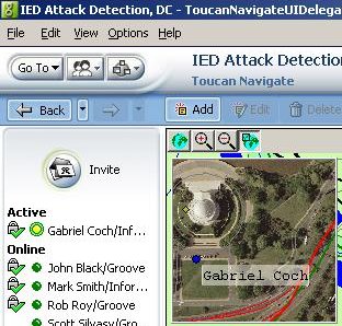
Information Patterns shipped Toucan Navigate v2.0, the second generation of its collaborative Geographic Information System software for Groove Virtual Office. Toucan Navigate brings distributed and mobile teams together for jointly reviewing and acting upon location-sensitive situations, taking full advantage of Groove software's industry-leading collaboration capabilities including data synchronization, presence, and activity awareness. DonationChannel Inc. and InfoUSA Inc. announced the addition of InfoUSA's Yellow Pages content to the increasingly popular RealBird Enhanced Viewer, a Web-based aerial maps viewer and GIS tool targeted for real estate agents and brokers. Also part of the agreement is an affiliation allowing DonationChannel to resell InfoUSA sales leads lists to its Realbird member agents. The Enhanced RealBird Viewer costs only $100/year. Red Hen Systems Inc. released GeoVideo, a new extension to ESRI ArcGIS (versions 8.x and 9.0) that enables users to integrate DVD video into interactive maps. Mapping Solutions LLC announced that its flagship product Map-In-A-Box for MapInfo Professional has been updated to include seamless access to the high resolution color orthographic aerial images recently made available by Microsoft's TerraServer-USA Web portal. Thales introduced the Magellan RoadMate 300. Available in North America in November 2004 the RoadMate 300 is a color touch screen vehicle navigation system that offers turn-by-turn text and voice-prompted street navigation for use in any car. New data can be added. Multimap, one of Europe's online mapping companies, announced that drivers can now view at a glance where their journey crosses London's Congestion Charging Zone, when searching for directions on Multimap.com. That could save them money. The Geo Shapefile Importer, developed by My3D LLC, provides an easy, robust mechanism for importing ESRI Shapefiles into Geo PRO - a 3D Modeling and Animation package for Visual Simulation. � Events
Not to be outdone, just a day or so later, the Open Geospatial Consortium (OGC) (formerly the Open GIS Consortium), announced that OGC members exhibiting at the September 26-29 SPATIAL-TECH 2004 symposium and exhibition will participate in an exhibition floor interoperability demonstration. The New England ASPRS' next Technical Meeting will take place at The MathWorks Company in Natick MA, on Sep. 30 at 7:00 pm. MathWorks is the developer of technical computing software including MATLAB and Simulink. RSVPs are requested. Please e-mail Russ Congalton at russ.congalton(at)unh.edu � Training DeLorme announced the successful introduction of XMap/GIS Editor training to the curriculum at FEMA's National Fire Academy. � Hires Dr. Carl Reed was appointed Chief Technology Officer (CTO) of the Open Geospatial Consortium. George Percivall, most recently of NASA, has joined the OGC as Executive Director, Interoperability Architecture. Mark Reichardt was appointed to the newly created position of President & Chief Operating Officer. In this capacity Mr. Reichardt will assume day-to-day operational management of the company and responsibility for implementation of the corporate business plan. In his new position Mr. Reichardt is also appointed to the OGC Board of Directors and will serve on the board's Executive Committee. Daratech, Inc. announced the hiring of Peter D. Littleton to the position of Director, Corporate Development, where he will spearhead Daratech's expanding business lines, stepping up its marketing and growing sales. He has experience in "geospatial industry segments including CAD/CAM, PDM, Architecture, Engineering and Construction, Plant Creation, and operations." He once worked at GDT. Demetrio P. Zourarakis has been appointed remote-sensing and GIS analyst, technical lead for the NASA-funded Kentucky Landscape Snapshot and Census Projects. SRC LLC, a provider of micromarketing technology solutions, announced it has appointed Ed John as Vice President of Sales and Field Operations. Most recently, John served as a principle founder and Managing Director for SpatialPoint LLC, a Microsoft Certified Partner involved in the integration and extension of the Microsoft MapPoint platform. In addition to his experience at SpatialPoint, he has held key industry positions as vice president of sales and marketing at Empower Geographics and as a sales manager and director within MapInfo's Telecommunications team. Forte Consulting Ltd. announced that Graham Morgan has joined the firm as a Managing Partner. Based in Victoria, British Columbia, Graham will be involved in senior level consulting assignments and directing Forte's operations.
Advertise With Us
Contact GIS Monitor is published by: GITC America, Inc.
Subscribe/Unsubscribe |
