Letters, Points of Interest, Kudos and Conundrums, Week in Review (GEOINT, Announcements, Contracts, Products, Events, Training, Hires) Back Issues, Advertise, Contact, Subscribe/Unsubscribe If, for some reason you cannot read this document, visit: http://www.gismonitor.com/news/newsletter/archive/101404.php
GEOINT: A Different Kind of GIS Conference
After quizzing a few attendees and vendors about "what's different" between the two worlds when it comes to "what they need," I've come to the conclusion that both groups respect the benefits of use location as an organizing and managing principle for data. But, on the INTEL side, "more" is the difference. INTEL-focused geospatial users simply need "more." More what? More data, updated more frequently. More speed. More integration. More collaboration. More consistency. More types of algorithms. More flexibility. To travel in this new world, I learned quickly, you needed a bit of new language. There are some acronyms that are helpful, but the most valuable terms are the ones that divide up the "intelligences" that are the essence of this group's work. I was lucky to literally have someone whispering in my ear during the keynotes so I could follow. Later, Matt Tate of Intergraph helped me formalize my understanding. SIGINT is signals intelligence and refers data in "signals" or messages. ELINT is electronic intelligence and refers to data collected by electronic sensors. IMINT is imagery intelligence, data in pictures. HUMIT is human intelligence, the kind picked up by people on the ground, around the world. MASENT is Measurement and Signature Intelligence data collected in the "ether," that is acoustic or in the air. It's sort of "every else" that doesn't fit in the above categories. And, of course, all of these data points are collected at, or refer to things happening at locations. And, that's where intelligence intersects with geospatial. The good news is that, to GIS folks, that's a no brainer. In this community, it seems, it's even less of a no brainer, if that's possible. Said another way, you don't have to sell intelligence people on the importance of location; they get it.

Before the introductions, an honor guard presented the colors and we stood for the National Anthem. I can think of but one other conference where this happened: one on homeland security not too long after 9/11. Stuart Shea, the president of USGIF, the organization behind the conference, welcomed the crowd. He alluded to the hot topic of conversation the night before at the opening reception: which version of the bill to reorganize U.S. intelligence would ultimately pass, the house or senate's? He noted the evolution of the type of threat against the county. It was once one of a "button" but now is mobile, distributed, and far harder to find. George Tenet was introduced and immediately stated that there was no need to tell the assembled crowd about the importance of geospatial intelligence. But, he proceeded to do just that, noting among many other factoids that 80% of General Tommy Franks information used during his leadership in Iraq was from the National Geospatial-Intelligence Agency (NGA). Tenet was at his best when he took a broader perspective on geoint and his role as Director of Central Intelligence (DCI) for seven years. (I didn't know this but in the seven years before him, there were four different people in that job.) He talked about how the agency is regaining the respect it deserves and noted that 138,000 people applied for the 2,000 spots in recent years. He noted that he'd kissed Arafat more times than any other senior official. He was frank about inconsistencies and gaps in the intelligence on Iraq's weapons of mass destruction and explained that it was too painful to go through the failures on Iraq. Clearly he wanted to use what came before to help shape what is to come; he wanted to look forward. That was interesting, especially since he is not participating in the reorganization of the nation's intelligence assets. Based on what he shared with us during this talk, that disappointed me. Some other snippets: Intelligence agencies should "never break faith" with the American people. People are intelligence's greatest asset. Terrorism will direct the next generation of intelligence leaders. He told the story of the foreigner who helped in the capture of Khalid Sheikh Mohammed, the alleged mastermind of 9/11. That person wanted to know if the president knew of his contribution. Tenet assured him the president did, though of course no one would ever know his name. Tenet asked him why he chose to risk his life to help the U.S. to capture Mohamed. His answer: to free the world from those who misrepresent his religion and kill innocents. This man, said Tenet, bought the very first suit he ever owned, for their meeting. Tenet highlighted the role of intelligence in the recent success with Libya on nuclear arms. Intelligence made the "no shots fired" resolution possible. And, he quipped, when Libya was ready to talk, it didn't call Michael Moore, but British and U.S. intelligence. He noted that "history matters." I noted the slight irony of that statement at a conference based in geography, but he clearly was aiming to look ahead. Terrorists return to plotlines, even ones that are not completed the first time. The reference to these plans as "plotlines" sent a chill through me. Tenet explained that "Al Qaeda" means "the base" in Arabic and that it's not a group, but a movement, one fed by countries with populations that are growing and can't provide education and jobs for its people. The intelligence world keeps an eye on that big picture, too. Much of the cooperation with other countries on terrorism and other matters is driven by intelligence. Tenet noted that intelligence was key in confirming AQ Kahn's participation in moving uranium centrifuges to North Korea, spurring action on that matter. That's a story you won't hear, he confided. The shelf life of a Washington secret is about 30 seconds. He described the upcoming reorganization of U.S. intelligence as feeling like there was a patient on the operating table with twelve people around him, none of which had gone to medical school. He recalled the dearth of funding and the flight from intel of many of the best and brightest in the 1990s. We can never let that happen again, was the message. The investment must continue to be made in human, technological, and analytical areas of intelligence. He wrapped up with a number of what I look at as pearls of wisdom for the future: - We need defensive and offensive intelligence (before 9/11 there was no defensive to speak of). (I'll include more on other presentations next week.)

On the Floor Sensor Systems presented the latest version of its imagery solution, RemoteView. This is one company that is squarely in the intel space, one I'd not run into on the civil side. The company prides itself on its tools to help those who are "drinking from a digital fire hose." It helps users find and get at their imagery. While many other systems require preprocessing to fly across 3D data, Sensor Systems combined imagery and DEMs on the fly. Another hot topic here was its "virtual GPS" - using the system to determine coordinates for targeting. The solution offers image analysis tools, but limits the options, in a sense, preventing a "fire hose" of functions from overwhelming the user. The result? Training is but two days.
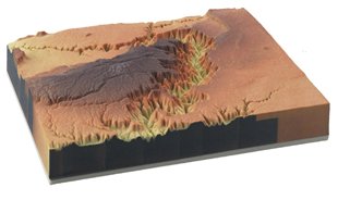
ZCorporation was showing off its 3D models printed using a standard HP printer head. Instead of ink, the printer puts down a film, layer by layer, in color (if you like) to build up a 3D surface model, a landscape, or even a juice bottle. My favorite part? These are not fragile "do not touch" objects but solid "please touch" objects. And, the models can be driven directly from GIS or CAD data. Hottest thing on the floor? It was a touch table, but not the one displayed at the ESRI conference. No, this table, from Mitsubishi Electric Research Laboratories (MERL, up the road from me in Cambridge, Mass.) is smarter. It's truly multi-participant. Recall that on the Northrop Grumman table one user can take control from other and "drive." That can't happen with this table. I sat down with three other users, including another neighbor from Cambridge. We each opened our own window with our fingers and zoomed in to the same image. My window was yellow, and each successive window I opened was also yellow. And those were my windows. If the fellow opposite me tried to mess with my window, the system ignored him. In the window I could zoom and pan (a clever bar on the side of my window told me how much more zooming I could do before I hit the maximum resolution) and do a mark up. I could save windows to use later. So how does it work? Basically each user is "charged" by sitting on a "hot" stool. That allows the system to keep track of whose windows are whose. Moreoever, it means this is not a touch table where any touch counts. Only "hot" touches count. So, a glass of Coke put on the table (I didn't do that, the folks from MERL did!) didn't have any impact. The MERL folks were showing off the tool with a Java app built with Idelix's Pliable Display Technology (PDT) toolkit. We were actually using PDT lenses to look at the image. Idelix was also showing off a new implementation of PDT in RSI's software. The work, funded by the Special Projects Office of NGA's Enterprise Directorate will incorporate PDT into the client side of RSI's Image Access Solutions (IAS). That means, in a nutshell, that a wired or mobile client will get a JPEG 2000 low res image from a server. And, by using the lens, determine an area of interest. Only then will the more detailed information, just that small bit of it, be delivered to the client. LizardTech's latest version of GeoExpress, 4.1, now supports JPEG 2000. But, this being the intelligence side of geospatial, the company was quick to point out its support for the Department of Defense flavors of JPEG 2000: NPJE and EPJE. That's right, there are different profiles of JPEG 2000 depending on what you want to do with the image. The good news? Users just have to check which flavor they want, and the software will build it. On the flip side, while the different profiles are different, any correctly implemented JPEG 2000 software can read any valid version, it just might not take advantage of some of the data included.
The opening reception was a bit different than other GIS events I attend. Walking to the aquarium, where it was held, I heard many terms I don't use everyday: "cost plus" "NGA has not blessed that yet." At registration, I was asked, I believe for the first time, what hotel I was staying at, and for how many nights. I was also asked on what airline I traveled. This event is run like a business. I sort of expected to need an ID to register, what with all the government types in attendance, and George Tenet speaking on Wednesday. It was not needed. The name of the United State Geospatial Intelligence Foundation is quite hard to say in one breath. Most speakers put a pause after "geospatial." It sort of needs a "breath mark" like one sometimes sees in music. While George Tenet spoke, the two secret service people on my side of the room kept their hands clasped in front of them and looked around. Every now and again they spoke into their suit coats' cuffs. Why is this event different than others? Said one exhibitor with a grin, "There's money here!" Exhibitors were unanimously pleased with the turnout and the "quality" of the attendees. They were the decision makers with money in their pockets. The booth that everyone talked about? NGA's. One half had 1/8 of a globe with mirrors and a high tech projection system. As screens overhead told the story of NGA, the imagery on the globe changed. The other half of the booth had demos running. It was the fanciest booth there and rivaled presentations I've seen at science museums around the country. Several people noted to me, "Your tax dollars at work!" I was a bit overwhelmed by acronyms, so I was pleased to hear one of the more senior execs in this industry refer to one session as "alphabet soup." In the presentations, speakers were very informal, referring to Bill and John and Charlie. This is a tight knit community and the collegiality was pleasant. Still, it was hard for me to keep people/titles and last names straight!
Letters � Duane Marble correctly criticized an oversight in my note about MapMemo last week in the Kudos section. "It would have been helpful to state explicitly that MapMemo (looks � Randall Newton, editor of A-E-C Automation Newsletter shared a few tidbits he found relating to geography. First off, he pointed me to The Institute of the Future's latest conference: New Geography: Strategies For Deep Place. A blogger notes that David Rumsey, Howard Rheingold (SmartMobs) and others participated. Is this the new AAG? Second, Newton provided a heads up on a new O'Reilly book on Mapping Hacks due out later this year. � Longtime reader Atanas Entchev of Civil Solutions shared his take on the latest Multimap Web mapping features. The "Cool UK site overlays semi-transparent USGS-like [actually Ordnance Survey -Ed.] map over aerial photography. Move your cursor over the map." It is cool - and GlobeXplorer had it here in the US last year. Atanas also noted that Bloglines, an RSS provider offers The Ultimate Map/GIS Directory via RSS. Alas, the material is several months old. The organization did this without contacting me. � Ralph Grabowski has been trying out Voice Over Internet Protocol (VOIP) up in Canada. He notes that the system really makes area codes irrelevant. "Talk about area codes no longer related to geography! In theory, I can take the D-Link box with me on trips to anywhere in the world, plug it into any high-speed Internet Ethernet connector, and make calls to back home free. Or, for 5c/min long distance. "There was a catch: the phone company could not give me a local phone number. So, my VoIP phone number is local to Vancouver, which is long distance from my town... That means that all "local" calls are long-distance calls." The editor replies: That raises another issue about VOIP: the ability of 911 to locate a caller. That's one of the few current "red flags" about the service I've seen. I understand there is work underway to provide solution.

Points of Interest Manifold Conference. That's right, the folks at georeference.org are organizing the first ever Manifold User Conference for November 18 and 19 at Cornell in Ithaca, New York. The two-day event features a look at what users are doing, the future of the software and many opportunities for user input. And, it's affordable. Details on online here with registration here.
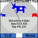
Political LBS. A Java program that can be run on some GPS-enabled or non-GPS-enabled devices with Internet access, literally determines the Republican or Democratic leanings at the devices location. It does so by grabbing the location via GPS or having the user key in an address. With that in hand, it determines an optimal radius for a search and taps into a database of political contributions for that area. It then reports how red or blue the area is. I suppose it's a fun proof of concept, but hardly a killer app. The author, the chief technology officer of a New York City ad agency put the app together "to keep the discussion going." Download info and images are available here. (Last I looked this website was having bandwidth issues. I suspect it was overwhelmed by mentions on blogs.) All Places are not Equal. France's industry minister agreed to a new law permitting cinemas, concert halls, and theaters to use cell phone jammers. The only limitation? Emergency calls must not be blocked. It's been a request from movie theatre owners for some time. I wonder if this will get to the U.S. anytime soon? Quote of the Week. "Everyone who's going to buy a GIS system already has one," that's the word from David Sonnen, at IDC. His company reports that the market for GIS software, maintenance, and support has stalled in its growth, and is staying flat at $1.6 billion in 2003. Sonnen was quoted in Washington Technology. But fear not, there's still money out there for the integrators. "Integrators probably do 2.5 times the business that the software people do. By spreading GIS information out across other information systems, they make those systems more useful." The article is actually about Farallon Geographics' use of GIS in San Mateo County for getting out the vote. That story was also covered in Wired and eWeek. I think it's great the story is getting non-GIS publication coverage. (The story was submitted to GIS Monitor earlier this year.) SPIT! The open nature of VOIP-based calls makes it easy for spammers to send audio-commercials to people's VoIP voice-mail inboxes in much the same way they invade our e-mail inboxes. The acronym for the problem is SPIT, for spam over Internet telephony. There's a movement afoot to stop it before two many folks jump into VOIP and SPIT becomes profitable enough to be widespread.
Kudos and Conundrums Kudos (concepts we applaud) Got Slurpies? 7-Eleven will begin using handheld computers in all of it stores, to among other things, predict demand for perishable food. Using data on weather (hot = more Slurpies) and other factors, the hope is have more in store of what customers want and have less go to waste. My local supermarket needs this. It always has discount overripe bananas� Conundrums (concepts we question/give us pause) GPS for the Senate�and the Rest of Us? According to Federal Computer Week, "Officials at the Senate Office of the Sergeant at Arms and Doorkeeper have issued a request for information for Global Positioning System devices in vehicles." I understand that's for managing the cars of the senators? In perhaps related news, a research company has exposed the plans of Intelligent Transportation Systems Joint Program Office, to put tracking devices in U.S. cars for a variety of purposes. The work is funded to the tune of $4 billion and is secret, says Creative Loafing who wrote the report.
� GEOINT LizardTech announced GeoExpress 4.1 with MrSID at GEOINT 2004 Symposium in New Orleans, Oct. 12-14, which now supports encoding to JPEG 2000. GeoExpress 4.1 includes easy-to-use image profiles that simplify the creation of JPEG 2000 imagery in U.S. Department of Defense standards such as NPJE and EPJE formats. The company states that GeoExpress 4.1 is the first commercial JPEG 2000 application geared specifically towards large geospatial imaging implementations. Harris Corporation will directly maintain, support, distribute, and enhance its MET multi-image exploitation tool and any derivative products beginning January 1, 2005. The National Geospatial-Intelligence Agency (NGA) has announced that after the end of 2004 it will no longer provide MET under Special Purpose Rights licenses at no cost to image exploitation users and analysts. Harris plans to release METv3.0 during the spring of 2005 on both the Solaris and Windows platforms. Harris also announced InReality Analyst Edition -- the newest version of its line of InReality visualization software modules. Analyst Edition offers users a more powerful viewing application and enhances the value of 3-D models by expanding their use across a variety of applications. Intergraph introduced GeoMedia Image Scout, a new product for advanced image exploitation that analyzes and intensifies multi-source geospatial data. Available immediately, GeoMedia Image Scout enables quick and accurate broad area search operations of digital imagery using geospatial fusion. IDELIX Software Inc. and RSI (Research Systems, Inc.) announced that the Special Projects Office of the National Geospatial-Intelligence Agency (NGA) Enterprise Directorate has funded the integration of Pliable Display Technology (PDT) by IDELIX into the client software applications of RSI's Image Access Solutions (IAS). � Announcements The United States Geospatial Intelligence Foundation (USGIF) added the National Geospatial-Intelligence Agency (NGA) and USA ERDC Topographic Engineering as sustaining members. Membership is now at 47. UCLID Software announced that it now provides GIS services including data conversion, geodatabase implementation, and GIS training. ESRI and Trimble announced the winners of the 2004 ESRI and Trimble Mobile Government Grant Series. Raytheon Co. acquired Photon Research Associates Inc. of San Diego, Raytheon officials announced last week. The terms of the transaction were not disclosed. PRA will be a wholly owned subsidiary of Raytheon, reporting to Raytheon's Space and Airborne Systems. RMSI has become an Oracle Technology Partner. Mircea Baduts, a GIS/CAD consulting engineer in Romania, has a new book, GIS - Practical Fundaments which was recently published in Romanian. Tripod Data Systems (TDS) will provide a complimentary copy of its TDS COGO for Pocket PC surveying software-a $99 value-through the TDS website. The product can be downloaded after some registration information is provided. Ordnance Survey is to launch an enhancement to its detailed digital height data defining the physical landscape of Britain. The national mapping agency is extending its Land-Form PROFILE product to include enriched digital terrain model (DTM) data for a selection of urban areas and flood plains. Land-Form PROFILE Plus will enable nationally consistent 3D modeling applications for activities such as flood risk insurance assessment, highway and pipeline planning, and environmental impact analysis. Um, didn't Intermap already do a product for insurance funded in part by the industry? NextMap Britain? ESRI and Earth Satellite Corporation (EarthSat) announced that ESRI is a reseller of EarthSat's NaturalVue and GeoCover 15-meter (0.5 arcsecond) pixel resolution data sets. Laser-Scan announced that KOREM has signed an official reseller agreement that enables them to resell Radius Topology in Canada. The Surveying Special Interest Group (S-SIG) gives surveyors, geographic information system (GIS) professionals, and those with a general interest in a survey-related field the opportunity to work together toward integrating surveying and GIS technology. � Contracts and Sales MWH Soft, Inc., a provider of water resources applications software, announced that the Water and Sewerage Authority of Trinidad and Tobago (WASA) has deployed multiple licenses of MWH Soft's H2OMAP Water Suite software to drive its comprehensive water facilities master plan. Bentley Systems announced that ACCIngenieria, a Colombia-based civil engineering firm, has selected Bentley's Haestad WaterGEMS hydraulic modeling software for application in major water distribution projects in Colombia. Vexcel Corporation has been awarded a contract by the National Geospatial-Intelligence Agency (NGA) to demonstrate volumetric imaging through tomographic SAR technologies. Widely considered to be the next step in the evolution of radar imaging, SAR tomography offers the promise of accurate 3D earth imagery as well as the ability to penetrate forest canopies to characterize both the foliage and the underlying terrain. Pictometry will provide new imagery of the city of Philadelphia in the spring of 2005. The city has renewed its license. � Products New versions of the Pliable Display Technology (PDT) Software Development Kits are available from IDELIX Software Inc. They include developer tools: PDT C++ SDK 3.1 and PDT Java 2.0. Sensor Systems released RemoteView Professional version 2.4.1 for Windows. RemoteView version 2.4.1 increases analytical capability to rapidly create situation awareness over broad areas incorporating vast amounts of image data. Oak Ridge National Laboratory is pleased to announce the release of LandScan 2003 Global Population Database. The LandScan data set is a worldwide population database compiled on a 30" X 30" latitude/longitude grid. Census counts (at sub-national level) were apportioned to each grid cell based on likelihood coefficients, which are based on proximity to roads, slope, land cover, nighttime lights, and other data sets. LandScan has been developed as part of the Oak Ridge National Laboratory (ORNL) Global Population Project for estimating ambient populations at risk. The LandScan files are available via the internet in ESRI grid format by continent and for the world, and in ESRI raster binary format for the world. This version of LandScan represents the fifth version of LandScan and succeeds the previous versions. LandScan 2003 is free of charge to Federal Government institutions, educational institutions, and global organizations including the United Nations. All other organizations and companies must license LandScan 2003 directly from ORNL. eNeighborhoods, the nation's premier compiler of home and neighborhood information, has unveiled the newest feature addition to its line of Internet real estate marketing solutions: instant aerial and satellite photos from GlobeXplorer. � Events The Geospatial Information & Technology Association's (GITA) announced that its 2004 GIS for Oil & Gas Conference and Exhibition broke several significant records during the three-day event, held Sept. 20-22, 2004, at the JW Marriott Hotel in Houston, Texas. The 13th annual conference attracted a total of 659 attendees, breaking the event's attendance record set in 2002 by more than 12 percent. Registrations by user attendees, totaling 249, increased dramatically-by nearly 53 percent-over the record set in 2003. Finally, the exhibit hall was host to a record 55 companies. Consider this: a focused show gets larger, while more general conferences are, in general, getting smaller. Hmmm. All six New England states and New York will participate in GIS Day on November 17, 2004. Debating issues around the mass-market consumer adoption of location-based services (LBS) is the focus of a free one-day seminar at Ordnance Survey's Southampton Business Centre. It's November 2 in Southampton. The Geospatial Information & Technology Association (GITA) will present its 28th annual conference, Crossing Boundaries, March 6-9, 2004 at the Colorado Convention Center, Denver, Colorado, USA. (That's the same week as ASPRS in Baltimore.) � Training � Hires Image Africa Ltd, a UK founded satellite imaging company, has set up its head office in Nairobi, Kenya and has been welcomed as a new investor in Kenya. GeoDecisions named Jason L. Gleason geographic information systems (GIS) analyst for the firm's Pittsburgh office. Daratech announced the hiring of Harvey Kaplowitz as Executive Director of Conference Productions where he is responsible for designing, developing, and producing Daratech's executive-level conferences addressing PLM challenges in discrete manufacturing and the process & power industries.
Advertise With Us
Contact GIS Monitor is published by: GITC America, Inc.
Subscribe/Unsubscribe |