

2006 October 12
This issue sponsored by
ESRI
Contents
- Editor's Introduction
- Visual Learning Systems Ships LiDAR Analyst 4.1
- Book: A to Z GIS
- Briefly Noted
- Department of Corrections
Departments
If, for some reason, you cannot read this document, please visit:
http://www.gismonitor.com/news/newsletter/archive/archives.php?issue=20061012
Editor's Introduction
This week I visited the offices of Visual Learning Systems (VLS) in Missoula, Montana, and interviewed the company's president. In this issue I also bring you a few other tidbits and my usual round-up of news items from press releases. Tomorrow I will be in Portland, Oregon, at the Government Open Source Conference 06; I will report on that conference in next week's issue.
— Matteo

Visual Learning Systems Ships LiDAR Analyst 4.1
Ten days ago, Visual Learning Systems (VLS) began shipping version 4.1 of its LIDAR Analyst automated feature extraction software for ArcGIS. According to the company, the product's new capabilities include the extraction of complex 3D roof geometry; faster and cleaner extractions of 3D buildings; enhanced bare earth extraction, modification, and DEM editing tools; revamped tree and forest region extraction workflow; the ability to read, classify, and write .LAS format point cloud files; smart 3D editing tools for buildings; the ability to edit and crop point cloud files; and automated attribution of features—such as height, area, perimeter, and crown width.
Yesterday, at VLS' offices in Missoula, Montana, I discussed the company's history, technology, and vision with its co-founder and president, Dr. David Opitz. Then Bill Veteto, a GIS analyst, demonstrated for me various capabilities of the company's products.
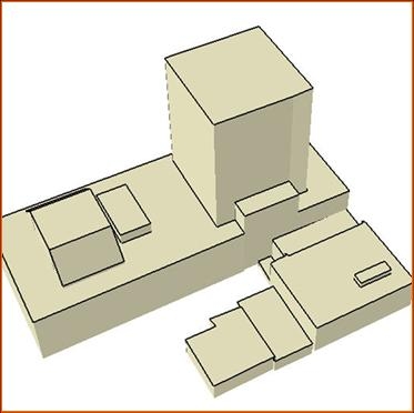
Extracted 3D shapefile
Opitz, a native of Montana, did his graduate work at the University of Wisconsin, specializing in artificial intelligence and machine learning, then started his career as a professor of computer science at the University of Montana in Missoula, where he ran a machine learning research lab. One of his early research projects, funded by NASA, was to automate the identification of volcanoes and craters on Venus. Opitz then joined with Stuart Blundell, who had a GIS company in Helena, Montana; together they worked at commercializing this technology and won a few SBIR (Small Business Innovation Research) contracts from NASA's Jet Propulsion Laboratory (JPL) and the Department of Defense. In Phase I contracts the company demonstrated its ability to find such features as roads, buildings, and land cover and that led to Phase II funding from NASA to create Feature Analyst, which then became its base project.
After a couple of years as a two-person start-up, in 2001 VLS began a Phase II project with NASA, hired its first batch of employees—graduate students who had done their master's thesis with Opitz—and began to write code. "We were able to take lessons learned," Opitz told me, "and then start over again with the software from scratch in terms of the engineering." This was necessary, he explains, because of the difference between basic research, which explores various paths, and commercialization, which requires clean code with more narrowly defined goals.
I asked Opitz how his approach differed from that of other vendors of imagery analysis software. "We came in with a machine learning approach. That was our background and remote sensing and GIS were basically new words for me. When I looked at the problem, it was a matter of pattern recognition—how to set up the inputs and the representation of the problem." Traditional image processing automation, called a standard supervised classifier, requires the user to provide training examples, which it then uses to 'learn' how to classify the rest of the image. According to Opitz, however, that approach "was not very effective," because it only looked at one pixel and used "a very rudimentary algorithm" that compared its color to that of nearby pixels using only the mean and standard deviation.
This method yielded very poor results when trying to differentiate, for example, between different types of grass or cement. "What's the difference," Opitz asks rhetorically, "between a cement roof top and a cement parking lot, sidewalk, or road?" For this reason, VLS developed software that also takes into account an object's shape, texture, pattern, shadow, and spatial association. Feedback from customers, such as the U.S. Forest Service, then helped VLS perfect its software.
In mid-2002, VLS released its next approach, which was an extension to ArcGIS 8, and "got fairly good traction," Opitz says. This version featured multi-class classification and included several clean-up tools that enabled users to do what the automated process was not able to do. By the end of 2003, the company's new focus was on 3D data, which it handles differently from 2D data, regardless of the sensor used to collect it. VLS received a contract from the Advanced LIDAR Exploitation System (ALES)—a consortium of U.S. federal agencies, including the Army and the Geological Survey, that needed a way to extract features from LIDAR data—to create LIDAR Analyst, which it released in 2004. By identifying and then "flattening out" trees, shrubs, and man-made objects, such as buildings, it allows users to map the "bare Earth" with a 10-centimeter resolution and 1-meter pixel width, according to Opitz—sufficient to identify curbs and, therefore, roads.
VLS has "a big military focus," as well as "a fairly broad non-military focus," according to Opitz. It received a contract in 2001 from the National Imagery and Mapping Agency (NIMA), which then carried over into contracts from the new National Geospatial-Intelligence Agency (NGA). LIDAR is not used for battlefield forward reconnaissance because it requires the aerial platform that carries the sensor to fly low and slow, which would make it an easy target of air-to-ground fire. However, says Opitz, "there is a lot of LIDAR in homeland security—flying over the big cities and things like that."
According to Opitz, LIDAR Analyst creates bare Earth and 3D models with an accuracy of more than 95 percent. Spectrally, he explains, it is very tough to find buildings, because of the shadows on the rooftops. "So, even if [a roof] is [all made of] the same material, there's a lot of different colors and reflectances that come through. It's not like there's only one rooftop material, there's thousands and they go across the whole spectrum and a lot of the rooftop materials that you see are also used on the ground, especially in an urban environment." Once you have a z value from LIDAR, however, identifying roofs is "a trivial problem."
Building shaded by a hill
As you learn, for example, how to distinguish a tower from a tree, Opitz explains, "You can just hard-code a lot of those techniques in." That is how VLS is advancing toward its ultimate goal: to (nearly) completely automate image analysis and feature extraction. The company is also working to integrate Feature Analyst and LIDAR Analyst. "We are coming from raw sensor data products into vectors in a GIS platform, whether 2D or 3D," says Opitz. "So, LIDAR Analyst is going to give us the features like bare Earth, which you can't do with Feature Analyst. It will also automate buildings and trees, and then we are putting in the other features." However, he points out, "you can still use LIDAR for Feature Analyst to get other things, like ditches."
Analysts can then overlay the output from these two products in a GIS. In the modeling and simulation world, LIDAR Analyst can provide the base part of the geometry of the image, while spectral imagery provides the texture of walls and roofs. "All of a sudden," says Opitz, "now you are automating the whole modeling and simulation database," which otherwise is "just incredibly expensive" to acquire.
Five or six hundred organizations, according to Opitz, have purchased Feature Analyst, including more than 100 universities, many local governments, the Forest Service, and many environmental organizations and companies. "Probably half" of the company's contracts, he says, are with the military. "Army uses it for production, right now, in Iraq. We are in all of the armed forces, we are in a lot of intelligence agencies. We're in production for the NGA—one of the first, if not only, [projects] to come from the research part into production."
I asked Opitz about the impact on VLS of its recent acquisition by Overwatch Systems, which makes Remote View, and ELT (Electronic Light Table). "Together, [these two products] probably comprise more than 95 percent of the systems active for the image analyst—rather than the geospatial analyst," says Opitz. "The image analyst is the person who gets an intelligence image, looks through there, marks a few things, types text on it, and ships it off to a product. So, it's mainly a military intelligence-type tool. Between those two products, they've sewn up the whole market. Feature Analyst could fit into that fairly well."
Opitz describes Overwatch as "a company funded to go out and buy companies." The first geospatial company it bought was Sensor Systems, the maker of Remote View. This product, Opitz says, is "on every station at NGA and at intelligence agencies." VLS is now building an extension to Remote View. Another Overwatch company, IT Spatial, builds databases but also has a product called Urban Analyst. "They have a good 3D engine, that we are going to put into ours, because you cannot do that very well in any of the products that we have. They also have many different functionalities in there, like text and video. We have all of our stuff integrated under one product. We are going to brand Urban Analyst as a VLS product and, together, have our suite and process all the way from your raw collections to being able to analyze in 3D, the stuff you can't do in ArcGIS."
VLS, Opitz says, will also integrate into its products Remote View—which, he says, is "far and away the most efficient system out there for viewing images. You can have a 10 GB image, you can click, click, click and then, boom, it is right there. Pull up any other image processing system you want, it can't match Remote View's speed. We are going to take a lot of that technique that they have into ours, so that we can be a lot faster on our extraction."
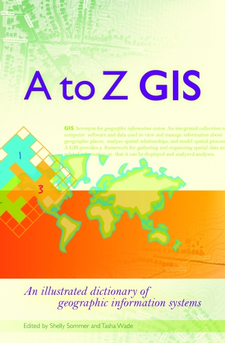
Book: A to Z GIS
A to Z GIS: An illustrated dictionary of geographic information systems, edited by Tasha Wade and Shelly Sommer (Redlands, California: ESRI Press, 2006), 268 pages.
With short, clear, and authoritative definitions of more than 1,800 terms written by more than 150 subject-matter experts, this small book is so useful it is addictive! Designed to be "a comprehensive technical dictionary for GIS students and professionals alike," according to the preface, the editors' goal was to "create definitions that are technically accurate yet not intimidating to the GIS novice." Nearly 400 beautiful color illustrations enhance the book's clarity and visual attractiveness.
An appendix supplements the main text with five encyclopedia-style articles: "Cartographic text in ArcGIS software: Annotation, labeling, and graphic text," by Craig Williams, ESRI product engineer; "Geometry: Creating map features with points, lines, and polygons," by Rob Burke, ESRI instructor; "How features and feature attributes are stored," by Burke; "An overview of layers in ArcGIS," by Jeff Shaner and Anthony Burgon, ESRI product engineers; "Projected and geographic coordinate systems: What is the difference?" by Melita Kennedy, ESRI product engineer; "Remote sensing," by Timothy Kearns, ESRI product engineer; and "The benefits of using topology in GIS," by Burke.
It will not surprise those who know my background that the very first term I looked up upon receiving the book was GPS: Acronym for Global Positioning System. A system of geosynchronous, radio-emitting and -receiving satellites used for determining positions on the earth. The orbiting satellites transmit signals that allow a GPS receiver anywhere on earth to calculate its own location through triangulation. Developed and operated by the U.S. Department of Defense, the system is used in navigation, mapping, surveying, and other applications in which precise positioning is necessary. See also GLONASS.
Unfortunately, I was very disappointed to find a few errors in this short paragraph. Never mind that, as a picky editor, I objected to the very first word, because only abbreviations that can be pronounced as a word—such as BLOB (for binary large object) or CAD (for computer-aided design)—are acronyms. More substantively, GPS satellites are not geosynchronous—a term that happens to be defined on the opposite page from the GPS entry, as follows: "Positioned in an orbit moving west to east with an orbital period equal to the earth's rotational period." GPS satellites circle Earth in 11 hours and 58 minutes, not 24 hours. GPS is used not for determining positions only "on the earth," but "on or near the earth" (aircraft use GPS). GPS does not rely on triangulation (the way, say, an RDF does) but on trilateration. Different physics, geometry, and math.
These errors made me wonder about the accuracy of the entries for subjects with which I am less familiar.
Briefly Noted
I have come across many incorrect references to GPS, GIS, and related technologies in the popular press over the years. (One of the most common: Global Positioning Satellite.) However, this mishmash, from an article in the New York Times takes the cake: "global imaging system maps made with aerial photographs"!!
Department of Corrections
My article, last week, about eRide, contained a few errors. First, eRide and Furuno are not "jointly developing" a GPS receiver; rather, Furuno is a licensee and partner of eRide. Second, the GPS receiver in question, while contained in a single package, is multi-chip, not single-chip. Third, Furuno will start worldwide distribution of eRide products, not just of this GPS receiver. Fourth, "In addition to conventional static GPS positioning" should have been "In addition to autonomous (as opposed to assisted) GPS positioning." Fifth, at Trimble Labs Paul McBurney worked with a team of engineers, but did not manage it. I regret these errors and will replace the version of this article in our archive with a new one that incorporates these corrections and a few additional ones.
News Briefs
Please note: I have culled the following news items from press releases and have not independently verified them.
-
CONTRACTS & COLLABORATIONS
-
Valtus Imagery Services and I.S.M. International Systemap Corp. have formed a strategic partnership in Web-based stereo-image delivery, either as downloadable data products or used on-line in GIS desktop applications. GIS is fast becoming the final destination of ortho-rectified imagery and Web-delivery the method of choice. Easy interoperability improves efficiency and the overall user experience for all end-users, from civic governments to earth resource scientists. Valtus' open GIS protocols already support instant viewing of high-resolution ortho-rectified imagery via a wide range of industry-standard Web-mapping products and desktop applications.
Through this new partnership, Valtus now expands its product offerings to include geo-referenced stereo-imagery, viewable via I.S.M.'s PurVIEW plug-in, first available for ArcGIS. The partners will exhibit the first phase of available products at the ESRI Canada Regional User Conference in Toronto today.
-
North West Geomatics Ltd. has announced detailed plans to create a new digital elevation model (DEM) for the province of Alberta, Canada. Commencing in the spring of 2007, North West will utilize the latest LiDAR and airborne, dual frequency synthetic aperture radar (SAR) technologies to accomplish this task. Current plans will see the heavily forested and rugged foothill areas of the province being covered with high accuracy LiDAR data. Acquisition and processing procedures will result in a highly accurate bare Earth and full feature dataset for the entire region.
These plans will see in excess of 100,000 square kilometers of area being covered with LiDAR. North West has extensive experience in this technology and over the past three years has accumulated the largest proprietary LiDAR database in Canada. Current holdings are in excess of 50,000 square kilometers in NE British Columbia and Alberta, nearly three times the holdings of any competing database.
The balance of the plains areas of Alberta will be acquired using the latest in dual frequency IFSAR data in partnership with North West's partner, EarthData International. The GEOSAR system employs a proprietary dual frequency interferometric approach to obtain ground accuracies far superior to any existing airborne or satellite SAR system. The GEOSAR system collects an extremely large swath with each flight line, which is essential in collecting the entire plains areas of Alberta in a timely and accurate manner. The GEOSAR areas will be augmented with strategic LiDAR data to ground truth and provide the highest possible accuracy with this technology.
In anticipation of this plan, North West conducted a pilot survey using GEOSAR to provide digital elevation data over one of North West's proprietary LiDAR areas near Grand Cache, Alberta. A detailed analysis was performed comparing the ground and forest cover data determined from GEOSAR to the LiDAR data. Recent developments in this dual frequency technology have confirmed a reliable RMSE accuracy of 1 meter in both forested and unforested areas.
North West is currently in partnership discussions with select key industry companies to provide additional resources to the program.
The entire dataset will be collected over a two-year period, with priority regions established jointly between North West and its clients. Opportunity exists for initial partners in the program to gain access to the entire data DEM database through up-front investment at a preferential cost.
-
Infotech Enterprises America, Inc., formerly known as VARGIS, LLC, has completed a project for the City of Helena, Montana, within 120 days from award. In June of this year, the City, through a competitive bid process, selected Infotech for digital orthophotography and planimetric data services. The City and Lewis and Clark County share a combined GIS that partially includes AutoCAD drawings, ArcGIS databases, and aerial imagery.
The overall objective for this project was to provide the most up-to-date base-map product to be used in the City's GIS. The system will be populated with spatial data products and digital orthophotography. The project encompassed the entire metropolitan area, which involved updates to all aerial imagery as well as updated continuous contours, building footprints, and transportation features where changes have not occurred since 2001. All updates will support the city and county governments.
-
MultiVision USA, a provider of high-resolution oblique imagery and 3D viewing software, recently delivered oblique aerial photography to Pasco County, Florida. The county will use the imagery and viewing software for property appraisal, public safety, and other local government activities.
MultiVision USA uses an advanced aerial imaging system to acquire high-resolution oblique imagery for use in property appraisal, assessment, and other applications that benefit from multi-perspective and 3D viewing capabilities. With the photography completed, Pasco County now owns high-resolution 3D imagery for approximately 300 square miles of territory, covering the most highly populated areas of the county, which incorporates 750 square miles.
Mike Wells, Pasco County's Property Appraiser, said his staff of 72 people will use the system to find improvements made to houses and buildings without permits that may affect their property values. In addition, the new imagery will be put to use by the School Board, County Commissioners, and Public Safety Department.
The license purchased by Pasco County allows use of the system by all county government agencies. Two cities within the county have also received copies of the MultiVision 3D viewing software. Dade City will use the system to identify areas to focus on for restoration and historic preservation regulations. The City of New Port Richey will likely use it to find un-permitted building work and for public safety purposes. The local school board intends to use the system for inventory management.
MultiVision software integrates oblique and ortho aerial photos into a single database and provides onscreen tools to measure vertical and horizontal structures, such as building facades, backyard patios, and terrain features from any angle or direction. The tools are used in a variety of applications, from property assessment to civil planning. The software works directly with all GIS-based applications, allowing for the importing and exporting of additional data layers without third-party software.
-
-
PRODUCTS
-
QCoherent Software, provider of Limitless LIDAR software tools, has released LP360 version 1.3, the LIDAR extension for ArcGIS. LP360 employs a specially designed ArcMap data layer to access and draw LIDAR points directly from LAS files. The product supports large quantities of point cloud data and facilitates the integration of LIDAR data with other GIS data types supported by ArcGIS. New to version 1.3 is cross-section exporting, an embedded 3D viewer, and GIS fusion technology.
-
Aerials Express has re-flown the Little Rock area for 2006 and is set to deliver the industry's newest imagery. The company's AEView GIS software, free with the purchase of its current high resolution aerial imagery, includes parcel, transportation, elevation, flood, and point of interest data to enable users to conduct location analysis, perform engineering applications, and create poster-sized presentations. Those who do not need the functionality of a full-fledged GIS may be interested in ViewGL for Google Earth.
-
Red Hen Systems, Inc. has released IsWhere for Google Earth, a simple utility that displays where GPS-tagged photos were taken. IsWhere works with any image that has Global Positioning System (GPS) data stored in its EXIF header. This new utility provides a method for photographers and photo analysts to quickly verify and communicate the spatial location of photos. With a right mouse click or drag-and-drop selection, users pass images to IsWhere to quickly display them and their locations inside the Windows version of Google Earth.
Whether you are documenting an accident scene, comparing potential building sites, or monitoring a right-of-way, IsWhere enables you to easily see where each photo was taken. Save the photos in your favorite places or email them to others for them to map and view. IsWhere makes it easy to SNAP, MAP, and SHARE your world.
Creating a Red Hen Photo that has GPS information embedded with the digital photo can be done in several ways. GPS data can be written to the photo at the time of collection with different integrated camera/GPS solutions—such as the Nikon digital SLR cameras (D1X, D1H, D2Xs, D2X, D2H and D200) with Red Hen's DX-GPS, or with the Ricoh Caplio Pro G3 GPS-ready digital camera. Alternately, using only a GPS receiver and a digital still camera, images can be matched with a GPS log file using Red Hen's patented time-matching methodology, available in two packages:
- PixPoint for ESRI's ArcGIS software, and
- MediaMapper
IsWhere is a free download when you buy either the Red Hen DX-GPS for a Nikon camera or the Ricoh Caplio G3 from Red Hen. Separately, IsWhere retails for $29.95.
-
ESRI has released a new version of ArcPad and ArcPad Application Builder, ESRI's software for mobile GIS and field mapping applications. At 7.0.1, ArcPad products address issues raised from previous releases and feature significant improvements that users have been anticipating, mainly in the areas of performance and usability.
ArcPad provides field-based personnel with the ability to capture, store, update, manipulate, analyze, and display geographic information. This allows them to perform reliable, accurate, and validated field data collection. Users can also incorporate data input from GPS receivers, range finders, and digital cameras in the data collection process.
Highlights of ArcPad at this release include
- Significantly faster loading time on devices—Load speed improvements of 25-50 percent have been observed on various devices.
- Faster drawing of features—Features with and without labeling draw significantly faster, particularly noticeable with large datasets.
- A custom datum configuration tool—This tool assists users in defining new datum transformations and selecting default transformations.
- Support of multiple lines in label expression fields—A vertical scrollbar can be used to view the text.
- ArcGIS 9.2 support—The default style sheet and projection files have been updated to match those in ArcGIS 9.2.
- Enhanced localization—Korean and Czech language packs have been added.
The development framework for building custom ArcPad applications for mobile GIS, called ArcPad Application Builder, is sold separately and has also been updated. More samples are available in the help file including a datum transform sample and a camera extension sample. In addition, the object model has been updated with new constants and a new Click Action property for the IMAGEBOX control.
To evaluate ArcPad 7.0.1, visit www.esri.com/arcpad. Existing ArcPad users can upgrade to ArcPad 7.0.1 for free by downloading the evaluation file. The ArcPad Application Builder 7.0.1 update will be shipped automatically to customers who are current on maintenance without additional cost.
-
-
CONFERENCES
-
A senior Battelle official with broad responsibilities for fostering technology transfer in the Pacific Northwest—including serving as science/technology advisor to Oregon governor Ted Kulongoski—will be the keynote speaker for the Government Open Source Conference, which gets underway today. Erik Stenehjem, Ph.D., a senior staff member at Battelle's Pacific Northwest National Laboratory (PNNL), will discuss open source technology as a "world flattener," borrowing from the 2005 best seller, The World is Flat: A Brief History of the 21st Century, by Thomas Friedman. The talk is set for 8 a.m. at the Governor Hotel, in downtown Portland.
Stenehjem's background includes launching and overseeing a variety of venture-backed businesses built around technologies developed at the PNNL, including two currently with products in national and international markets. In partnership with the research institutions of the Northwest region, Stenehjem and his staff helped to develop a program to find and "bundle" similar or complementary technologies from major research institutions in Oregon, Washington, and Idaho and apply these same methods to finding knowledge-based clusters of economic activity within the region.
Stenehjem was a recipient of the Federal Laboratory Consortium award for excellence in technology commercialization in 2005. Other GOSCON featured speakers include:
- Bill Welty, CIO for the State of California Air Resources Board and former information officer for the California Environmental Protection Agency
- Andy Stein, director of Information Technology for the City of Newport News, Virginia, a leading local proponent of open source technologies for the public sector
- Ward Cunningham, creator of the "wiki" Web pages and a director of the Eclipse Foundation
- Sher Shah Farooq, security expert (OSRC), Pakistan Ministry of Information Technology and Telecommunications
- John Scott, director of Open Integration for Radient Blue Technologies and a principal author of the Open Technology Development Road Map developed recently at the U.S. Department of Defense
- Brad Wheeler, chief information officer for Indiana University and a leading academic proponent of open source technologies.
The depth of the program plus the growing awareness of open source products has dramatically increased interest in GOSCON and registrations for the two-day conference are quadruple what they were at this point for last year's event, with attendees coming from literally around the world. GOSCON has also garnered additional support from such technology companies as IBM, Novell, Red Hat, SugarCRM and Cignex.
Last year's debut GOSCON conference drew hundreds of participants and focused new attention on the unique challenges and opportunities of open source technology in government information technology environments. Oregon State University, organizer of the conference, is a recognized leader in open source software among public institutions. Its Open Source Lab hosts some of the world's most popular open source projects, including the Mozilla Firefox browser and the Linux kernel - the heart of the Linux operating system.
-
URISA's Annual Conference in Vancouver, BC was one of the best-attended and most favorably reviewed URISA conferences in years. More than 700 people attended the conference, which included twelve pre-conference workshops, two keynote speakers, seventy sessions, and more than 200 presenters. There was even a 'conference within a conference,' with URISA's 2006 Public Participation GIS (PPGIS) Conference running concurrently with the regular conference sessions. The networking and social events were enjoyable and re-instilled the sense of camaraderie for which URISA is known.
The Professional Development track (new this year) was a huge success with sessions ranging from "How to Influence Decision-Makers" to the interactive panel discussion "Career Coaching: What you can learn from successful GIS professionals." The first-time attendee orientation meeting and the speed networking session served to strengthen URISA's commitment to new/young professionals in the field.
URISA was honored to have so many URISA Past Presidents and former Board members in attendance; and URISA GIS Hall of Fame recipients Gary Hunter (2006), Jack Dangermond (2005) and Nancy Tosta (2005) all effectively communicated the importance of URISA in their very esteemed careers. Vancouver was the ideal host city with a never-ending list of attractions and beautiful weather.
Attendees thanked four Board members for their amazing contributions to URISA during their terms of service on the Board of Directors: Dianne Haley, Kathrine Cargo, Steve Kinzy, and Lisa Lubeley. Cindy Domenico passed the URISA President's gavel on to Ed Wells, who will be the URISA President until the close of the organization's 2007 annual conference. The Board welcomed Susan Johnson (President-Elect), Al Butler, Juna Papajorgji, and Geney Terry to their new positions on the Board.
URISA's 45th Annual Conference will take place 2007 August 20-23, in Washington, DC.
-
-
PEOPLE
-
To address the increasing demand for geospatial solutions, Infotech, formerly known as VARGIS, LLC, has hired a new senior account manager, Clark Selby. He has more than 15 years of experience, including eight years directly involved in photogrammetry and GIS services.
Selby plans to focus on national accounts in the commercial sector and local, state, and federal accounts in the government sector. Prior to joining Infotech, he was the Regional Manager at BAE Systems.
-
During URISA's 44th Annual Conference, in Vancouver, last month, several of the association's leaders received special awards.
The URISA Leadership Award is presented to members who have demonstrated exemplary leadership to URISA, creativity, innovation, and dedicated support of URISA programs. This year's Leadership Award was presented to all of the URISA 2006 annual and specialty conference chairs:
- Integrating GIS & CAMA Conference, February 19-22, Orlando, Florida, Conference Chair: Cindy Braddock, Boulder County Assessor's Office, Boulder, Colorado
- Geospatial Integration for Public Safety Conference, April 10-12, Nashville, Tennessee, Conference Chair: Mike Walls, Atos Origin, Lexington, Kentucky
- URISA 2006 Annual Conference, September 26-29, Vancouver, British Columbia, Conference Chair: Sandi Majewski, Las Vegas Metro Police Department, Nevada
- URISA's 2006 Public Participation GIS Conference, September 27-28, Vancouver, British Columbia, Conference Chair: Melinda Laituri, Colorado State University, Fort Collins, Colorado
- URISA's 2006 Caribbean GIS Conference, October 30-November 2, Nassau, Bahamas, Conference Chair: Carolann Albury, Bahamas National GIS Centre, Nassau Bahamas
The URISA Service Award is presented to members who have demonstrated faithful service to URISA and have participated in its programs over a period of several years. The award is for service in a number of programs or committees, and a willingness to take on challenges without regard to the potential for recognition. Juna Goda Papajorgji is the recipient of the 2006 URISA Service Award.
She divides her professional life between Alachua County, Florida where she has been instrumental in establishing the first GIS Division under the Board of County Commissioners, and the University of Florida, where she teaches GIS each semester and conducts research. She worked for eleven years at the National Academy of Sciences in Tirana, Albania prior to being introduced, in the United States, to GIS, to which she has dedicated the last twelve years. Papajorgji was instrumental in establishing URISA's GISCorps and continues to lead its strategic growth. She was also instrumental in establishing a partnership between URISA and the GSDI association in their joint annual Small Grants Program. For the last three years she has also served as the Director of the Gatorland Region for the Florida Chapter of URISA and she has served on the National Outreach Committee of the GIS Certification Institute. During 2007-2010, she will serve on the Board of Directors of URISA.
The 2006 Barbara Hirsch Special Service Award was awarded to Eric Bohard, GISP and the Website Task Force. Over the past year, a group of URISA members has been working with URISA staff to design and launch a new website. Eric Bohard took on the responsibility of supervising the project and worked with one of his staff members, Dan Zeazas, to set up the Web server. Tom Kimpel, Tim Case, Gurdeep Singh, Marc Forgang and Michael Tasker were also instrumental in leading this effort.
-
Peter L. Croswel, GISP, with a long and distinguished record of leadership and contribution to URISA and the GIS community, was the recent recipient of URISA's prestigious Horwood Distinguished Service Award during the association's 44th Annual Conference in Vancouver, British Columbia. This award is URISA's ultimate award for service and leadership to URISA and the geospatial industry.
Since 1985, as a consultant with PlanGraphics, Croswell has managed or been a major participant in more than 150 GIS and AM/FM planning, design, and implementation projects for federal agencies, state and local governments, regional organizations, utility companies, and private firms in North America, Europe, China, and the Middle East. He has actively participated in research and educational endeavors on national and international GIS and IT standards and their impact on spatial data infrastructures. This includes his work with the URISA Standards Committee, the Federal Geographic Data Committee, and the NAS Mapping Sciences Committee.
Prior to joining PlanGraphics, Croswell participated in the development and then served as manager of the Kentucky Natural Resources Information System (KNRIS) with the state of Kentucky Natural Resources and Environmental Protection Cabinet (KNREPC) and was the Administrator of the Cabinet's Lands Unsuitable for Mining Program. He also served as a Cartographer for the New York State Sea Grant Institute.
Croswell received a master's degree in geography and geology from Western Illinois University and a bachelor's degree in geography and mathematics from the State University of New York at Albany where he graduated magna cum laude and was inducted into Phi Beta Kappa.
Croswell is active in professional associations and participates through paper presentations and educational symposia sponsored by URISA, ASPRS, and other organizations. He has served on the Board of Directors of URISA (1992-1995 and 1996-1999), chaired its Standards Committee (1989-1991), and served as URISA President in 1998. He was also a recipient of URISA's Horwood Best Paper Award (1990) and Leadership Award (2000). He is a Certified GIS Professional (GISP), Professional Project Manager (PMI Institute), a Certified Emergency Number Professional (NENA), an ASPRS Certified Mapping Scientist, and a recipient of ASPRS's President's Award for Practical Papers (1990).
Croswell is co-author of: Geographic Information Systems: A Guide to the Technology, a GIS reference book originally published in 1991 by Van Nostrand Reinhold and the Chief Editor of the 1998 URISA Publication, Spatial Information Technology Standards and System Integration. He is also a contributing author to Profiting from a Geographic Information System, published in 1993 by GIS World, Inc., and GeoSpatial Data Infrastructure: Concepts, Cases, and Good Practice (Oxford University Press, 2000).
Croswell has been a URISA member since 1980; has attended all annual conferences since 1982 and many chapter events around the United States. He has served on the conference committee for four annual conferences; has made paper presentations at 16 conferences; and serves frequently as a session moderator. In addition, he was an Industry Relations Committee Member and Chair 1992-2004.
Since 1986, Croswell has actively been involved with URISA workshops, including the development of three different workshops and has instructed workshops at over 30 national and regional events. The Horwood Award is further recognition of his contributions and stature in the community of GIS professionals and academicians.
Horwood Distinguished Service Award History:
- 1975 Edgar Horwood
- 1979 Will Steger
- 1980 Bob Aageenbrug
- 1985 Barry Wellar
- 1988 Jack Dangermond
- 1991 David Moyer
- 1993 William Craig
- 1994 Constance Blackmon
- 1995 William DeGroff
- 1996 Ben Niemann
- 1997 Ken Dueker
- 1999 William Huxhold
- 2001 Ed Crane
- 2002 Mike Kevany
- 2004 Donald Cooke
- 2005 Lyna Wiggins
-
-
OTHER
-
IDELIX Software Inc. has launched IDELIX Labs, a new website that showcases some of the technologies and products under development by the IDELIX team and by IDELIX partners. The website features beta releases of PDT-enabled products. Pliable Display Technology (PDT) by IDELIX is a visualization tool that facilitates and simplifies viewing and interaction with complex digital information. The site was launched with three new "Look" family products: LookOUT, LookLOCAL, and LookWMS.
LookOUT is a new add-in for Microsoft Outlook that enables users to quickly map search locations and directions from within Outlook. LookOUT differs from other map connectors by taking a contact-centric approach, and leveraging the intuitive UI and quick comparison capabilities of LookLOCAL.
LookLOCAL is an online mapping site where visitors can use a PDT lens to explore and interact with data from Google Maps, Yahoo! Local Maps, and Windows Live Local. This latest beta release of IDELIX's online mapping site features major improvements to the user experience.
LookWMS is a new WMS Web map client that allows access and interaction with geospatial data accessed over the Internet from Web Map Servers that implement OpenGIS specifications. There are several unique WMS client features in LookWMS designed to increase efficiency and usability. The PDT lens and transparency have been included to enable rapid comparison of data layers. For mobile workers, the LookWMS client also provides the ability to take data at multiple resolutions on the road when a network connection is not available.
-
Advertise with Us
You can reach more than 23,000 GIS professionals every issue by sponsoring GIS Monitor. For more information, email us.
Contact
Please send comments and suggestions to:
Matteo Luccio, Editor
GIS Monitor
Ultimate Map/GIS Directory — Your search is over!
GIS Monitor is published by:
GITC America, Inc.
100 Tuscanny Drive, Suite B-1
Frederick, MD 21702 USA
Tel: +1 (301) 682-6101
Fax: + 1 (301) 682-6105
Subscribe/Unsubscribe
If you wish to subscribe or unsubscribe visit our subscription page.