

2006 October 12
This issue sponsored by
ESRI
Contents
- Editor's Introduction
- Visual Learning Systems Ships LiDAR Analyst 4.1
- Book: A to Z GIS
- Briefly Noted
- Department of Corrections
Departments
If, for some reason, you cannot read this document, please visit:
http://www.gismonitor.com/news/newsletter/archive/archives.php?issue=20061012
Editor's Introduction
This week I visited the offices of Visual Learning Systems (VLS) in Missoula, Montana, and interviewed the company's president. In this issue I also bring you a few other tidbits and my usual round-up of news items from press releases. Tomorrow I will be in Portland, Oregon, at the Government Open Source Conference 06; I will report on that conference in next week's issue.
— Matteo

Visual Learning Systems Ships LiDAR Analyst 4.1
Ten days ago, Visual Learning Systems (VLS) began shipping version 4.1 of its LIDAR Analyst automated feature extraction software for ArcGIS. According to the company, the product's new capabilities include the extraction of complex 3D roof geometry; faster and cleaner extractions of 3D buildings; enhanced bare earth extraction, modification, and DEM editing tools; revamped tree and forest region extraction workflow; the ability to read, classify, and write .LAS format point cloud files; smart 3D editing tools for buildings; the ability to edit and crop point cloud files; and automated attribution of features—such as height, area, perimeter, and crown width.
Yesterday, at VLS' offices in Missoula, Montana, I discussed the company's history, technology, and vision with its co-founder and president, Dr. David Opitz. Then Bill Veteto, a GIS analyst, demonstrated for me various capabilities of the company's products.
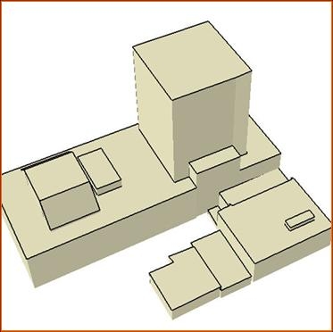
Extracted 3D shapefile
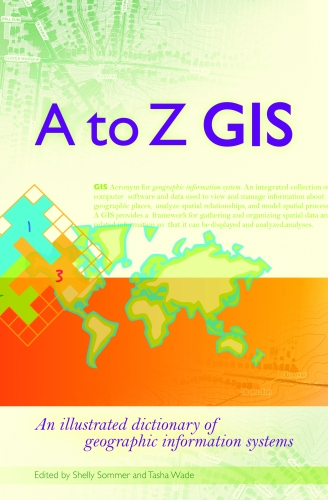
Book: A to Z GIS
A to Z GIS: An illustrated dictionary of geographic information systems, edited by Tasha Wade and Shelly Sommer (Redlands, California: ESRI Press, 2006), 268 pages.
With short, clear, and authoritative definitions of more than 1,800 terms written by more than 150 subject-matter experts, this small book is so useful it is addictive! Designed to be "a comprehensive technical dictionary for GIS students and professionals alike," according to the preface, the editors' goal was to "create definitions that are technically accurate yet not intimidating to the GIS novice." Nearly 400 beautiful color illustrations enhance the book's clarity and visual attractiveness.
Briefly Noted
I have come across many incorrect references to GPS, GIS, and related technologies in the popular press over the years. (One of the most common: Global Positioning Satellite.) However, this mishmash, from an article in the New York Times takes the cake: "global imaging system maps made with aerial photographs"!!
Department of Corrections
My article, last week, about eRide, contained a few errors. First, eRide and Furuno are not "jointly developing" a GPS receiver; rather, Furuno is a licensee and partner of eRide. Second, the GPS receiver in question, while contained in a single package, is multi-chip, not single-chip. Third, Furuno will start worldwide distribution of eRide products, not just of this GPS receiver. Fourth, "In addition to conventional static GPS positioning" should have been "In addition to autonomous (as opposed to assisted) GPS positioning." Fifth, at Trimble Labs Paul McBurney worked with a team of engineers, but did not manage it. I regret these errors and will replace the version of this article in our archive with a new one that incorporates these corrections and a few additional ones.
News Briefs
Please note: I have culled the following news items from press releases and have not independently verified them.
-
CONTRACTS & COLLABORATIONS
-
Valtus Imagery Services and I.S.M. International Systemap Corp. have formed a strategic partnership in Web-based stereo-image delivery, either as downloadable data products or used on-line in GIS desktop applications. Read more …
-
North West Geomatics Ltd. has announced detailed plans to create a new digital elevation model (DEM) for the province of Alberta, Canada. Read more …
-
Infotech Enterprises America, Inc., formerly known as VARGIS, LLC, has completed a project for the City of Helena, Montana, within 120 days from award. Read more …
-
MultiVision USA, a provider of high-resolution oblique imagery and 3D viewing software, recently delivered oblique aerial photography to Pasco County, Florida. Read more …
-
-
PRODUCTS
-
QCoherent Software, provider of Limitless LIDAR software tools, has released LP360 version 1.3, the LIDAR extension for ArcGIS. Read more …
-
Aerials Express has re-flown the Little Rock area for 2006 and is set to deliver the industry's newest imagery. Read more …
-
Red Hen Systems, Inc. has released IsWhere for Google Earth, a simple utility that displays where GPS-tagged photos were taken. Read more …
-
ESRI has released a new version of ArcPad and ArcPad Application Builder, ESRI's software for mobile GIS and field mapping applications. Read more …
-
-
CONFERENCES
-
A senior Battelle official with broad responsibilities for fostering technology transfer in the Pacific Northwest—including serving as science/technology advisor to Oregon governor Ted Kulongoski—will be the keynote speaker for the Government Open Source Conference, which gets underway today. Read more …
-
URISA's Annual Conference in Vancouver, BC was one of the best-attended and most favorably reviewed URISA conferences in years. Read more …
-
-
PEOPLE
-
To address the increasing demand for geospatial solutions, Infotech, formerly known as VARGIS, LLC, has hired a new senior account manager, Clark Selby. Read more …
-
During URISA's 44th Annual Conference, in Vancouver, last month, several of the association's leaders received special awards. Read more …
-
Peter L. Croswel, GISP, with a long and distinguished record of leadership and contribution to URISA and the GIS community, was the recent recipient of URISA's prestigious Horwood Distinguished Service Award during the association's 44th Annual Conference in Vancouver, British Columbia. Read more …
-
-
OTHER
-
IDELIX Software Inc. has launched IDELIX Labs, a new website that showcases some of the technologies and products under development by the IDELIX team and by IDELIX partners. Read more …
-
Advertise with Us
You can reach more than 23,000 GIS professionals every issue by sponsoring GIS Monitor. For more information, email us.
Contact
Please send comments and suggestions to:
Matteo Luccio, Editor
GIS Monitor
Ultimate Map/GIS Directory — Your search is over!
GIS Monitor is published by:
GITC America, Inc.
100 Tuscanny Drive, Suite B-1
Frederick, MD 21702 USA
Tel: +1 (301) 682-6101
Fax: + 1 (301) 682-6105
Subscribe/Unsubscribe
If you wish to subscribe or unsubscribe visit our subscription page.