Letters, Points of Interest, Week in Review (Announcements, Contracts, Products, Education, Events, Hires) Back Issues, Advertise, Contact, Subscribe/Unsubscribe If, for some reason you cannot read this document, visit: http://www.gismonitor.com/news/newsletter/archive/070303.php
NEW TECHNOLOGY IN TRANSLATION: AN INTERVIEW WITH SAFE SOFTWARE The latest version of FME, Safe's core product, is called FME 2003 X2. Not surprisingly, it adds six new formats to the current list of more than 100 supported formats, updates several formats, and includes many enhancements. "A key focus, however, was simplifying the user experience," says Murray. "We lowered the bar for users." Although the product supports two separate user interfaces (the Universal Translator and Workbench), the key part of the simplification has been expanding the product's Workbench interface, which is a tool that "maps out" a complex (or simple) set of operations to be performed as a batch process. Before Workbench, these operations had to be expressed in a rule script called an FME mapping file. "When Workbench was formally introduced two years ago," Lutz explained, "about 80% of FME's functionality was available through Workbench. "Now," he reports, "Workbench is the way to access all of FME's functionality. In fact, there are things you can now do with a few clicks in Workbench that you'd likely not even want to attempt in a mapping file."
Workbench is playing another important role for users: documenting workflow. Once Safe learned the importance of printing poster-sized "maps" of FME workflows, that layout and printing became a key area for enhancement. The interest in these "maps" reminds me of how ESRI recently described users working with posters of data models. Safe typically chooses to support new data formats based on customer demand. One very new service, Web Feature Service (WFS), an OpenGIS Specification for delivering vector features in Geography Markup Language (GML), is currently supported for use even though the pair agrees, there are still few WFS servers to "plug into." Murray envisions that in time, as more WFSs pop up, Safe's FME (at the client side) or SpatialDirect (on the server side) will be the tools of choice to turn GML into the required format for use. (GML is an encoding, a way of moving data, but it's not really designed for "doing" GIS.) Safe has seen significant demand for support of open source spatial database offerings including PostGIS built on PostgreSQL and MySQL's upcoming spatial implementation. This demand comes from an assortment of clients and regions, including local governments, forestry users, some commercial vendors and many foreign GIS users. Lutz explains that one of the concerns often expressed in North America about open source implementations is paying for consulting to get the products up and running. That, he points out, is far less of an issue in developing nations, where consulting and other labor costs are quite low. Safe is pleased that many of these open source users are happy to pay Safe for translation tools and connectors to commercial software. Murray adds that developing countries are particularly active in this area because they need/want GIS, but rarely have the money for powerful database solutions. He also sees a place for open source databases as embedded solutions, providing a spatial option for what Access often provides in the non-spatial arena. (Access is used as the basis for ESRI's personal geodatabase. However, unlike Oracle, it does not natively support spatial data. Intergraph users use Access and SQL*Server in a similar way.) I asked about the implications of Safe (and perhaps other's) tools for linking open source and commercial data storage solutions on the GIS landscape. "The quilt - with many different pieces sewn together - is coming," both agree. And, that pleases them since they feel that it's in customers' best interests to pick and choose the best components to build their solutions. The most popular combination that Safe currently sees involves customers who want to put a commercial Internet Map Server in front of an open source spatial database. A new challenge for the programmers at Safe is dealing with large raw data volumes. While Safe has always had clients with large datasets, current demands from government and industry are escalating. For example, reports Lutz, some clients are looking to operate on as many as 31 million features at a time to weed out duplicates during a single translation run. While Safe's code has always been efficient (it had to be: it was originally written to run under memory-limited DOS computers), simply randomly accessing that many features at one time is a challenge, even with today's advanced hardware and operating systems. Those same users also need replication, but not necessarily the standard type of replication supported in enterprise level databases. That type of replication can replicate tables, that is, make an exact duplicate in a specified location based on a trigger (an event). That's one of the draws of something like Oracle for geospatial users - the tables can be replicated for enhanced performance or security. But, what if you need to replicate data to another table that doesn't have the same structure (schema) as the first? Safe can do that. "It's a matter," says Don, "of putting that 'T' for transformation into the replication picture." He described a customer who, using triggers, needed to replicate a database with 1200 tables, to a second one, with a different structure built on 250 tables. (If you are keeping score, that's along the lines of what Kurt Buehler described in the data model discussion a few weeks ago as part of semantic interoperability.) To wrap up I asked the pair about Bentley's commitment to support the OpenDWG Alliance in providing libraries to read and write DGN V8. Lutz explained that it makes Safe's developers' job easier. More importantly, it means that Safe customers who have been waiting for Safe to support the new format can finally move to MicroStation V8. Says Murray, "It's a good thing for all of us."

NEW TECHNOLOGY IN OBLIQUE IMAGING: OBLIVISION
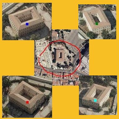
The system, called Oblivision, is from Idan Computers Ltd., based in Israel. The solution combines ordinary orthophotos and digital terrain models with oblique images. Once a spot is selected (by clicking on the orthophoto, supplying coordinates, an address etc), the system provides views of the spot from all directions. Analysis and measuring can be done on the individual oblique photos. Heights of poles can be measured, or the length of a guard rail, for example.
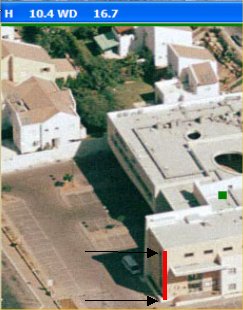
The distinguishing characteristic of this system? There is no need to know the camera position while acquiring the oblique images. Moreover, any camera can be used, from consumer grade on up. Oblivision clients include the Israeli police, army, municipalities, and architects. While much of the system's use in Israel focuses on security, the company website notes that the system has been used in highway construction projects to check for changes over time, and in mining activities to keep an inventory. In these situations new oblique photos are taken at regular intervals, every few days or weeks, as needed. The imagery is highly compressed so that images covering an area can be cut to a CD to be carried in a vehicle or by a soldier on foot. I asked Joseph Freund, Idan's CEO how the system works. "Basically, what we are doing is 'solving' each oblique photo in a very simple way," he explained. "We need to identify four points both in the oblique and in the orthophoto. (The same four points.) For each oblique photo we have then an 'OBL' file, a sort of 3D world file. The first two columns are pixels in the oblique photo and the last 3 are the X,Y,Z world coordinates in the orthophoto." The next step involves the digital terrain model (DTM), typically the same one used to create the orthophoto. (Recall that an orthophoto is basically a photo with the "lumpiness" of the earth subtracted out. The DTM describes "what to subtract out.") Freund explained that using the DTM, "this OBL is then 'solved' to create a JFR file, that includes the transformation matrix for the image. As a byproduct, we get the exact location of the camera. After that, we can click a point in the oblique photo and show it on the orthophoto, and vice versa. And, we can do horizontal and vertical measurements in the oblique photos." In practice, clients collect their own oblique photos and provide the coordinate pairs to Idan. Idan staff constructs the JFR files and returns them to the client, who can then use the images with the Oblivision software. Some clients license the solution module so they can create their own JFR files, but most use Idan as a service bureau to create the required files.
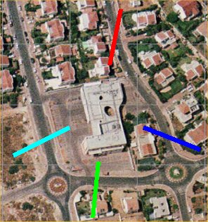
The client software used to access and analyze the imagery is impressive. One tool I found interesting draws the direction from which the oblique image was taken on the orthophoto. The line colors match the "dot" colors in the images (as in the image above). Another clever tool outlines the area covered by each oblique on the orthophoto, essentially "mapping out" the coverage area. I would imagine that's useful for determining if the appropriate amount of coverage is available for particular areas of interest. The image at left is the "Zofnat Paaneah" school in Jerusalem, built at the beginning of the 20th century. My sense is that demand for this sort of tool will only increase, so it's valuable to keep an eye on the different technologies that make it possible.

MORE ON GEOSPATIAL ONE-STOP State and local governments were credited with pushing the open architecture requirement. "Although the portal is only a first step, [Administrator of E-Government and Information Technology at OMB Mark] Forman praised the initiative for the work that's been done and stressed the benefits of moving to more open, standards-based architectures that state and local governments are demanding." What's ahead? "Work on a second iteration of the portal with enhanced functionality and alignment with the Federal Enterprise Architecture is already underway." In a very odd coincidence, just as the Geospatial One-Stop Portal was launched, the Department of Interior was being told to disconnect from the Internet. The issue is security, just as it was last December. The Department of Justice argues that over $1 billion in Indian funds are at risk.

MORE ON SHELBY COUNTY, INDIANA Several readers asked questions about details and other matters I could not answer. So, I contacted someone knowledgeable about the situation, Professor David A. Schoen of Ball State University, who was cited in the article as developing, with his students, a GIS for Shelby County and the City of Shelbyville. He was kind enough to take on these issues in some detail. The questions, trimmed down in the list below, but available in detail here, included: 1) What software was $245? 2) [Based on the understanding one "bid" was from a university.] "[The article suggests]�one state supported university in Indiana (Ball State) successfully expropriated work from another state supported university (Indiana University Purdue University Indianapolis). When does higher education cross the line from providing education and research to providing commercial GIS consulting and data conversion services that are in competition with the private sector? Should a university compete with the private sector using a business infrastructure (phones, email, internet, office space, utilities) that is supported by taxes, part of which are paid by the same companies with which it competes?" 3)[Based on stated pricing in the article of $8,000 for software and $29,000 for enhancements from one organization to $245 for software and $18,000 for enhancements from the other.] Both software and services differ substantially between the proposals, right?Schoen replies: "Point 1: Is the software Manifold? Yup! � This software delivers a lot of horsepower for the money and the only package (that I know of) that includes an Internet map server component without additional cost. Shelby County is actually using another software product for supporting their on-going GIS activities (GeoMedia) but I think the extremely low cost of using Manifold software, as an Internet map server, was intriguing to them. "Point 2. There seem to be two primary issues here: 1) why the difference in prices and 2) the issue of universities in the workplace. A third issue is the assumption that one university successfully expropriated the work of another university. "Let's start with the easy one. A careful reading of the original news article confirms that it was never mentioned that a 'university' won the contract. It didn't! The project was awarded to me as an individual, through my efforts as a consultant. I have done summer time consulting, on many different types of projects, for many years. I also feel that the use of the word 'expropriated' is inappropriate. To 'expropriate' is to 'remove one's property or rights' (paraphrased from Webster). Clients, and projects, should not be viewed as 'property' by any organization. "Lets move to the cost difference. Frankly, I don't know why there is a difference (excluding software cost, of course), as I was not privy to seeing any 'bid' except the one I submitted. Possible reasons include 'overhead rate,' cost of labor assigned to the tasks or if the bidder felt that purchase of expendable, or non-expendable, resources was required. There is also the issue of estimating how much time will be required to carry out a workflow - and that may depend on what human resources are available and what experience they bring to the table. I'm sure there are many other, more exotic, reasons why one potential vendor would bid quite different prices than other firms. "I have been associated with a truly fine university for almost 25 years. For those same years I have taught in a college that has provided nationally, and internationally, recognized community outreach programs to the public sector. We get numerous requests from individuals, public and private groups and local and state governments for assistance with projects. We weigh each potential project from primarily an educational perspective - but also many other criteria. I, and other faculty I am closely associated with in my College do not actively market these services! "The news article did mention that I, with my students, had created the GIS for Shelby County. It was a project that we decided had much merit from an educational perspective and was 'do-able' over a time frame that extended beyond a one-semester session. I believe we accomplished the project in just under two years and involved over 40 students (undergraduate and graduate). The experience they gained was enormous - from simple digitizing, database design and workflow design based on a needs approach to team management issues. Some of these students have now worked with firms that engage in GIS services on a routine basis. They were hired because of their experience with the project. One comment I later received from a principal of such a firm was that he was delighted that the new employee immediately was up and running, and more importantly, his firm didn't have to bear six months of salary while the employee went through expensive 'on the job training' training to make them productive. His last comment to me was 'send me more like that!' "We must all remember that universities are publicly supported - but only partially. Class fees, endowments, grants and other miscellaneous sources heavily contribute to a university budget. Along with this support comes responsibility - a responsibility not only to provide a world-class education, but also serve as a technical and professional resource. Many university faculty members participate on off-campus committees or panels at the request of government agencies. This type of responsibility is usually not borne by private industry. "I have heard on numerous occasions, from elected officials, that because a university is state-supported, it is a resource that they should be able to 'tap into.' I, and many of my colleagues, believe them to be correct. Where, or when then, does a university 'cross the line?' I don't know how anyone could define such a 'line!' "One of the issues raised was the issue of competition with private enterprise - especially with tax support for facilities (infrastructure). I do not believe this to be a valid argument because while universities are partially tax supported, they typically pass on any project overhead costs to the project's funding source, including faculty salary. I believe that the only basis that one could measure any advantage that a university would have over private enterprise is the cost of student employment. However, one must also weigh the fact that it is student employment! Workflows take longer to achieve because there is an educational component, and there is always the issue that it may have been done better by an experienced professional. An aggressive firm could certainly use this issue to their competitive advantage! "In summary, I believe that partnership projects between local government (and other groups as well) and universities are a good thing. It brings to the student an experience that will enhance their marketability and also benefit the firm hiring them. Such projects also return to the public a product as a result of a responsibility indirectly assigned to the university because it is publicly supported. We can ultimately define this product as 'value added.' 'Value added,' in some respects, is the measurement of positive trade-offs in a system that has a multitude of inputs and outputs and controlling mechanisms."

MORE ON THE TECHNOLOGY BEHIND THE NATIONAL MAP "You state: 'The viewer offered from GeoData.gov is not the same as the original or latest Map Viewer available on the National Map website. The National Map website, by the way, also depends on ESRI technology.' "We actually have four viewers linked on the National Map webpage you cite. The first listed (The National Map Viewer) uses no ESRI technology, except when calling the OGC WMS [Open GIS Consortium Web Map Service] connectors on ARCIMS servers (which in my mind means no dependence). A catalog of OGC WMS servers is used to provide access to what is viewed. The catalog is essentially how we want to define and implement The National Map (and will incorporate other OGC services as they become available). We see this viewer as a demonstration of how anyone's viewer (including a GeoData.gov portal of the future) can access The National Map. (I hope we can work with ESRI to convert what is now in the GeoData.gov portal as The National Map into a use of our catalog.) "The second viewer listed (Original The National Map Viewer) depends (I think) on ESRI technology only in that it talks directly to ARCIMS servers and takes advantage of that. This viewer has been superceded by the OGC WMS viewer, except for the download function. "Only the last two viewers (our production "Seamless Data Distribution I followed up to ask about the technology behind those implementations, and learned there is no "server" per se. A member of the technical team explained: "�the underlying technology is that the Catalog uses Oracle with Oracle Spatial and the Viewer connects to the Catalog through an HTTP interface. This service will eventually be exposed as a public interface to The National Map Catalog with the intention of supporting the OGC Catalog 2.0 specification when that specification matures. "The Viewer uses HTML, JavaScript to handle the user functions on the client (browser) side and communicates with XML to a middleware Java Servlet which handles translation and communication with the Catalog service. "The Catalog serves as an enterprise system for managing partner service metadata. This management includes: storing necessary service metadata, mapping this service metadata to National Map metadata and providing query resolution for National Map applications."

MORE ON ESRI'S RELATIONSHIP WITH NASA "�I need to correct one component that involves my company and our Space Act Agreement with NASA - John C. Stennis Space Center, ESAD. "You wrote - 'ESRI and a partner recently signed an agreement with NASA.' Actually, this is incorrect. GCS Research, an ESRI Business Partner, signed the Space Act Agreement with NASA. We, in turn, have worked with ESRI as our business partner to assist with development of the Lewis and Clark Geosystem, which is a product to be developed between GCS Research and NASA. "ESRI Inc. is not a party to this particular Space Act Agreement and did not sign anything with NASA in this capacity. This is expressed in the paragraph you cite from the ESRI-GCS Research press release, but I wanted to bring this to your attention. NASA is very sensitive to such inaccuracies�" The editor replies: I apologize to GCS, NASA and ESRI for the error.

MORE ON SDSFIE AND STANDARDS "SDSFIE adheres to all published FGDC logical data models. We physically implement the logical data models in the SDSFIE. "We are also working with OGC, ESRI, and Bentley on several initiatives. We are creating SDSFIE UML data models (including XML). We have begun an effort to automate the mapping of the SDSFIE data model with ESRI Data Models and OGC Data Models. We 'hand-cranked' portions of the Potable Water Data Models as a 'testbed.' "The current ESRI Data Models require the user to use the ESRI template - and the SDSFIE is a non-vendor specific standard, so we are working with ESRI on this issue. Also, putting behaviors and rules on objects in the data models (without embedding them in software code) is another issue we are working on with ESRI. ESRI puts topology and geometry in its data model, enabling easier geodatabase implementation. A pure data model would not have these in it. "We at the Center are also heavily involved in the ESRI and Bentley CADD/GIS Interoperability project. We have a project specifically for CADD/GIS Interoperability that is in its 3rd year and products are being generated to accomplish interoperability."
MORE ON APPLANIX
"Dept. of Commerce is connected to OGC via NOAA's Technical Committee membership." "OGC strategic members provide significant contributions to the organization in money and in-kind contributions."
POINTS OF INTEREST Local Brothers Make Good. Todd Helt is the president of Telemorphic, known for its work with David Rumsey, among others. His hometown paper did a nice story on how he and his brother both do "mapping" in San Francisco. It seems brother Gregg is working on mapping the human genome. Favorite ESRI User Conference Marketing Piece. Like many of you I've received many announcements, press releases, invitations and generic marketing materials from organizations wanting my attention at the ESRI User Conference next week. I'd like to pick a favorite, strictly from a marketing perspective. I received a very pretty e-mail from Space Imaging juxtaposing IKONOS imagery of Casablanca and scenes from the film Casablanca. With appropriate film graphics it touted the SPACE IMAGING 2003 INTERNATIONAL IMAGE FESTIVAL, highlighted "Feature Presentations" and even included credits: "Produced by Space Imaging, Cinematography IKONOS, Filmed on location, 423 miles from Earth, Casablanca, Morocco, 15 April 2001, Presented in 1-meter black-and-white." Kudos to the marketing crew at Space Imaging. Well Done! GIS Money for Tennessee. Congressman Zach Wamp (R-TN) has secured funding in the 2004 Interior spending bill for many projects in his state including $500,000 for the Tennessee Geographic Information System (GIS) Base Mapping Program. Quote of the Week. Orbital Imaging Corp.'s successful launch this week of its 1 meter imaging satellite was make or break for the company, now in Chapter 11 bankruptcy. Analyst Paul Nisbet put it this way, "They are gone if this doesn't happen and have a fighting chance if it does." When GIS is not GIS. The local paper in Auglaize County Ohio ran a story, no longer online, about the new annex building that's soon to open. The article explained that, "When completed, the first floor will be home to the Auditor's Office, Tax Map Office and Graphic Image System (GIS) on one end. " I contacted the article's author to ask if maybe the geographic information system might be near the Auditor's Office and Tax Map Office. She replied that she "used � what the county administrator called it." In May the county contracted with Woolpert to create a basemap for use with the county GIS. ESRI Conference Preview. As usual ESRI has provided detailed responses to user questions in preparation for next week's conference. When I worked at ESRI this was my "plane reading" on the way to the conference. Responses address new products including ArcGIS Engine and ArcGIS Server, the future of the coverage format and AML, and product integration, among others. As I noted last year, I applaud ESRI's forthrightness in addressing some tough questions. One response exemplifies this attitude: "We backed away from trying to engineer ArcGIS Desktop to edit coverages because it did not work well." It is worth looking at these questions and answers, but beware, reading the entire set will take hours. Reading the ones that apply to your interests will put you in a better position to get the most from the conference. GIS Monitor at ESRI User Conference. I'll join my colleagues from GITC America at next week's conference. GITC America is the new name of Professional Surveyors Publishing Company, the publisher of GIS Monitor. Marc Cheves, editor of Professional Surveyor will be attending the Survey and GIS Summit, Roland Mangold editor of EOM will be keeping an eye on imagery and remote sensing, and I'll be covering the Education Conference and the GIS angle. If you want to say hello, the best way to track me down is via our booth in the Exhibit Pavilion.
� Announcements Deneba Software, maker of Canvas, is now ACD Systems of America. In-Q-Tel, a private nonprofit venture funded by the Central Intelligence Agency, announced a strategic investment in Keyhole Corp., a company specializing in 3D earth visualization. The undisclosed amount, made in February 2003, was In-Q-Tel's first engagement with a company on behalf of the National Imagery and Mapping Agency (NIMA). Orbital Imaging Corporation's OrbView-3 high-resolution earth imaging satellite was successfully launched into space onboard a Pegasus rocket provided by Orbital Sciences Corporation from Vandenberg Air Force Base, California. So far, things look good. BAE SYSTEMS has initiated worldwide distribution of SOCET SET, its premier photogrammetric software for digital mapping, Geographic Information Systems (GIS) and three dimensional (3D) visualization or simulation applications. Questerra, a wholly owned subsidiary of MeadWestvaco Corporation, and the Open GIS Consortium (OGC) have announced that Questerra has become a Strategic Member of the OGC. Recently, OGC members voted to release a document describing the Critical Infrastructure Collaborative Environment (CICE) Architecture. The CICE Architecture can be downloaded. Miner & Miner (M&M;) and AED-SICAD formed a strategic developer partnership and agreed to embed ArcFM within the next generation of SICAD-UT based on the ESRI ArcGIS platform. RMSI, a global IT services company, announced that they have joined the ESRI Business Partner program as a GIS application developer. The company will attend next week's user conference. European Space Imaging and Z/I Imaging Hellas, an Athens-based subsidiary of Z/I Imaging Corporation (an Intergraph company), announced that they have signed an agreement allowing Z/I Imaging Hellas to become a reseller for European Space Imaging in Greece. This agreement enables Intergraph customers to buy European Space Imaging products directly from Z/I Imaging Hellas.
� Contracts and Sales GAF AG, an international geo-information technology company, has been awarded a contract by Petroleum Development Oman (PDO) to generate Uplift Probability Maps (UPM). The company was also awarded a World Bank contract to provide very high resolution satellite imagery, processing technology and its know-how for cadastral base mapping in Armenia.
� Products DigitalGlobe announced that AgroWatch, the company's agricultural product line, is collecting regularly scheduled satellite imagery covering the San Joaquin Valley, Sacramento Valley and other major California growing areas during the 2003 growing season. The imagery can be used for crop production, labor and other management decisions. The first images have already been collected and will continue every two weeks until early September. PCI Geomatics announced that the company's newest geospatial software release, Geomatica 9, has passed all tests performed by Space Imaging to receive full certification for RPC Block Adjustment. GenaWare announced its Where2Ware suite of developer tools. Where2Ware is a development platform for customers, systems integrators and product software companies who wish to embed geo-processing functionality into existing or planned enterprise-wide IT systems. Where2Ware will be released in Q3, 2003 and supports Open GIS Consortium standards. ESRI Business Information Solutions (ESRI BIS), a division of ESRI, announced the 2003 release of ESRI BIS Coder 4.1, its standard geocoder software product.
� Events The Defense and Security Geospatial Initiative (DSGI) Committee of the Spatial Technology Industry Association is hosting a Geospatial Preparedness Workshop to be held in Washington, D.C. on Wednesday, July 16. STIA's workshop will address national geospatial preparedness from the perspective of the private sector. STIA intends to present recommendations and findings from the STIA workshop to the Bush Administration as well as to a wide variety of public sector and private sector interests. There is no fee; contact Joe Lees, Executive Director of the Homeland Protection Institute, by e-mail at [email protected] to obtain registration instructions. Thales is running a summer geocaching game. To play and be eligible to win, participants will need to own a GPS receiver and register here where, each week, clues from Magellan's journal will reveal location(s) of new hidden treasures. � Education and Training Intergraph Mapping and Geospatial Solutions has made a donation to the U.S. National Committee of the International Cartographic Association (ICA) to help fund 2003 International Cartographic Conference (ICC) participation for U.S. scholars. ICC 2003, to be held in Durban, South Africa, from August 10-16, will cover topics ranging from spatial data infrastructure and sharing to cartographic visualization and development. More than 30 U.S. scholars are expected to present papers at this year's conference. The ESRI Press materials Community Geography: GIS in Action and Community Geography: GIS in Action Teacher's Guide contain educational materials for teachers, lesson plans, geographic information system (GIS) exercises for students, the data required for those exercises, ArcView 3.x projects for both Windows and Macintosh, and numerous other GIS resources. � Hires and Appointments Intergraph announced that Halsey Wise has been selected to be the company's President and Chief Executive Officer, effective July 28. Wise will immediately join the Intergraph Board of Directors. Wise currently serves as Chief Executive Officer, North America for Solution 6 Group Ltd, Australia's largest software company and a global leader in the Professional Services Automation (PSA) software market. Wise succeeds Jim Taylor, Intergraph's current CEO, who announced last fall his intention to retire.
ADVERTISE WITH US
CONTACT
SUBSCRIBE/UNSUBSCRIBE |